Happy Thanksgiving; Time To Get Used To An Active Pattern…

screen-shot-2016-11-23-at-6-17-49-pmHighlights:

  • Foggy start to Thanksgiving; Chilly
  • Milder start to the week
  • Big storm next week

Happy Thanksgiving…Before we dive into the upcoming active period of weather ahead, we want to wish you and yours and very happy and blessed Thanksgiving holiday.  We here at IndyWx.com are so thankful for your friendship over the years and the countless weather reports and photos you send in on a daily basis.  Find time to relax and enjoy the important things in life this holiday season.

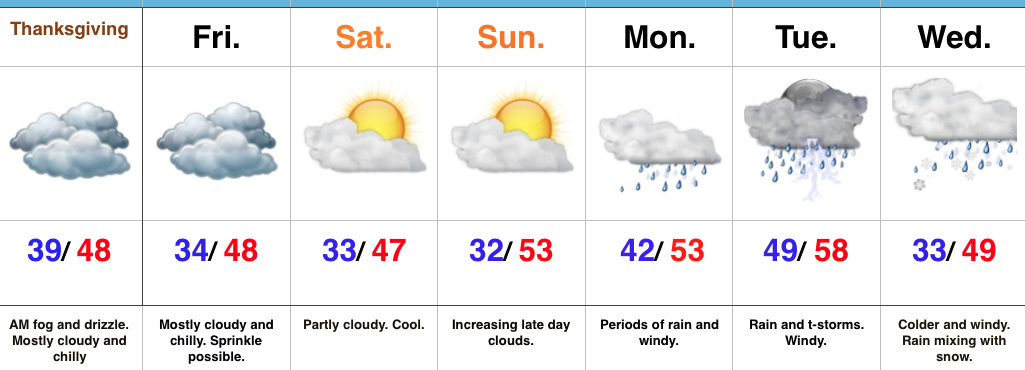
After a wet, raw, and dreary Wednesday, Thanksgiving will be drier.  Unfortunately, a large chunk of the day will likely feature low clouds, areas of fog, and drizzle, especially in the morning.  Reinforcing cool air will blow in as shoppers hit the stores Friday, along with gusty winds and a possible sprinkle.  Saturday will be chilly and blustery.  After a Sunday morning freeze, moderating temperatures will develop as we close the weekend and open the new work week.  This will be courtesy of SW winds ahead of a significant storm system that’s brewing next week.

Clouds will increase late Sunday and rain will follow Monday.  Rain will increase in coverage and intensity and we’ll also add in the potential of strong storms into the mix Tuesday.  (More details to come once we move closer, concerning strong to potentially severe prospects Tuesday).  Much colder air will pour into the region behind the storm system and allow precipitation to mix with wet snow Wednesday.

This is only the beginning of what looks to be a very stormy and increasingly cold weather pattern.  Longer-term model data suggests this will be the story throughout the majority of December.  Our call of a snowier than normal December remains…

Upcoming 7-Day Precipitation Forecast:

  • Snowfall: 0.00″
  • Rainfall: 2.50″-3.50″

Busy And Chilly Thanksgiving Week…

screen-shot-2016-11-21-at-7-24-27-amHighlights:

  • Unseasonably cold, but dry to kick off Thanksgiving week
  • Next system blows in with showers Tuesday night
  • Dry Thanksgiving

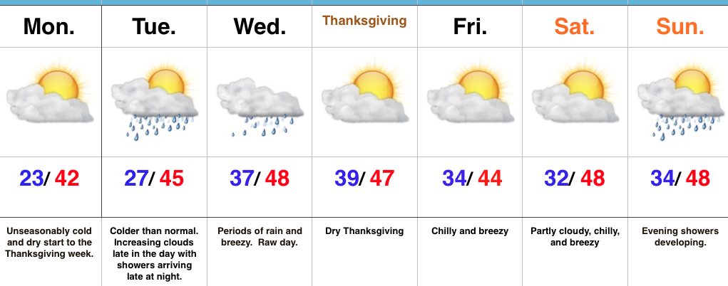
Active Week…Some folks across central Indiana are waking up to temperatures in the upper 10s this morning (looking at you Crawfordsville) and most everyone else is being greeted by lower to middle 20s out the door!  It’s a very cold start to the day.  Thankfully, dry conditions will remain today and through the daytime Tuesday.  Clouds will be on the increase Tuesday, but we should hold off on rain until late at night.  Unfortunately, the big travel day Wednesday will feature periods of rain and blustery, chilly conditions.  It’ll be a raw day.

We’ll dry things out for Thanksgiving, itself, along with seasonable temperatures.  Reinforcing chilly air will blow into town Black Friday and our next storm system of interest will arrive Sunday.  Most of the day Sunday will feature dry conditions before rain arrives on the scene by evening.

Upcoming 7-Day Precipitation Forecast:

  • Snowfall: 0.00″
  • Rainfall: 1.00″-1.50″

Snowy; Increasingly Cold December Expected…

The 2016-2017 IndyWx.com Winter Outlook was posted on October 30th. If you haven’t had an opportunity to see it, you can here.  Right out of the gate, we remain bullish on the prospects of a snowy holiday stretch this year, including above average snowfall for the month of December (average December snowfall at IND is 6.9″).

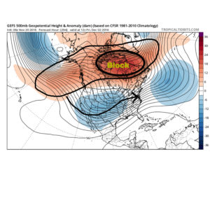
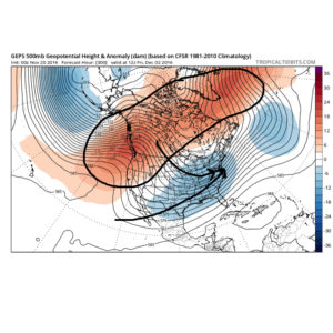
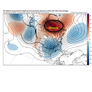
We continue to undergo that “step-down” process within the pattern, but there are growing signals that suggest the pattern takes on a very “blocky look” as we rumble into December.  When we talk about a blocking pattern in this instance, we’re specifically talking about high-latitude blocking.  Essentially this is when high pressure sets up in the high latitude regions (Greenland or northern Canada, for example).  Textbook blocky patterns feature high pressure that sustains itself and is very persistent, leading to a “log-jam” of sorts in the weather pattern, and playing a pivotal role in locking cold, stormy weather in for lengthy periods of time across the Lower 48.  Many times this is a “feedback” type scenario, meaning the early period of blocking patterns initially turns stormy and then grows progressively colder as the snowpack is laid down further and further south.

When we look at the medium-range and longer-term model data, we note the blocky pattern developing as we wrap up November and rumble into December.  The European, Canadian, and GFS ensemble data all shows the stormy look evolving.epsblockgefsblockgepsblockThe Weeklies also show this pattern in the longer-term.  While we can’t show the European data here (due to licensing), we can show the JMAs.  Again, note the high-latitude blocking.
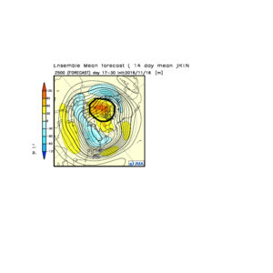
jmaweekliesblockActive times are ahead as a busy storm track develops.  Perhaps the scene for many will look a little something like this as we push into the Christmas season…

2d8dc26454216c3ca978614ecc98faa4In the meantime, gas up the snow blower and sharpen the snow shovel.  If our idea is correct, a snowier than average December will come out of this blocky pattern.