PM Strong Storms…

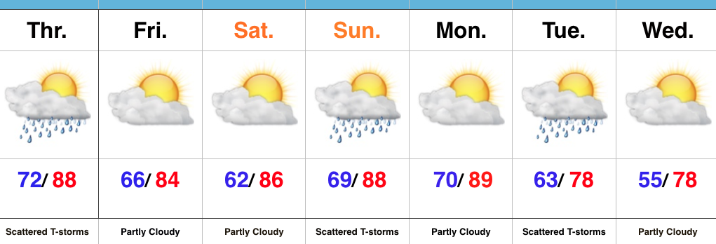
The morning is off to a sunny, muggy, and warm start.  Temperatures will rise into the lower 90s this afternoon, but when we look at heat indices, it’ll feel like around 100 degrees across many central IN neighborhoods.

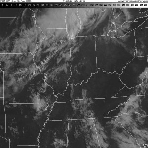
The visible satellite shows the sunny skies in place right now, but we note the cloud deck off to the northwest.  That’s in association with a frontal boundary that will press through our region tonight.

Vis
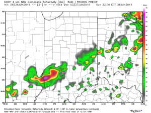
A line of thunderstorms will develop later this afternoon and a few of these could be strong to severe as they push to the south.  Large hail and damaging straight line winds are of greatest concern.  We think best chances of thunderstorms across central IN will come during the mid to late afternoon hours into the early evening.

3p

6p

1

11p
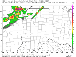
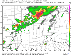
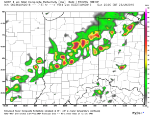
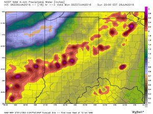
The air mass is loaded with moisture today.  In fact, precipitable water values will zoom to 2″+ this afternoon and suggest the threat of torrential rainfall with any storm that develops.

2Once to Tuesday, a MUCH cooler, drier air mass will arrive on the scene and help set up an unseasonably cool close to the month.

Permanent link to this article: https://indywx.com/pm-strong-storms/

Fantastic Saturday!

Screen Shot 2016-06-25 at 8.58.02 AMHighlights:

  • Beautiful Saturday
  • Storms return Sunday
  • Much cooler next week

Couldn’t Ask For Better Weather…After a week filled with multiple days of rain and storms, we’re rewarded with simply phenomenal weather today!  Dry conditions and mostly sunny skies will combine with lower humidity and highs in the mid/ upper 80s to create a great day to be outdoors.

Humidity will return Sunday and a frontal boundary will press in during the afternoon.  Storm chances will be on the rise and a strong to severe storm can’t be ruled out.  While storm coverage won’t be as widespread as this past week, we’ll keep an eye on the radar tomorrow evening.

The big story next week is the MUCH cooler air mass that will blow into town.  A shower will accompany the unseasonably cool air Tuesday before we return to mostly dry conditions for the middle of the week.

Upcoming 7-Day Precipitation Forecast:

  • Snowfall: 0.00″
  • Rainfall: 0.25″-0.75″

Permanent link to this article: https://indywx.com/fantastic-saturday/

Drier Air Works In Later This Evening; Eyeing A Cool Close To The Month…

Screen Shot 2016-06-23 at 7.59.42 AMHighlights:

  • Stormy times later today, especially south
  • Drier air mass works in
  • Storms return Sunday
  • Cooler to close the month

The Clean Up Begins…It was an active (and long) night across central IN as storms rumbled through.  Thankfully, the clean up will take place with dry conditions today for most of us.  For our southern viewers, we expect more widespread thunderstorms to fire during the afternoon and evening hours as a frontal boundary drops south.  We think most of central IN is dry today.

A drier, more refreshing air mass will filter into the region to close the week and head into the weekend.  Sunshine will prevail.

Warmth and humidity will be on the uptick for the second half of the weekend and storms will be associated with the moisture return.  Saturday is definitely the pick of the weekend!

Cooler times loom to wrap up the month…

Upcoming 7-Day Precipitation Forecast:

  • Snowfall: 0.00″
  • Rainfall: 0.50″-1.00″

Permanent link to this article: https://indywx.com/drier-air-works-in-later-this-evening-eyeing-a-cool-close-to-the-month/

Video Update On Tonight’s Severe Weather Event…

You must be logged in to view this content. Click Here to become a member of IndyWX.com for full access.  Already a member of IndyWx.com All-Access?  Log-in here.

Permanent link to this article: https://indywx.com/video-update-on-tonights-severe-weather-event/

Wednesday Morning Update…

The first of two waves of showers and thunderstorms is moving through the region this morning.  It’s the second wave of storms this evening/ tonight that has most of our attention.

The Storm Prediction Center has included more of central IN in a Moderate Risk of severe weather with the morning update.

IN_swody1All modes of severe weather are possible this evening and tonight, including tornadoes, hail, and damaging straight line winds.  Localized flash flooding is also possible where storms train.

Specific timing remains in question and we’re still not confident in the way short-term model data is handling the situation.  Fine tuning will be required as we move into the afternoon hours.

Once we rid the morning storms, clearing should develop for the afternoon and help boost temperatures into the middle 80s.  Sunshine is a bad thing this afternoon.  It won’t take much to destabilize things and ignite the second round of storms to our northwest this evening (southern WI/ northern IL).  That second round of storms is the one expected to pack a punch for some as they race southeast.

Have a means to get the latest weather information later today and ensure your family’s severe weather plan is in place.

Much more later this afternoon!

Permanent link to this article: https://indywx.com/wednesday-morning-update-2/