Early Fall Feel Coming…

Screen Shot 2016-08-17 at 10.08.38 AMHighlights:

  • Scattered Showers
  • Saturday storm chance
  • Early fall feel on deck

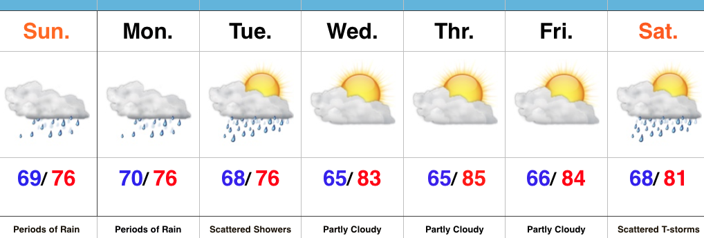
Drier Overall…It’s been a wet few days across the region.  While we’ll begin to transition towards a drier regime to wrap up the work week, scattered showers and storms will remain in the forecast today and Thursday.  Best concentration of storms will be located across north-central IN this evening.  Rain/ storm coverage will be even less on Thursday.

Our next item of interest will arrive on the scene in the form of a cold front Saturday.  Showers and a couple gusty thunderstorms are a good bet Saturday afternoon/ evening as the cold front sweeps through the state.  Our winds will then shift to the northwest and help usher in a much cooler, drier time of things for the second half of the weekend.  Stepping outside Sunday morning will provide a definite hint of fall, complete with a breezy NW wind.

Early next week will continue to feature dry and unseasonably cool times before we turn our attention to what could potentially be a heavy rain maker setting up just past the 7-day period…

Upcoming 7-Day Precipitation Forecast:

  • Snowfall: 0.00″
  • Rainfall: 0.50″-0.75″

Permanent link to this article: https://indywx.com/early-fall-feel-coming/

Another Wet Day…

Screen Shot 2016-08-16 at 7.37.17 AMHighlights:

  • Periods of rain
  • Increasing sunshine as we push into late week
  • Weekend cold front

Keep The Rain Gear Handy…Whew, after an incredibly busy evening, things will be much quieter today.  Despite not having a severe threat, we will have to deal with wet times as periods of rain continue.  Rain coverage will diminish Wednesday, but we’ll keep scattered showers in the forecast.

Drier air will arrive Thursday and Friday, including a partly cloudy sky.  The next weather item on the horizon is a weekend cold front.  This frontal boundary will help increase storm chances Saturday into early Sunday (a few storms Saturday evening could be on the strong side).  MUCH cooler, early fall-like, air awaits next week…

Upcoming 7-Day Precipitation Forecast:

  • Snowfall: 0.00″
  • Rainfall: 0.75″-1.25″

Here are a few photos I shot Monday evening (8.15.16), between 6:47p-6:55p, just after the tornado touched down in Whitestown.

Tornado81516

Tornado281516

Tornado381516

Tornado481516

Tornado581516

Permanent link to this article: https://indywx.com/another-wet-day/

Wet Day; Enhanced Flood Risk Tonight For Some…

The National Weather Service has expanded the Flash Flood Watch to encompass more of the viewing area.  This is in effect until 8p Tuesday.

Screen Shot 2016-08-15 at 7.26.16 AM
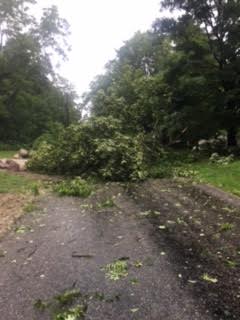
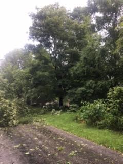
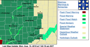
No doubt about it, today will be very wet across the entire region, including periods of heavy rain- especially across the western half of the state.

3

4
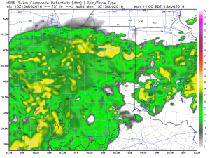
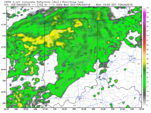
Tropical moisture will continue to stream into the state tonight into Tuesday.  In fact, most intense rains will likely set up tonight and may feature “banding” signatures that would train over the same areas.  Within these intense rain bands, prolific rainfall rates can be expected, enhancing the flash flood risk.  Latest short-term model data shows this threat, and would place a premium focus on areas generally west of US-31.  We’ll have to keep a close eye on things.

2
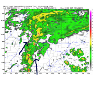
Plenty of “juice” is available to tap into across western sections tonight.  Precipitable water values (PWATs) of 2″-2.5″ will be more than enough to fuel torrential rainfall.

hrrr_pwat_indy_16
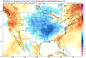
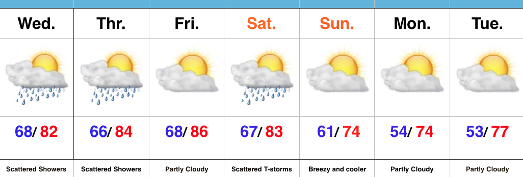
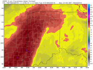
Eventually (mid and late week), we’ll dry things out and a significant cool down is still in store developing this weekend into early next week.  Lows will fall deep into the 50s with highs only in the 70s.  Talk about an early taste of fall…

gfs-ens_T2maMean_us_6

Permanent link to this article: https://indywx.com/wet-day-enhanced-flood-risk-tonight-for-some/

Heavy Rain Continues; Early Fall Preview Late Next Weekend…

Screen Shot 2016-08-14 at 9.57.05 AMHighlights:

  • Periods of heavy rain
  • Drying out come mid week
  • Cold front arrives next weekend

Flooding Concerns…Renewed heavy rain is pushing through central IN as we write up the morning forecast package.  This conveyor belt of moisture will continue to lift northeast and eventually break up and diminish during the late morning and early afternoon.  Despite scattered showers this afternoon, drier times will ensue, overall.  Unfortunately, this drier period won’t last long as another slug of moisture lifts north late tonight and continues Monday.   Additional heavy rainfall can be expected, including the potential of rainfall rates approaching 2″+/ hour.  Given the water-logged soils across the region, concerns of flash flooding are very high Monday.

Eventually, we’ll dry things out come mid week and introduce more sunshine back into the forecast.  Our next item on the agenda will be a cold front that will sweep through the state Saturday.  Scattered showers and thunderstorms will accompany the boundary as it moves through the region before much drier and cooler air blows in for the second half of the weekend.  In fact, a welcomed early fall preview awaits come Sunday.  Thoughts of football, pumpkin “everything,” bonfires, and apple cider will be prevalent this time next week…

Upcoming 7-Day Precipitation Forecast:

  • Snowfall: 0.00″
  • Rainfall: 2″-4″ (locally heavier totals)


Permanent link to this article: https://indywx.com/heavy-rain-continues-early-fall-preview-late-next-weekend/

“Lull” In The Rain Won’t Last…

Central Indiana is enjoying some needed “down time” in the rainfall department this evening, but this won’t last as rain coverage and intensity returns overnight and Sunday morning. Like today, locally heavy downpours will be likely.

Forecast radar at 4a

Forecast radar at 6a.

Forecast radar at 11a.


In looking at early 00z data, it appears as if we deal with (2) waves of rain Sunday:

Sunday morning will feature widespread rain across central Indiana, including localized heavy rain. Another “lull” in the activity will likely arrive Sunday afternoon into the evening hours, but we caution rain and embedded thunder will really begin to ramp up and increase in coverage and intensity yet again late Sunday night into the day Monday. 

The second surge of moisture is more in direct association with the tropical moisture and energy moving north. This area of rain will likely include embedded rates of 3″-4″/ hour for some very localized areas. It’s impossible to pin point where these areas are, but don’t be surprised to hear (or see) some very heavy rain Monday. 

A true Gulf of Mexico connection will be present Monday and aid in flooding prospects.


When we factor in expected rain from tomorrow and Monday, it would appear as if central IN is in line to accumulate an additional 2″-4″ with locally heavier amounts. Flooding prospects will increase dramatically Monday as heavy rain falls on saturated soils. Please, take warnings seriously. Rapid water rises are likely.

Permanent link to this article: https://indywx.com/lull-in-the-rain-wont-last/