
You must be logged in to view this content. Click Here to become a member of IndyWX.com for full access. Already a member of IndyWx.com All-Access? Log-in here.
Permanent link to this article: https://indywx.com/video-so-long-pleasant-air-storm-chances-return/
Aug 23
It’s Still Summer, After All…
 Highlights:
- Dry pattern continues today
- Mid week storms
- Questions abound this weekend
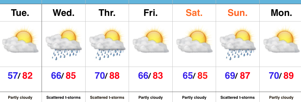
Heat And Humidity Return…High pressure will give way to an approaching cold front as we progress from early to mid week. Ahead of the front, a southwest air flow will transport an increasingly warm and muggy air mass northward. It’ll, unfortunately, feel much more humid Wednesday and Thursday. With the frontal boundary nearby and the increased humidity, expect scattered to numerous thunderstorms Wednesday and Thursday (along with locally heavy downpours). A couple strong storms are also possible.
We still think drier air will press into central IN to wrap up the work week and head into the first half of the weekend. That said, moisture returns as early as Sunday and leads to a mention of thunderstorms, especially during the PM. Stay tuned as we continue to fine tune timing.
Upcoming 7-Day Precipitation Forecast:
- Snowfall: 0.00″
- Rainfall: 1.00″-1.50″
Permanent link to this article: https://indywx.com/its-still-summer-after-all/
Aug 21
An Early Taste Of Fall…
 Highlights:
- Cooler and mostly sunny
- Dry weather into the early parts of the work week
- Midweek storms
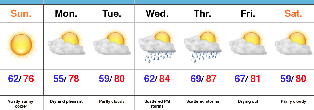
Early Fall Preview…A cold front swept through the state last night and was accompanied by strong storms and heavy rain. The unsettled conditions are now to our east and in return we’re left with a much cooler, drier, and breezy day. With low humidity, temperatures running significantly below normal, and a NW breeze in place, you have our approval to begin shifting thoughts to fall. 🙂
Dry and pleasant air will remain in place through early week before we back the air flow around to the SW. Increasingly muggy conditions will return Wednesday into Thursday and as a cold front interacts with the moist air in place, showers and thunderstorms will be on the increase Wednesday into Thursday. The good news? The front should slide to our south and result in dry and pleasant conditions next weekend.
Upcoming 7-Day Precipitation Forecast:
- Snowfall: 0.00″
- Rainfall: 0.50″-0.75″
Permanent link to this article: https://indywx.com/an-early-taste-of-fall/
Aug 20
VIDEO: Unsettled Now, But A Beautiful 2nd Half Of The Weekend Ahead…
You must be logged in to view this content. Click Here to become a member of IndyWX.com for full access. Already a member of IndyWx.com All-Access? Log-in here.
Permanent link to this article: https://indywx.com/video-unsettled-now-but-a-beautiful-2nd-half-of-the-weekend-ahead/
Aug 18
Scattered Storms; Turning Much Cooler…
 Highlights:
- AM fog burns off today
- Scattered storms
- Much cooler air coming
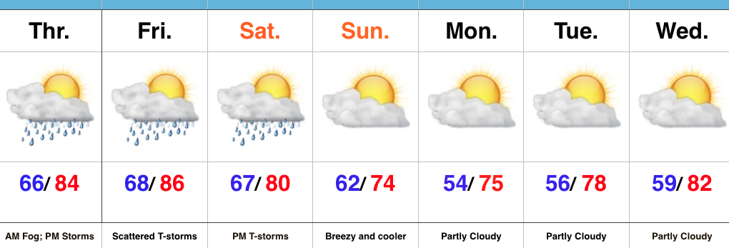
Afternoon And Evening Thunder…Morning fog (some dense) will eventually burn off and give way to a muggy day. As afternoon heating takes place, scattered evening thunderstorms are a good bet, especially north of Indianapolis. We’ll repeat this to wrap up the work week Friday.
A cold front will take aim at the region Saturday evening and scattered showers and thunderstorms will accompany this boundary as it moves through. A few storms could reach strong to severe levels Saturday PM as the front moves through.
Winds will shift to the NW and usher in a much cooler and drier brand of air for the second half of the weekend, continuing into the early portion of next week. Many will likely be craving fall by early next week coming off multiple mornings with lows in the 50s.
Upcoming 7-Day Precipitation Forecast:
- Snowfall: 0.00″
- Rainfall: 0.50″-1.00″
Permanent link to this article: https://indywx.com/scattered-storms-turning-much-cooler/
