 Highlights:
- One more pleasant day
- Humidity increases
- Storm chances return
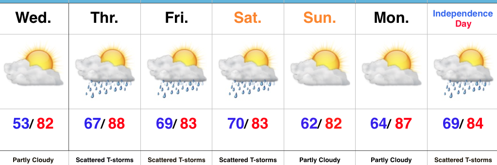
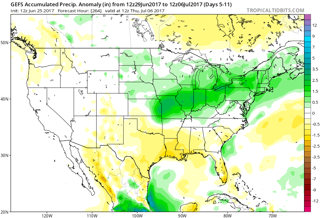
Unsettled Weather Looms…We’ve got one more pleasant day to enjoy, but take advantage of it as changes for a more tropical-feel loom. With that increasingly warm and moist air, we’ll also see an increase in showers and thunderstorms as we wrap up the week. While it won’t rain the entire time, a couple rounds of strong-to-severe thunderstorms are possible during the Thursday afternoon-Friday period.
We think we return to drier conditions late weekend into Monday, but this drier theme likely won’t hold through the holiday period. Scattered showers and thunderstorms return by Independence Day.
Upcoming 7-Day Precipitation Forecast:
- Snowfall: 0.00″
- Rainfall: 1.00″ -1.50″ (locally heavier totals)
Permanent link to this article: https://indywx.com/muggy-air-and-storm-chances-returns/
 Highlights:
- Scattered storms this evening
- Pleasant air continues for now
- More humid and stormy by late week
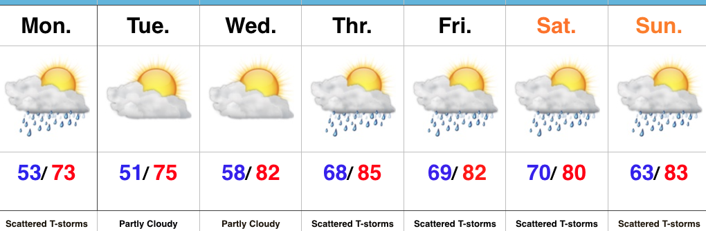
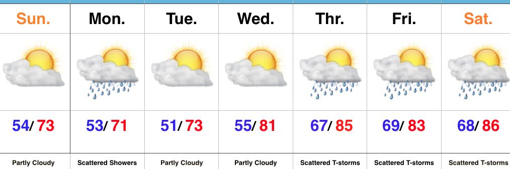
Pleasant Start Ends With Storms For Some…We couldn’t ask for more beautiful weather conditions for the last week of June. Hopefully you were able to get outside and enjoy these pleasant conditions over the weekend. If not, you still have a couple days to do so. Despite the sunny start to the day, enough upper level energy will move overhead this evening to help spark scattered showers and thunderstorms. Initially these storms will fire over northern Indiana before settling south through the evening. We think greatest coverage across central parts of the state will arrive between 6p-10p before these storms push south and diminish. Localized brief heavy downpours are possible, but, overall, this won’t be a significant, widespread heavy rain event.
We’re back to dry and pleasant conditions through Wednesday, but humidity will be on the rise by Thursday and so will shower and thunderstorm chances. We’ll have to monitor the potential of a couple rounds of gusty storms and heavy rain late week and we’ll have to fine tune timing as we get closer. Unsettled weather conditions will continue into the holiday weekend ahead.
Upcoming 7-Day Precipitation Forecast:
- Snowfall: 0.00″
- Rainfall: 1.50″-2.00″
Permanent link to this article: https://indywx.com/pleasant-air-evening-storms-for-some/
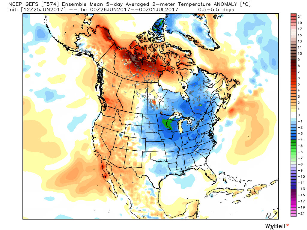
I. The new work week will open up with a continuation of unseasonably cool temperatures. Speaking of temperatures, how nice has it been to have air equivalent of late-September as we get set to wrap up the month of June?!
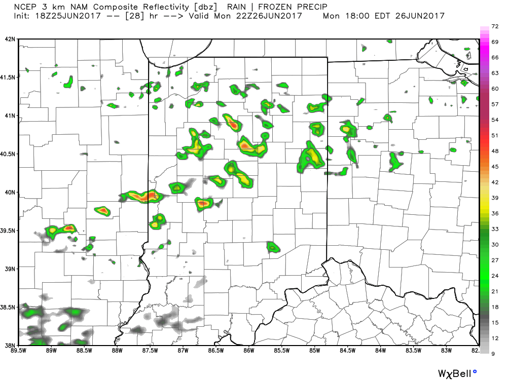
 II: A weak upper level disturbance will drift overhead Monday afternoon and help spark scattered showers and thunderstorms into the evening hours. Not everyone will get wet Monday evening, but a couple gusty storms are possible. Here’s a look at the radar valid at 6p Monday.
 III. After a dry Tuesday and Wednesday, better shower and thunderstorm chances will return to our forecast for late week into next weekend. Additionally, temperatures and humidity levels will return to closer to seasonal norms.
 IV. An active pattern will remain with us as we progress through the first half of June. A busy NW flow aloft will likely send multiple storm clusters southeast into the region and we’ll have to be mindful for the potential of some of these storm complexes containing strong-to-severe storms and excessive rainfall.
Permanent link to this article: https://indywx.com/another-week-is-upon-us-looking-ahead/
 Highlights:
- Early fall-like feel
- Shower chance to open the work week
- More humid late week
Beautiful Weather Continues…To help put this weather into perspective- our average low and high in late September falls in the lower 50s with highs in the lower to middle 70s. For the next few days, an early fall-like feel will grip central Indiana, and you won’t hear many folks complaining about it! (Personally, I say let’s skip right to those crisp late September days and football season :-))! Despite a weak upper level disturbance creating a shower chance Monday, we’re dry through midweek.
A return southwesterly air flow will arrive on the scene by late week and this will serve to help boost temperatures and humidity levels, along with assist in creating a better chance of scattered to numerous showers and thunderstorms late week into next weekend. Let yours truly worry about that and you be sure to enjoy this rare late June air!
Upcoming 7-Day Precipitation Forecast:
- Snowfall: 0.00″
- Rainfall: 1.00-1.50″
Permanent link to this article: https://indywx.com/early-fall-like-weather-continues/
 Highlights:
- Heavy rain and storms through the daytime
- Much cooler and drier air on the way
- Pleasant week ahead
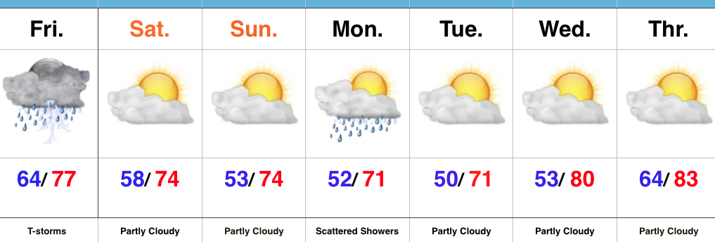
Tropical Downpours Today…The remnant tropical moisture of Cindy is lifting northeast this morning while a cold front is dropping south. The combination of these two weather features will result in an expanding area of rain and thunderstorms across central Indiana late morning into the early afternoon. Periods of heavy rain can be expected. Thankfully, this won’t be a long duration event and a much drier air mass will invade from northwest to southeast by evening. We’ll easily notice this drier trend as dew points go from about as high (lower-middle 70s) as we ever see them this morning to a very crisp feel (dew points in the 50s) tonight.
The cooler and drier theme will continue through the weekend into the majority of the upcoming week ahead. As noted in previous discussions, a fast-moving northwest flow will be responsible for sending a couple of minor upper level disturbances southeast into the region. For the most part, we believe scattered showers will remain north of central Indiana until Monday afternoon and evening. While this won’t be a significant event by any stretch of the imagination, a couple of showers are possible.
Our air flow will eventually shift around to the southwest by the middle of the week and this will begin to send a warmer and increasingly moist air mass north by Thursday.
Upcoming 7-Day Precipitation Forecast:
- Snowfall: 0.00″
- Rainfall: 1.50″ – 2.00″ (locally heavier amounts)
Permanent link to this article: https://indywx.com/heavy-rain-gives-way-to-a-gorgeous-weekend/

