
You must be logged in to view this content. Click Here to become a member of IndyWX.com for full access. Already a member of IndyWx.com All-Access? Log-in here.
Permanent link to this article: https://indywx.com/video-wintry-open-to-the-week-cold-hangs-through-late-march/
Mar 11
Week Ahead: Cold Open Gives Way To Warmer Air In Time For St. Patrick’s Day…
A storm system will gather strength to our south as we progress through the day and into the night. While central Indiana won’t experience significant impacts from this storm, we’ll indirectly deal with this system with considerable cloudiness and a chilly easterly breeze today.
Our friends to our south (KY and the higher elevations of the southern Appalachians) can expect accumulating snow. The east TN and western NC mountains will accumulate over 6″ above 5,000 feet late tonight through Monday morning.
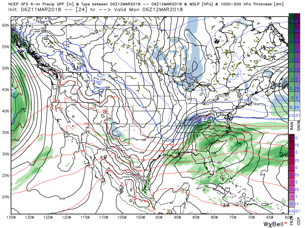 The region will be under the grips of a cold northerly flow through the first half of the work week. Embedded within that air flow will be a couple of upper level disturbances that will drop into the Ohio Valley. These impulses of energy will help kick off snow showers and localized heavier squalls at times Monday through Wednesday. Some localized accumulations of a dusting to 1″ will be possible.
 High pressure will gain control of our weather Thursday and this will include the start of a nice moderating trend for the second half of the week, including the St. Patrick’s Day weekend. With full sunshine Thursday, along with WAA (warm air advection) kicking in, we think highs will top out much warmer than the majority of current guidance suggests. We’ll go with widespread mid to upper 50s Thursday.
 Unfortunately, we’ll add more clouds and showers next weekend. Wet weather will build in Friday and we can’t rule out shower chances Saturday, as well. Temperatures will warm well into the 60s by St. Patrick’s Day!

 In general, we expect 0.25″ to 0.50″ across central IN with showers in the Friday-Saturday time period.
Permanent link to this article: https://indywx.com/week-ahead-cold-open-gives-way-to-warmer-air-in-time-for-st-patricks-day/
Mar 10
VIDEO: Saturday Morning Thoughts On Late March…
In the midst of trying to keep Bo, our youngest golden doodle, from becoming a tremendous distraction in this morning’s video, here are some thoughts on what lies ahead over…
You must be logged in to view this content. Click Here to become a member of IndyWX.com for full access. Already a member of IndyWx.com All-Access? Log-in here.
Permanent link to this article: https://indywx.com/video-saturday-morning-thoughts-on-late-march/
Mar 09
VIDEO: Weekend And Beyond…
You must be logged in to view this content. Click Here to become a member of IndyWX.com for full access. Already a member of IndyWx.com All-Access? Log-in here.
Permanent link to this article: https://indywx.com/video-weekend-and-beyond/
Mar 08
Long Road Ahead To Sustained Spring…
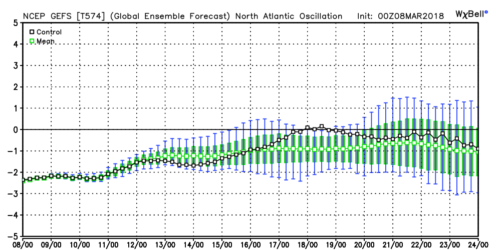
We note the modeling continues to want to keep the North Atlantic Oscillation (NAO) negative into late month. As mentioned in previous discussions, the NAO is “king” late winter and spring.
 It should be no surprise that the GEFS 5-day temperature anomaly shows widespread below normal air centered on March 22nd.
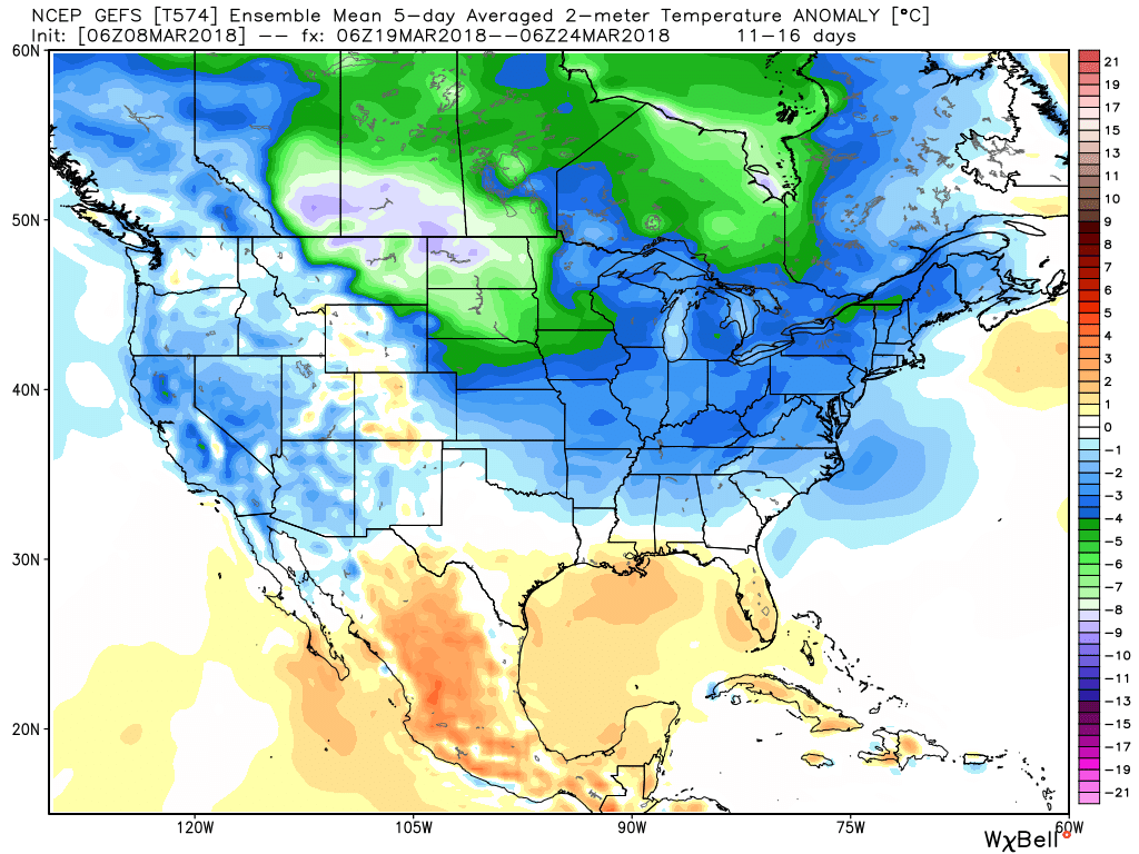 This doesn’t mean brief surges of warmth, originating in the southern Plains, can’t shoot into the Ohio Valley for a couple of days. Perhaps we’ll “luck out” and enjoy a briefly milder time for St. Patrick’s Day. This does, however, mean that overall we have a long, long way to go before “stick and hold” spring can arrive, locally, and the balance of the upcoming 2-3 weeks looks colder than average.
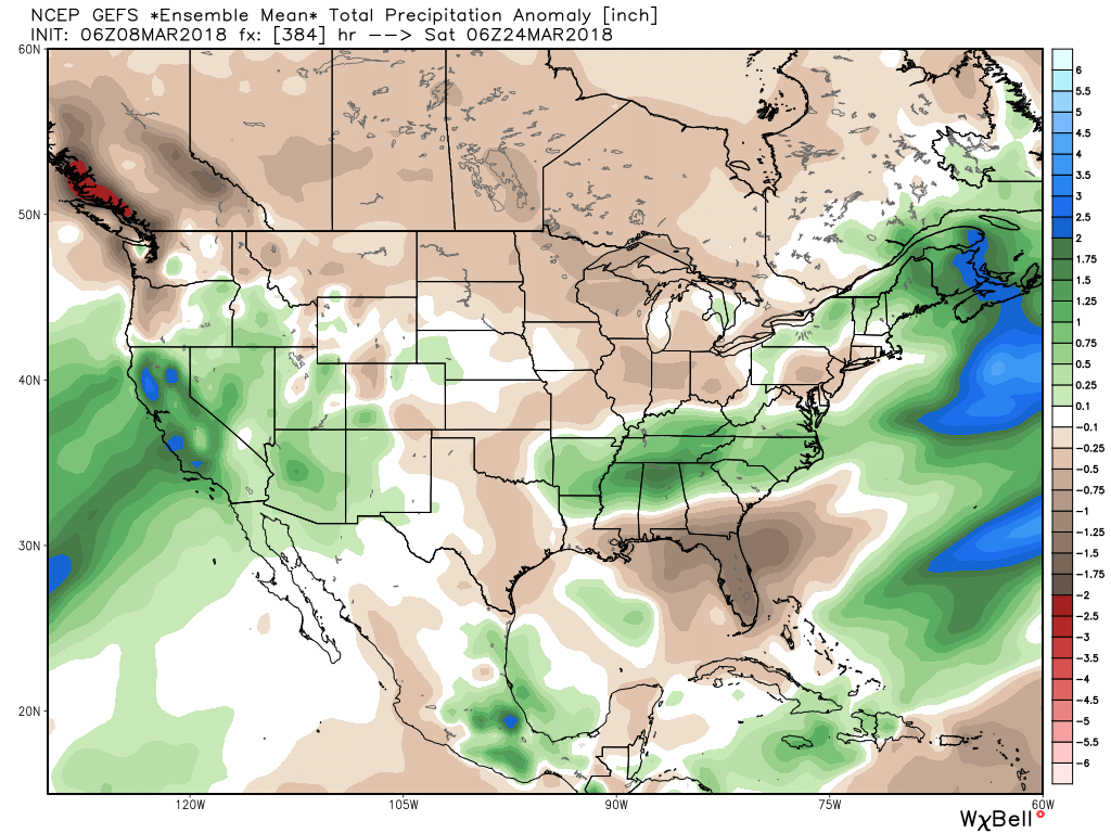
Side note: The upcoming couple weeks looks drier than average for our region, while the TN Valley into the Carolinas remains abnormally wet. Our friends in the southern Plains continue to deal with dry times and the drought will only worsen in coming weeks there…
Permanent link to this article: https://indywx.com/long-road-ahead-to-sustained-spring/
