
You must be logged in to view this content. Click Here to become a member of IndyWX.com for full access. Already a member of IndyWx.com All-Access? Log-in here.
Permanent link to this article: https://indywx.com/video-enjoy-todays-sun-heavy-rain-and-storms-build-in-for-midweek/
Mar 16
VIDEO: Discussing Rain Amounts And Storm Potential This Week; Colder Close To March?
You must be logged in to view this content. Click Here to become a member of IndyWX.com for full access. Already a member of IndyWx.com All-Access? Log-in here.
Permanent link to this article: https://indywx.com/video-discussing-rain-amounts-and-storm-potential-this-week-colder-close-to-march/
Mar 15
Reviewing Saturday’s Snow And Looking Ahead To Another Busy Week…
Snow moved in during the predawn hours Saturday across north-central Indiana before encompassing more of central Indiana as the morning progressed. By mid-late morning, an incredibly intense band (2″+/ hour snowfall rates) set-up shop just north of Indianapolis. This was a byproduct of strong frontogenesis and dynamic cooling. Speaking of frontogenesis, if interested, here’s a fantastic article that can explain things further.
The end result was an “overachieving” wet snow event across north-central Indiana, including as far south as the northern Indianapolis ‘burbs. Sleet made it as far south as Greenwood before precipitation ended Saturday evening.
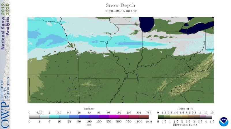
While the placement of our accumulating snow zone was a good one, amounts of 4″ to 5″ were reported throughout the southern half of this 1″ to 2″ forecast zone. This morning’s snowfall analysis shows the narrow, but moderate stripe of wet snow through the state:
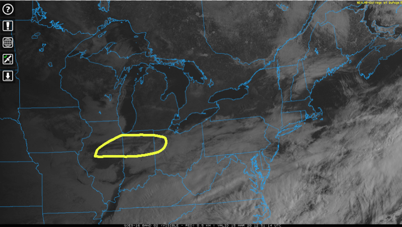
As the sun rises and clouds begin to depart, that snowpack is showing up on this morning’s visible satellite image.
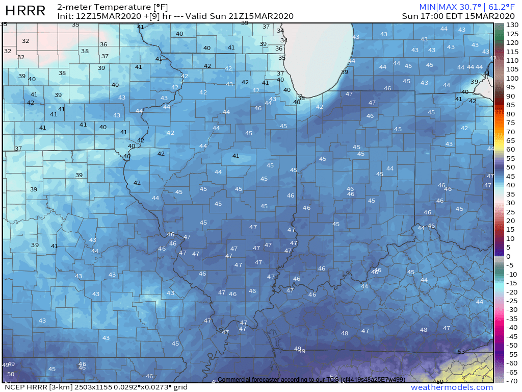
Officially, Indianapolis recorded 1.2″ Saturday, but as noted above, areas just north received as much as 4″ to 5″. With that increasing March sunshine today, snow will be all but a distant memory by later this afternoon. The average high for March 15th is in the lower 50s. Most will be 5° to 7° colder than that today with mid 40s for most.
As we turn the page and look ahead to what the remainder of the week will provide, a weak cold front will sweep through the Ohio Valley Monday night and Tuesday. This will be a moisture-starved frontal passage with only scattered, light showers anticipated tomorrow evening/ early Tuesday.

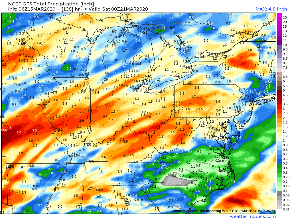
Things then turn much more unsettled as we head into the second half of the week. An initial wave of moisture will result in a period of moderate to heavy rain Wednesday. This will be followed up with a round of thunderstorms Thursday PM into early Friday morning. Some of these storms may reach strong to severe levels and will require us to continue to closely monitor things throughout the week.

Widespread 2″ to 2.5″+ rainfall amounts can be expected by the time everything winds down Friday afternoon. Most of that will fall Wednesday and Thursday night/ Friday morning.
We’ll dry out next weekend, but shift to a much colder time of things (lows in the 20s and highs in the 40s). This will come as a rather rude shock after highs Thursday flirt with the 65° to 70° mark.

Permanent link to this article: https://indywx.com/reviewing-saturdays-snow-and-looking-ahead-to-another-busy-week/
Mar 14
VIDEO: Wet Snow Accumulates For Some Today; Severe Weather Set-Up Late Next Week…
You must be logged in to view this content. Click Here to become a member of IndyWX.com for full access. Already a member of IndyWx.com All-Access? Log-in here.
Permanent link to this article: https://indywx.com/video-wet-snow-accumulates-for-some-today-severe-weather-set-up-late-next-week/
Mar 13
March Snow Events Are Always Fun: Discussing Placement/ Accumulation Amounts…
Saturday morning will open with a lowering and thickening cloud canopy and moisture will soon follow. We expect precipitation to arrive first on the scene across north-central Indiana (between 8a and 10a) and likely fall predominantly as wet snow. Further south (closer to Indianapolis), a mixture of rain and snow is expected to develop between 11a and noon. All rain is anticipated across southern parts of the state.
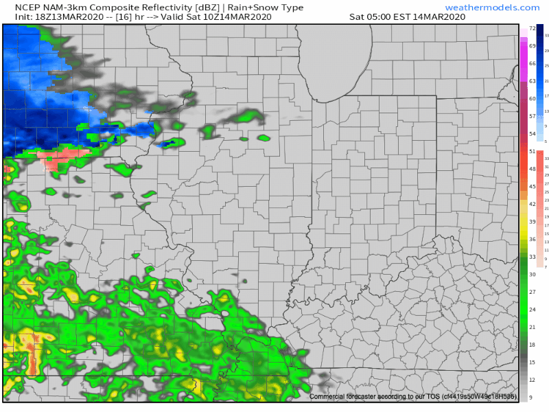
Once the precipitation arrives, it’ll set up shop for the better part of the rest of the day. It won’t be until closer to the 7p to 9p timeframe that we’ll begin to see the mixture of rain and snow exit the state from west to east.
Temperatures will be marginally cold (lower-middle 30s) throughout the event, and we’ve also discussed the challenge of getting snow to accumulate with that increasingly high March sun angle. That said, even with marginally cold temperatures, if we can generate heavier precipitation rates, areas north of the city can expect to accumulate an inch or two of wet snow. Significant pavement impacts aren’t expected.
Here’s our snowfall forecast:

Temperatures will fall into the upper 20s to around 30 for all of central Indiana Saturday night and Sunday morning. Thankfully, high pressure will return and provide increasing sunshine for the 2nd half of the weekend. It’ll still be chilly with highs topping out in the middle 40s.
Permanent link to this article: https://indywx.com/march-snow-events-are-always-fun-discussing-placement-accumulation-amounts/
