
You must be logged in to view this content. Click Here to become a member of IndyWX.com for full access. Already a member of IndyWx.com All-Access? Log-in here.
Permanent link to this article: https://indywx.com/video-unseasonably-cool-air-dominates-this-week-changes-down-the-road/
Aug 01
Weekly #AGwx And #Severe Weather Outlook…
I. Isaias set to impact the eastern seaboard early week.
II. Unseasonably cool air dominates the period from the Plains into the Ohio Valley.

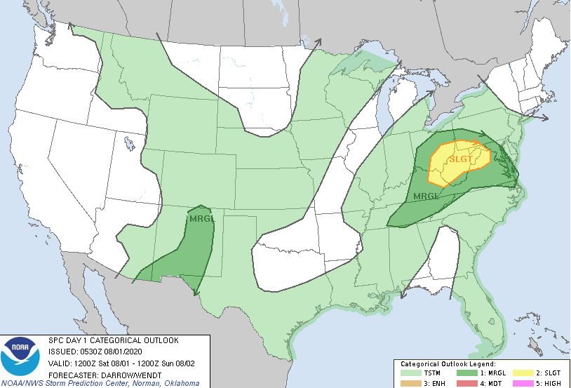
Severe: Widespread severe weather isn’t anticipated this week, with the exception of just east of the track of our surface low today (eastern KY, southeast OH, and northern VA) and into the Northeast Sunday.
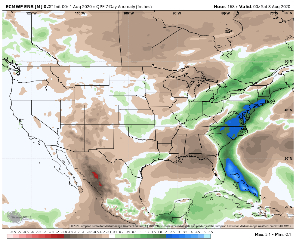
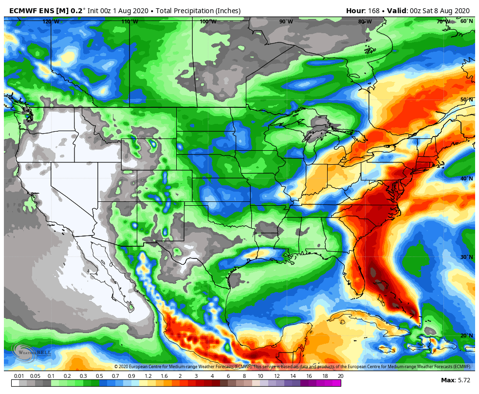
Forecast Period: 08.01.20 through 08.07.20
Our weather will be dominated by a trough and associated low pressure through the early portion of the work week. Initially it’s a surface low that will provide periods of rain and embedded thunder through the weekend, but by the time we get to Monday and Tuesday, it’s upper level energy that will be responsible for scattered showers and thunderstorms. Periods of heavy rain can be expected this afternoon into tonight, especially across east-central Indiana. Thereafter, drier air will arrive for midweek. With the drier airmass in place, temperatures will fall into the mid-upper 50s (average low is in the middle 60s). Our next weather feature (a weak cold front) will arrive next Friday with the potential of scattered showers and storms.
Isaias will skirt the eastern seaboard through the early portions of the week. While not a particularly well organized storm, tropical storm and low end cat. 1 hurricane force winds can be expected from eastern portions of the Florida peninsula and up the Carolina coast, into New England by midweek.
Permanent link to this article: https://indywx.com/weekly-agwx-and-severe-weather-outlook-16/
Jul 31
VIDEO: Wet Start To August Also Met With Much Cooler Than Normal Air…
You must be logged in to view this content. Click Here to become a member of IndyWX.com for full access. Already a member of IndyWx.com All-Access? Log-in here.
Permanent link to this article: https://indywx.com/video-wet-start-to-august-also-met-with-much-cooler-than-normal-air/
Jul 30
VIDEO: One-Two Punch Of Heavy Rain Into The Weekend; Cool Open To August…
You must be logged in to view this content. Click Here to become a member of IndyWX.com for full access. Already a member of IndyWx.com All-Access? Log-in here.
Permanent link to this article: https://indywx.com/video-one-two-punch-of-heavy-rain-into-the-weekend-cool-open-to-august/
Jul 29
August Outlook: Does The Refreshing Start Run The Duration?
Average August temperatures in Indianapolis feature highs falling from 84° to begin the month to 83° by months end, while average lows drop from 65° to 62°. We average 3.13″ of rain for the month as a whole.
There’s been a lot of chatter recently from local weather sources around how recent Augusts have run cooler than normal. Simply put, that’s not the case. Looking back to 2015, we’re running a clip of “every other year” running cooler than normal, locally.
As we look at August 2020 and the last month of meteorological summer, there are reasons to buy stock into cooler prospects, especially through the 1st half of the month. While there will likely be a rebound late month, it may not be enough to tip the scale towards the warmer side of normal.
Note the recent trends of the CFSv2. While never overly warm for our particular region, the model is expanding the cool for the month and pressing the relative warmth to the coasts.

Interestingly, the model is also developing a more consistent wet look.

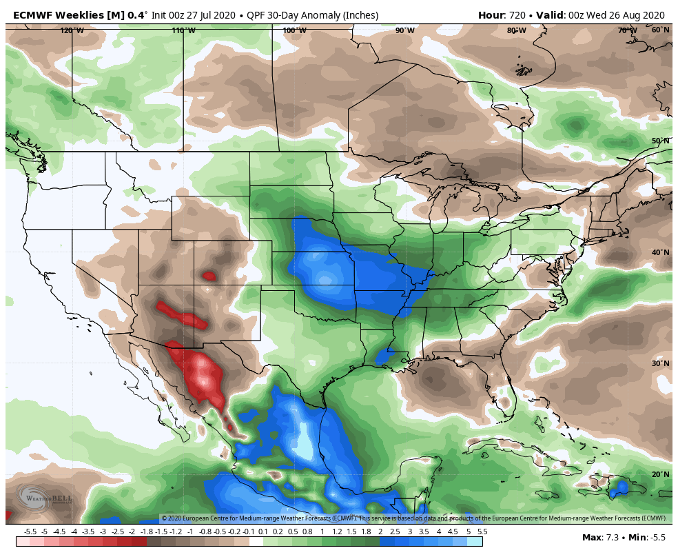
The latest European Weeklies have a similar (but not identical) look:

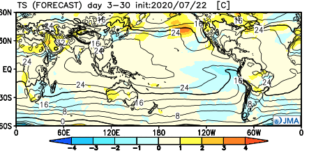
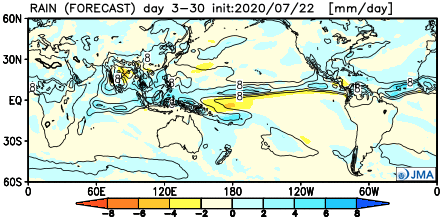
The JMA is in the same boat, as well:
A positive PNA is anticipated to rule through the majority of the month:

The wild card, as is always the case this time of year, will be the tropics. There’s reason to buy into the idea (outlined in previous discussions and videos) that the “heart” of the season will be hyperactive and that begins during the month of August. Obviously, it’s impossible to talk landfall/ inland impacts, but those with interests to the GOM (Gulf of Mexico) and East Coast should closely monitor the tropics through the month, and for that matter, into the fall months.
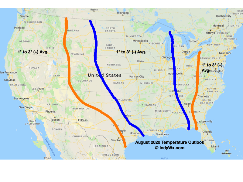
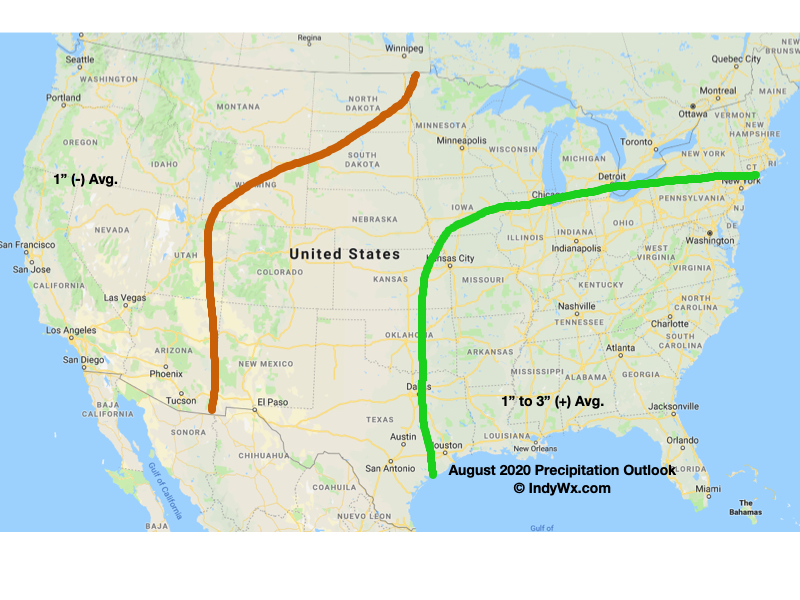
Officially, we expect a much wetter than normal month across central Indiana along with average temperatures. The cooler than normal 1st half of the month will likely be met with moderation (compared to normal and in the means) late month to balance things out close to average. Our official August forecast is below.
Permanent link to this article: https://indywx.com/august-outlook-does-the-refreshing-start-run-the-duration/
