More Weekend Snow Talk…

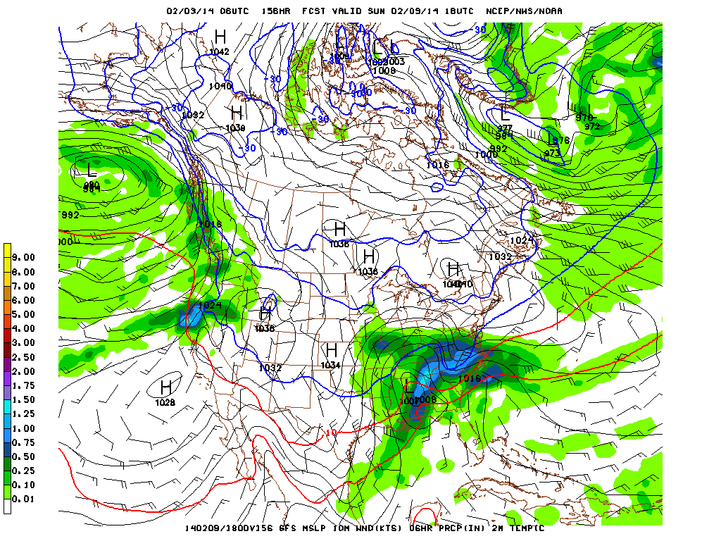
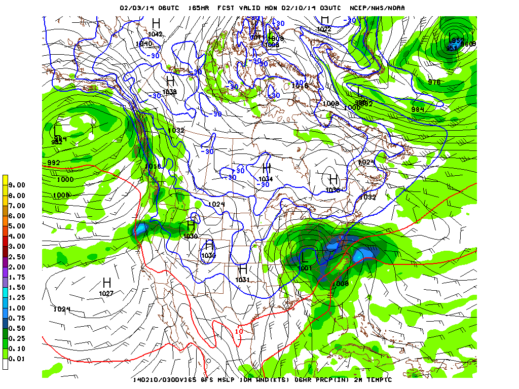
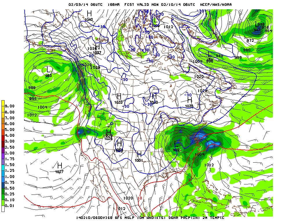
We’re still dealing with some questions that will have to be sorted out for the weekend’s snow.  Latest high resolution data suggests we may see a couple of waves of accumulating snow cross the state this weekend.  Namely, we’re focused on late Saturday night into Sunday morning and again Sunday night into Monday morning.  Scattered snow showers will fall during the day Saturday, but shouldn’t be a big deal and won’t impact everyone.

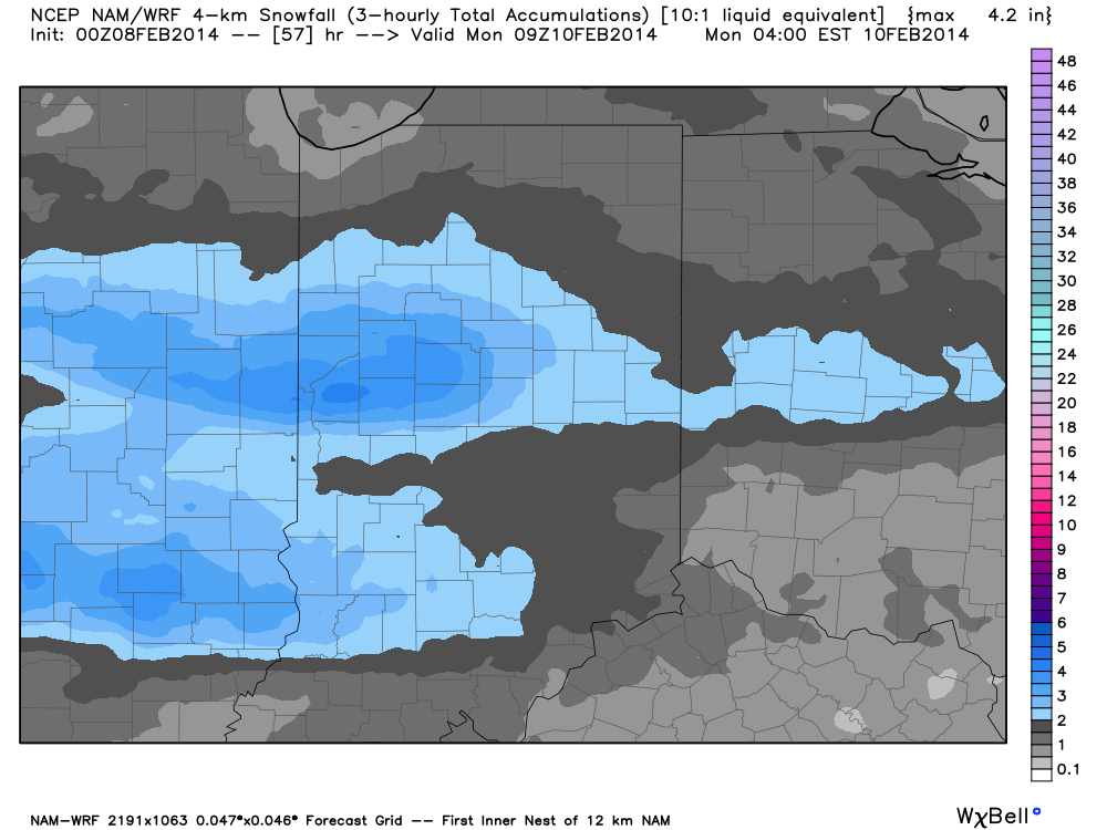
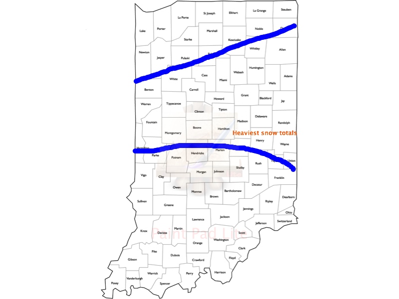
It’s a tough and challenging pattern we’re in over the next 60 hours and forecast models will continue to struggle with handling upper level energy as it ejects off the Rockies and heads east.  While our initial idea of a more organized, robust, storm system won’t come to fruition, it’s certainly possible some central Indiana neighborhoods deal with a “few” inches of fresh snow by Monday morning.  It’ll be important to stay tuned to latest forecasts this weekend as what may seem to be a rather harmless inch, or so, of snow could pile up to the tune of 2″-5″ for some areas should latest high resolution model data, hot off the press, come to fruition.

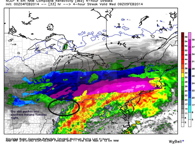
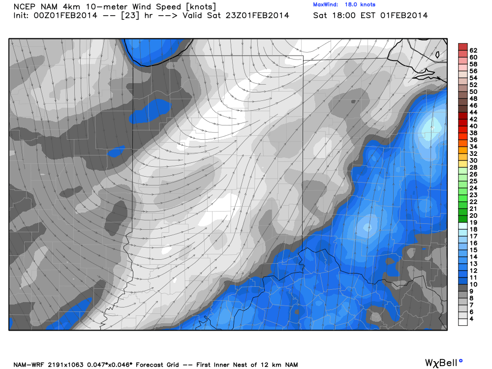
Case in point, the latest high resolution NAM model, courtesy of Weatherbell Analytics, paints a couple of stripes of snow across central Indiana and seems to have a pretty good handle on the evolution of things over the next 48-60 hours.  It should be noted that not all model data suggests accumulating snow is ahead this weekend.  THAT SAID, many times, in similar weather patterns, the high resolution data performed better.  We’ll fine tune things and have a fresh updated 7-Day forecast available to you in the morning.  Make it a great night!

hires_snow_acc_indy_19

Permanent link to this article: https://indywx.com/2014/02/07/more-weekend-snow-talk/

Bitterly Cold And Snowy Pattern Rolls Along…

Fri.

Sat.

Sun.

Mon.

Tue.

Wed.

Thr.

 Status-weather-clear-icon

 Status-weather-snow-scattered-day-icon

 Status-weather-snow-scattered-day-icon

 Status-weather-clear-icon

 Status-weather-clear-icon

 Status-weather-snow-scattered-day-icon

 Status-weather-snow-scattered-day-icon

-5/ 14

9/ 24

15/ 24

2/ 15

– 5/ 16

9/ 26

15/ 28 

0.00”

1”-2”

1”

0.00”

0.00”

1”

1”

Forecast Updated: 02.07.14 @ 8:07a

Frigid Close To The Work Week…Arctic high pressure will be centered over the Ohio Valley as we close out the work week.  While this will lead to a mostly sunny sky, downright frigid conditions can be expected.  The day will dawn with temperatures solidly below zero and include wind chill values as cold as 30 degrees below- a painfully cold start to the day, needless to say.

Watching A Weekend Snow Maker…We continue to keep a close eye on the weekend as another round of accumulating snow waits on deck.  Questions remain as to just how much snow accumulates and while model data continues to suggest we’re only looking at a light, 1-3″, weekend snow event at the moment, the chance is still there that modeling begins to trend a little more “robust” with upper level energy as it crosses the Ohio Valley.  High snow ratios will be at play here, meaning we’ll squeeze out more than the usual 1″ of snow for every 10th of an inch of liquid.  We bracket Saturday afternoon into Sunday morning as the best chance of accumulating snow, but note this timing could change as we move through the next 24 hours.  Stay tuned.

Weekend Snow Bookended By A Bitter Feel…A fresh blast of bitterly cold air will pour into the Ohio Valley and Mid West region to kick off the new work week.  Temperatures will average more than 20 degrees colder than seasonal levels to begin the new work week and feature at least one, if not two, night(s) below zero.  The brutally cold, snowy winter of 2013-2014 just keeps on keeping on…

Watching The Southern Stream…Model data is really struggling in the longer term and it has to do with how each respected model set handles energy in the southern and northern branch of the jet stream.  We’re taking a “middle of the line” approach for now, including chances of snow the middle of next week.

images

For weather updates and more “behind the scenes” data on the go, be sure to Follow Us on Twitter @indywx or become a Friend of IndyWx.com on Facebook!

twic

Permanent link to this article: https://indywx.com/2014/02/06/bitterly-cold-and-snowy-pattern-rolls-along/

Accumulating Snow Isn’t Finished

Good morning!  After a night complete with impressive snow totals, lightning and thunder reported downtown shortly after 6am, and significant drifting in the open country, things have “calmed” as of this post.  That said, the accumulating snow isn’t finished and will rotate back into central Indiana by late morning.

We think an additional 1-2″ of snow will fall with the highlighted area of snow below as it tracks east-northeast.  This snow is courtesy of the upper level low moving through the region.  Our storm total here at IndyWx.com HQ- 5 miles northwest of Zionsville is at 8.6″ so far.

ULSnow2514

Permanent link to this article: https://indywx.com/2014/02/05/accumulating-snow-isnt-finished/

Major Winter Storm Underway

11:00p update

Snowfall has been falling to “beat the band” the past couple hours across central Indiana.  Just within the past 54 minutes we’ve added 1.2″ here at IndyWx.com HQ in southeast Boone County.  Storm totals thus far are approaching 7″ as of this report.

While you’ll note the drier push of air invading portions of south-central Indiana, it’s likely accumulating snow continues across central Indiana, especially from the I-70 corridor and points north, becoming more widespread and growing in intensity yet again during the overnight.  The culprit?  The highlighted upper low which will “carry” accumulating snow east through the night into Wednesday…

ULDefZone

6:00p update

A major winter storm is underway and currently producing snowfall rates in excess of 1″ per hour across most of central Indiana.  We already have snowfall reports of 4-5″ coming in and those numbers will grow deeper and expand as we progress through the night.

This is a widespread winter storm and impacting a huge chunk of territory.  Here’s a look at the radar at 6:30, via Intellicast:

36

Notice the moisture connection with the Gulf of Mexico.  Moisture-rich air continues to stream north into the cold air mass in place and resulting in extreme snowfall rates of 1-2″ per hour…these will continue through the evening before intensity improves late tonight.

The Storm Prediction Center has had to issue a mesoscale discussion to account for the heavy snow ratios.  Additionally, don’t be shocked if you hear a rumble or two of thunder tonight in the heavier snow bands.

37


As we move forward, the dry slot, common with a mature cyclone, and discussed here originally Sunday will move northeast and result in a break in the snow across the region towards the 11 o’clock hour from the southwest.

38

That said, snow will “fill” back in across central Indiana early Wednesday morning and produce additional accumulations.

40

Much more later!

Permanent link to this article: https://indywx.com/2014/02/04/major-winter-storm-underway/

Here We Go Again…

Yet another winter storm is bearing down on the region and will promise a snowy time of things here Tuesday evening into Wednesday.

Surface low pressure will begin to organize over the lower Mississippi River Valley Tuesday morning and move northeast…eventually into PA before a secondary low takes over off the Northeast coast Wednesday.  We like our track of the storm below.

TueWedStormTrack


This will really be the first storm that’s tapped into Gulf of Mexico moisture since the major winter storm that pounded our area early last month.  Moisture will be plentiful with this system and, when combined with the cold air, will lead to significant snow accumulation for most of central Indiana, with significant ice accumulation expected downstate across southern sections of Indiana.

We think snow begins to develop across central Indiana as early as early to mid afternoon Tuesday, but the heaviest of the snow will fall Tuesday night into the wee morning hours Wednesday.  In fact, snowfall rates may approach 1″ per hour for a time Tuesday night, especially where the heavy snow bands set up.  Just exactly where do these heavy bands of snow develop?  It’s a very tough call, but thinking at this juncture would suggest mainly north of Indianapolis.  Additionally, latest data suggests a thundersnow report or two may occur tomorrow night within the heavy snow bands.  Snow will begin to taper from west to east Wednesday morning, but the open country will have to deal with some blowing and drifting through the day Wednesday as the low departs northeast.  We’ll then enjoy a dry and cold couple of days as arctic high pressure builds in before our next winter storm develops for the weekend…

We forecast widespread 4-8″ (localized 8″+ totals possible within convective heavy snow bands) of snow to accumulate by the time all is said and done across central Indiana and our call right now is for the greatest chance of those 8″ reports to fall within the highlighted zone below.

HVY Snow Totals 020414:020514

Quick Bullet Point Thoughts:

  • Snow develops towards 3-4pm Tuesday.
  • Heaviest snow falls Tuesday night into the wee morning hours Wednesday.
  • 4-8″ of snowfall expected across central Indiana, with heaviest totals from Indy’s northern suburbs and points north.  Locally heavier totals can be expected within the heavier convective snow bands.
  • Significant ice accumulation of 0.25″, or greater, possible down state
  • Placement of embedded heavy snow bands will have to be monitored closely Tuesday night and may be accompanied by thunder and lightning.
  • Snow begins to diminish Wednesday morning, but blowing and drifting continues through the day.

The dry slot, originally mentioned here Sunday, will likely impact southern and south-central Indiana late Tuesday night into Wednesday morning and will essentially shut off the accumulating snow threat south of I-70 during the wee morning hours Wednesday with some light freezing rain and/ or freezing drizzle glazing over the snow that falls.  Meanwhile, accumulating snow will begin to taper Wednesday morning north of I-70.  The latest high resolution NAM simulated radar, courtesy of Weatherbell Analytics, shows this well.

Dryslot1

Permanent link to this article: https://indywx.com/2014/02/03/here-we-go-again/

Tracking Two Winter Storms This Week

Initial thoughts from our first of two winter storms this week can be found below.  We’ll fine tune that forecast this evening, but feel good about our initial call.

A second winter storm is brewing for the late week and weekend period.  While we still have details to sort out with this storm, thinking would take a deepening surface low out of the Deep South into Ohio for the weekend.  This would, once again, place central Indiana in the favored zone for heavy snow.  Additionally, with a deepening surface low into Ohio, wind would be of concern with considerable to severe blowing and drifting.  It’s still very early in the game and we have time to watch things unfold, but we wanted to go ahead and make sure you put a mental note on the Friday-Sunday period, as well….

303132

Permanent link to this article: https://indywx.com/2014/02/03/tracking-two-winter-storms-this-week/

Initial Snowfall Ideas; No Let Up In Sight With This Pattern…

As we approach the time for many Super Bowl parties to kick off, we wanted to go ahead and post some initial snowfall numbers for our upcoming winter storm Tuesday afternoon into Wednesday.  It’s important to note that model data will be able to fully sample the storm later tonight so we’ll fine tune things Monday morning, but here’s our early idea…

We think snow (wintry mix across south-central Indiana) moves in as early as Tuesday afternoon, with the period of heaviest precipitation falling Tuesday night into the wee morning hours Wednesday.  This will be a quick moving storm and, as such, will impact precipitation totals from reaching even higher amounts.  Additionally, we’re also noting the chance central and southern Indiana gets into the dry slot late Tuesday night into Wednesday morning.  As of right now, our forecast snowfall totals are based on 1. a relatively fast moving storm system and 2. the current likelihood of being dry-slotted across portions of central Indiana.  It will be important to note where the all-too-popular (for snow lovers) deformation zone sets up shop as heavier snow totals, in excess of half a foot, will likely fall within this band.  Additionally, an icy mixture of sleet and freezing rain may fall across south-central Indiana (current thinking places this icy mix south of I-70) and this could lead to tree limb and power line damage in spots.  Stay tuned…

Here’s what area radars may look like Tuesday night into Wednesday morning.  This data is courtesy of the fine folks over at Weatherbell Analytics.

2021


Our thinking hasn’t changed on the overall track of the low (track map originally posted here Saturday night).

TueWedStormTrack


Quick Bullet Point Thoughts:

  • Snow will overspread central Indiana Tuesday afternoon
  • Heaviest snow will fall Tuesday night- where it remains all snow 4-6″ is our initial call
  • An icy mix of sleet and freezing rain could lead to significant ice accumulations down state (greater than 0.25″ ice accumulation)
  • Closely monitoring the forward motion of the storm and potential dry slot working into the region late Tuesday night-Wednesday morning

By the way, we’re tracking another winter storm for the upcoming weekend and we’ll discuss this in more detail in the days to come… Enjoy the game!

Permanent link to this article: https://indywx.com/2014/02/02/initial-snowfall-ideas-no-let-up-in-sight-with-this-pattern/

More Thoughts On Our Next Winter Storm…

As we continue to draw ever closer to our next significant winter storm, we wanted to provide some of our latest thoughts.  This isn’t a post that will hash out…

You must be logged in to view this content. Click Here to become a member of IndyWX.com for full access.  Already a member of IndyWx.com All-Access?  Log-in here.

Permanent link to this article: https://indywx.com/2014/02/02/more-thoughts-on-our-next-winter-storm/

Accumulating Snow Saturday Night?

In the short term, a wintry mix of sleet, freezing rain, and snow will transition to all rain across the entire region Saturday.  That said, if traveling early Saturday morning, please leave extra time to reach your destination and plan to take it slow on the roads as a mixed bag of wintry precipitation will fall on central Indiana tonight.  Most snow accumulations will range from 1″ or less.

After a cold and damp Saturday, we’ll have to pay close attention to the chance of snow mixing with the rain Saturday evening before possibly turning rather quickly to a heavy, wet snow Saturday night/ wee morning hours Sunday.  A cold front will slip south Saturday evening.  Additionally, a disturbance will move slowly northeast along the pressing front and result in widespread precipitation falling on the back side of the boundary (in the colder air) late Saturday night into Sunday morning.  As of Friday evening, guidance suggests a frontal passage in the city between 6-7 o’clock and cold air will begin to filter back into the region at that time period.

2

While we’ll have to keep a close eye on things during the afternoon Saturday, confidence is growing on the opportunity for a stripe of accumulating snow being laid down through central Indiana late Saturday night into the wee morning hours Sunday.  Just how much?  We wouldn’t be surprised if some amounts of 2-3″ are reported by daybreak Sunday, including in, and around, the greater Indianapolis region.  Most of this snow would accumulate within two-three hours so this will be what we call a “thumping” snow.  Stay tuned.

Permanent link to this article: https://indywx.com/2014/01/31/accumulating-snow-saturday-night/

Complicated And Complex…

If you have travel plans across central Indiana Friday and Friday night, please make sure you leave plenty of time to get to your destination and prepare for a variety of precipitation types.  In fact, it’s entirely possible (depending on what time of day you’re traveling) that you have to deal with rain across south-central Indiana and snow by the time you arrive into the northern Indianapolis suburbs, complete with an icy mixture “in between.”

Digging through the weather playbook for Friday into Saturday:

A cold front is expected to move through the region Friday morning, allowing a wind shift out of the north to arrive into the city in the early to mid morning Friday. We’ll have to be in “nowcast” mode Friday to determine just exactly how far south the front makes it as this will go a long way into determining precipitation types across central Indiana.

Ultimately, a wave of low pressure will move along the front Saturday, which will help milder air push north and result in a changeover from a wintry mix to all rain during the majority of the day Saturday. In fact, there’s the chance portions of central Indiana may not have to deal with much, if any, precipitation through the majority of the day Saturday- especially south.  Before that, however, we’ll have to deal with a wide variety of wintry precipitation issues Friday and Friday night…  Warmer low level air will be drawn northward and overrun the colder air at the surface Friday and Friday night.  What will initially be a period of snow Friday will transition to an icy mixture of sleet and freezing rain Friday night and all rain Saturday.  That said, we note the milder push will be brief, and colder air will pour back into the region on gusty northwest winds Saturday night. This may result in a brief period of light snow Saturday night (not a big deal).

We think the latest high-resolution, short-term, NAM model (courtesy from the fine folks over at Weatherbell Analytics model suite) has a very good handle on accumulation ideas Friday and Saturday and is in best agreement with our analysis laid out above.  This is a look at forecast snow accumulation between now and Saturday night, but we also note there will be some light sleet and freezing rain accumulation on top of any snow that falls Friday. As far as that snow goes, we think a 1-2″ band is laid down from the city and points north, increasing further as you travel into north-central and northern Indiana.

hires_snow_acc_indy_18


Permanent link to this article: https://indywx.com/2014/01/30/as-promised-complicated-and-complex/

IndyWx.com