A weak system will scoot through the region this weekend and then eyes turn to the coldest air so far this season by Christmas Eve…
You must be logged in to view this content. Click Here to become a member of IndyWX.com for full access. Already a member of IndyWx.com All-Access? Log-in here.
You must be logged in to view this content. Click Here to become a member of IndyWX.com for full access. Already a member of IndyWx.com All-Access? Log-in here.
Wind: NE 10-20 MPH early in the event, shifting to the NW and decreasing to 5-10 MPH Wednesday
Blowing/ Drifting: Minimal
Pavement Impacts: Salting and plowing required
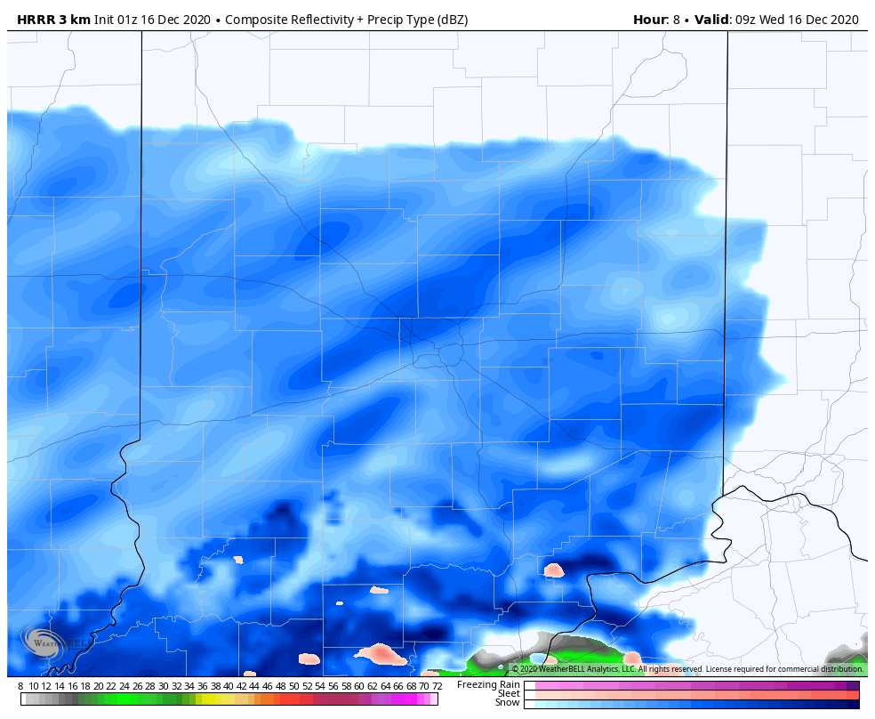
Summary: There’s not a lot much more to add to our client brief tonight from what we’ve been sharing since Saturday morning. This is a system that has behaved as expected throughout and will make a mess of things prior to sunrise Wednesday. While not a blockbuster event by any means, locally, a steady and persistent snow will fall through the majority of our Wednesday. Snow should pull east of the region after sunset Wednesday (5-6p west to 7-8p east). Temperatures will then fall into the middle to upper 20s Wednesday night and Thursday morning helping to allow refreezing on area roadways, and subsequent slick conditions in spots.
The pattern remains quite active into Christmas week. Our evening video package has more details around that below.
You must be logged in to view this content. Click Here to become a member of IndyWX.com for full access. Already a member of IndyWx.com All-Access? Log-in here.
Permanent link to this article: https://indywx.com/video-snow-overspreads-the-region-overnight-and-leads-to-a-slick-time-of-things-wednesday-colder-trends-develop-christmas-to-new-years/
Wind: NE 10-20 MPH early in the event, shifting to the NW and decreasing to 5-10 MPH Wednesday
Blowing/ Drifting: Minimal
Pavement Impacts: Salting and plowing required
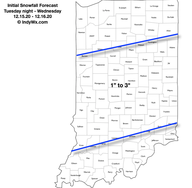
Summary: We don’t see any need to change our early stand on this event (originally issued Saturday morning). Data over the weekend trended away from the heavier snowfall amounts falling across our area only to have moved back to the snowy idea over the past 12-24 hours. Though while never expected to be a blockbuster event here, we always felt this was a classic setup to produce widespread accumulating snows across the region. The snow shield will lift northeast across the region overnight Tuesday into predawn Wednesday. We expect an arrival into the Indy metro and surrounding ‘burbs between 1a (southwest) and 3a (northeast). Once the snow arrives, it’ll settle in for the long haul, continuing (light to moderate intensity) for the better part of the daytime hours. Unfortunately, we fully expect slick roadways for the Wednesday morning rush. The snow will eventually end (southwest to northeast) between 3p and 7p Wednesday. We have no changes to our initial snowfall map below, first issued Saturday morning.
Permanent link to this article: https://indywx.com/client-brief-widespread-snow-builds-in-overnight-tuesday-wednesday-slippery-travel-expected-wednesday-am/