Thursday Forecast: Overall Warm Pattern Continues

Updated 09.25.13 @ 4:48p Zionsville, IN Our overall warm pattern will continue through the upcoming period. Unfortunately, we’re talking about a rather dry time of things, as well! Dry &…

You must be logged in to view this content. Click Here to become a member of IndyWX.com for full access.  Already a member of IndyWx.com All-Access?  Log-in here.

Permanent link to this article: https://indywx.com/2013/09/25/thursday-forecast-overall-warm-pattern-continues/

Wednesday Forecast: Pleasant Early Fall Weather; Sharp Temperature Fall Sunday

Updated 09.24.13 @ 4:48p Zionsville, IN Our stretch of beautiful, uneventful, weather will continue straight on into the weekend. We’re monitoring a system that looks to continue to stay south…

You must be logged in to view this content. Click Here to become a member of IndyWX.com for full access.  Already a member of IndyWx.com All-Access?  Log-in here.

Permanent link to this article: https://indywx.com/2013/09/24/wednesday-forecast-beautiful-early-fall-weather-sharp-temperature-fall-sunday/

Tuesday Forecast: Beautiful Early Fall Weather; Mid Week System Stays South

Updated 09.23.13 @ 8:26p Zionsville, IN The official fall season (meteorological fall began September 1st) couldn’t have gotten off to a more beautiful start! The late week rains cleared out…

You must be logged in to view this content. Click Here to become a member of IndyWX.com for full access.  Already a member of IndyWx.com All-Access?  Log-in here.

Permanent link to this article: https://indywx.com/2013/09/23/tuesday-forecast-beautiful-early-fall-weather-mid-week-system-stays-south/

Mid-Range Pattern: Using The Pacific As Guidance Closer To Home

We wanted to take the time to explain why we look at the Pacific as “guidance” for sensible weather here on the home front, particularly this time of year, in…

You must be logged in to view this content. Click Here to become a member of IndyWX.com for full access.  Already a member of IndyWx.com All-Access?  Log-in here.

Permanent link to this article: https://indywx.com/2013/09/22/mid-range-pattern-using-the-pacific-as-guidance-closer-to-home/

Friday Forecast: Showers & Storms Today; Fall-Like Weekend

Updated 09.19.13 @ 4:48p Zionsville, IN Officially, Indianapolis recorded over one and one half inches of rain Thursday (1.53″ as of 5pm), which was the most in a 24 hour…

You must be logged in to view this content. Click Here to become a member of IndyWX.com for full access.  Already a member of IndyWx.com All-Access?  Log-in here.

Permanent link to this article: https://indywx.com/2013/09/19/friday-forecast-showers-fall-like-weekend/

September: A Look Where We’ve Been & Where We May Be Going…

Ah, September in Indiana… September is typically a month that features wild temperature swings. The fleeting days of summer still have just enough ‘umph left to provide a couple more…

You must be logged in to view this content. Click Here to become a member of IndyWX.com for full access.  Already a member of IndyWx.com All-Access?  Log-in here.

Permanent link to this article: https://indywx.com/2013/09/17/september-a-look-where-weve-been-where-we-may-be-going/

Tuesday Forecast: A Brilliant Day Ahead!

Updated 09.16.13 @ 10:50p

Zionsville, IN We’ll enjoy a cool and refreshing start to your Tuesday and this is only the beginning of what will be an absolutely “brilliant” weather day here across central Indiana. We discuss increasing warmth, humidity, rain chances, and look ahead to your weekend below!

Capture

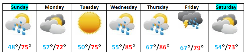
Brilliant Tuesday: The title pretty much sums it up! We look for bright blue skies today and very pleasant temperatures. After a cool and crisp start, temperatures will moderate into the lower 70s for afternoon highs. If you can be outdoors today, make it happen!

Heat and Humidity Increase: A warm front will lift north across the region Wednesday and as this front moves through, look for clouds to increase along with a widely scattered shower or thunderstorm. As of now, we bracket the morning and early afternoon hours Wednesday for the best chance of getting wet, and even that isn’t a great chance. We think only 20%-30% of the viewing area receives rain Wednesday. Otherwise, we’ll feel a much more humid and warmer air mass by the afternoon. This continues Thursday with a scattered shower. Highs Thursday will draw close to 90°.

Friday Cold Front: A cold front will slice into the warm and humid air mass of mid week and this will lead to the best chance of significant, widespread rainfall we’ve seen around these parts in weeks. At this stage, as much as 0.50″-0.75″ looks likely across all of central Indiana Friday as the front moves in. Best chances of getting wet appear to arrive Friday evening (I know, I know…right in the middle of high school football). We’ll continue to monitor.

Cool, Dry Weekend: If you enjoyed last weekend then you’re sure to fall in love with this upcoming weekend. A cooler and drier air mass will move in for the weekend along with lots of sunshine and dry skies.

Permanent link to this article: https://indywx.com/2013/09/16/tuesday-forecast-a-brilliant-day-ahead/

Rambling Around Between Games…

As we alluded to in the post earlier this morning, the weather pattern is beginning to get more active. As “seasoned” Hoosiers know, this is only the beginning of a rather “vamped up” weather period through the next 7-8 months around these parts. Yes, the lazy, hazy days of summer in the weather office are over.  Speaking of the weather office, I’m continuing to get settled into the new “home base” office. As I get settled, more and more products will begin to hit the site to help keep central Indiana Hoosiers abreast of what lies ahead in the weather department.

As we look at the upcoming week, we’ll note the trough and dominant northwesterly flow of the weekend begins to “relax” by mid week and weak ridging takes it’s place. This will lead to a warmer and more muggy (though nothing close to as oppressive as last week) feel to the air by mid week. We also note another dip in the jet by next weekend. While details still have to be ironed out, there’s a good shot of rain due in here by week’s end along with another cool down by next weekend. I also want to point out the re-curving typhoon out in the western Pacific.  This is in association with upper level ridge placement in the Pacific Ocean and we can actually use this tool to help us forecast weather here on the “home front” in the 6-10 day period. That would bring us roughly to 09.25.13 (give or take a couple of days) and would line up nicely with the cool end of the month we’ve been talking about for some time.  Recall that we’ve said we anticipate a warmer than normal month to continue (in the overall pattern sense) up until the last 5-7 days of the month. Does this help set the stage for a colder than average October ahead? Stay tuned…

Here’s a look at our precipitation outlook, compiled this afternoon using a variety of short and mid range forecast models.

precip

Watch how the troughs (cooler air) and ridging (warmer air) correlate with the temperature pattern in our official forecast (posted earlier this morning).

Monday

mondayjet

Wednesday

wednesdayjet

 Friday

fridayjet

Saturday

saturdayjet

Permanent link to this article: https://indywx.com/2013/09/15/rambling-around-between-games/

Sunday Forecast: Turning More Active

Updated 09.15.13 @ 9:26a

Zionsville, IN After a cool and refreshing weekend, a more active weather pattern lies ahead for the upcoming week!

Capture

Finishing Up The Weekend Nicely:  It’s a chilly start to your day across central Indiana. We note several communities down into the 40s again this morning.  Certainly this weekend has gotten many into the fall mood (myself included).  We’ll finish up the weekend nicely with dry skies and highs reaching the middle 70s. It’ll be very pleasant for you tailgaters out there!  We’ll notice increasing cloudiness through the day and a broken line of showers (perhaps a rumble of thunder) will move through central Indiana tonight into the wee morning hours Monday. Rainfall numbers aren’t impressive with this weather maker, as most should see a tenth to a quarter inch of rain on average.

Dry and Pleasant: A dry, pleasant air mass will build in on Monday. Early clouds and any left over rainfall should exit during the morning hours with sunshine building in during the afternoon. Tuesday looks very nice with sunny skies and very comfy’ temperatures!

Turning More Active:  We’ll turn up the thermometer and humidity levels for the middle and latter portion of the week as our dominant air flow shifts around to the southwest in advance of our next (more significant) weather maker. With the increasing humidity, scattered showers and thunderstorms will return to the forecast as early as Wednesday and Thursday, with more widespread shower and thunderstorm activity expected as a cold front gets closer to the region. In fact, we think as much as one half to three quarters of an inch of rain is possible on Friday, in association with this cold front. As the front passes the region, cool high pressure will build back in setting the stage for another delightful, early fall like weekend!

Follow us on Twitter: @IndyWx

Friend us on Facebook: search IndyWx.com

Permanent link to this article: https://indywx.com/2013/09/15/sunday-forecast-turning-more-active/

Wetter Pattern Looming?

Short term drought conditions continue to expand and worsen for many communities across central Indiana. From an agricultural stand point, negative impacts (slightly to moderately so) are being experienced on…

You must be logged in to view this content. Click Here to become a member of IndyWX.com for full access.  Already a member of IndyWx.com All-Access?  Log-in here.

Permanent link to this article: https://indywx.com/2013/09/13/wetter-pattern-looming/

IndyWx.com