About As Quiet As It Can Get…March couldn’t feature any quieter conditions to open up the month. It’s almost eerily quiet… High pressure will dominate our weather and supply an extended stretch of dry conditions. We’ll “flirt” with milder air Wednesday before a brief setback to close the week. Then, it’s off to the races next week, including several days that should go well into the 60s!
The next chance of meaningful precipitation doesn’t appear to be on the horizon until early to middle parts of next week.
Averages: H: 45°/ L: 28° on the 1st –> H: 48°/ L: 30° on the 8th
You must be logged in to view this content. Click Here to become a member of IndyWX.com for full access. Already a member of IndyWx.com All-Access? Log-in here.
II. Eastern, Southeastern regions cool late in the period
Overall, over the upcoming 7-day period, above normal temperatures are expected from the northern Plains into the Southeast, including OHV.
Precipitation is expected to run above normal across the Southeast, TN Valley, and lower OHV.
Rainfall should run between 0.75″ and 1.25″ for central IN over the upcoming 7-days.
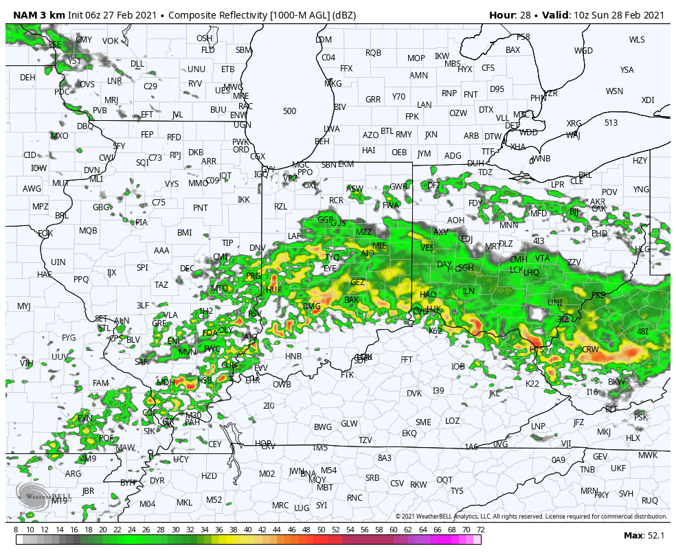
There is a threat of severe weather today from the Ark-la-tex region into the western TN Valley.
Widespread significant drought continues across the West, especially Southwest/ Four-Corners region.
Forecast period: 02.28.21 through 03.07.21
The short-term will be dominated by a the wet (and stormy for some) time of things from the OH Valley, but more so centered in the TN River Valley. Eventually the associated frontal boundary will sweep into the Southeast region early in the work week before stalling out and serving as the focal point for additional storm systems mid and late week. The first of these systems will scoot from the southern Plains east into the Southeast in the Monday through Wednesday time period with additional opportunities for heavy rain and local severe weather. We’ll watch for another suppressed system late in the week that will likely take a similar route in the Thursday-Saturday timeframe.
From a central Indiana standpoint, best rain chances out of the entire period are in front of us now. Things should dry out considerably through the balance of the upcoming work week given the overall pattern.
You must be logged in to view this content. Click Here to become a member of IndyWX.com for full access. Already a member of IndyWx.com All-Access? Log-in here.
Permanent link to this article: https://indywx.com/video-analyzing-latest-short-term-heavy-rain-trends-guidance-trends-colder-for-the-eastern-seaboard-days-5-10/
While we’re dealing with areas of light rain early this morning, most of our Saturday will be precipitation-free. That will all begin to chance during the overnight and predawn hours Sunday. Computer model guidance has begun to trend north with the heavy rain axis during this time frame. Southern portions of the state will still get in on the heavy rain show, but it now appears as if there will be a window for heavy rain across more of central Indiana in the 2a-9a window Sunday.