Quiet Open To The Week Turns Busy; Focus Shifts To Late Week HVY Rain Threat…

Updated 03.18.23 @ 2:33p

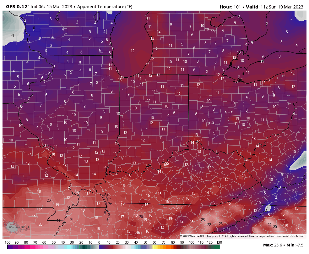
The short-term pattern will be highlighted by today’s wintry conditions. Snow showers accompanied bitter cold (at least by March standards) this morning, including wind chill values that even dipped below zero in spots. Sunday will also feature unseasonable cold before a slow moderation in the temperature department eventually takes us back into the 60s by midweek.

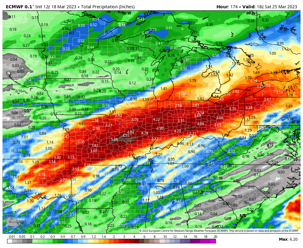
Speaking of midweek, that’s when unsettled weather will return. We don’t anticipate particularly heavy rain, but rain chances will be on the increase Wednesday. Early numbers suggest we’re looking at 0.25” to 0.50” type of an event but this appears to set the stage for a more significant rain storm as we get set to close the week. As is typically the case 5-6 days out, forecast models differ on the specifics but the overall pattern favors a heavy rain and local flood threat unfolding across the Ohio Valley. Specifics regarding whether or not this is a central or more of a southern OHV threat will be dealt with in the days ahead.

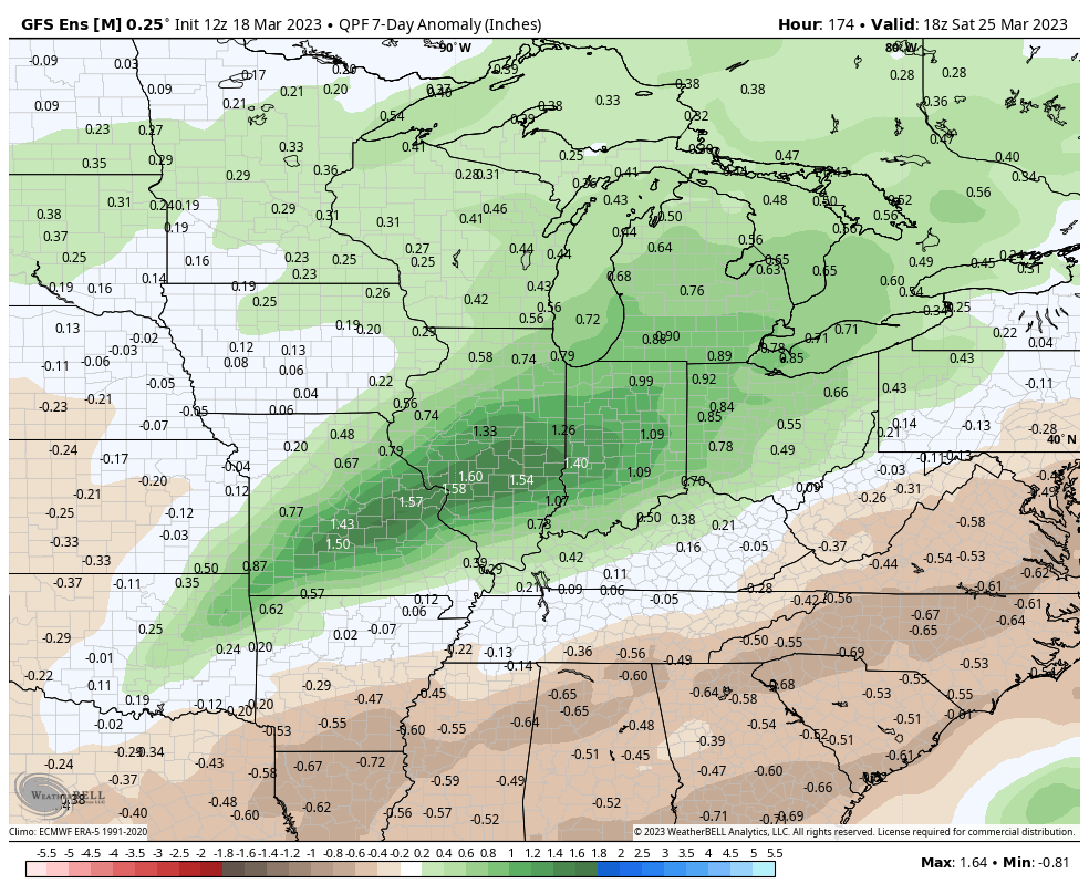
As it is, the GFS and European are in great agreement from this distance on the heavy rain and flood threat, including the opportunity of 3”+ of rain through at least a portion of the forecast area (most of which falls Friday). Specifics around more details with locations/ rainfall numbers will be fine tuned in the days ahead.

Permanent link to this article: https://indywx.com/quiet-open-to-the-week-turns-busy-focus-shifts-to-late-week-hvy-rain-threat/

Long Range Update To Close Out March And Open April…

Updated 03.17.23 @ 6a

You must be logged in to view this content. Click Here to become a member of IndyWX.com for full access.  Already a member of IndyWx.com All-Access?  Log-in here.

Permanent link to this article: https://indywx.com/long-range-update-to-close-out-march-and-open-april/

VIDEO: Wet, Windy Weather Returns By Evening; Cold Weekend On Tap…

Updated 03.16.23 @ 7:32a

You must be logged in to view this content. Click Here to become a member of IndyWX.com for full access.  Already a member of IndyWx.com All-Access?  Log-in here.

Permanent link to this article: https://indywx.com/video-wet-windy-weather-returns-by-evening-cold-weekend-on-tap/

Unsettled Close To The Work Week; Cold Weekend On Tap…

Updated 03.15.23 @ 6:58a

Let’s start with the good news and that’s today’s forecast. Despite a bitterly cold start (most are waking up to temperatures between 18° and 22°), expect plentiful sunshine today. Though it’ll be unseasonably chilly, that March sun angle will go a long way in making it feel a lot better by this afternoon.

Clouds will increase overnight and Thursday morning and eventually give way to light rain by afternoon. We anticipate rain to reach the city, itself, between 2p and 3p.

Rain will become steadier and more widespread as we progress through the evening and Thursday night.

Precipitation may end as a brief period of snow Friday morning, but “brief” is the key word. In general, heaviest rain is expected to fall across the southern half of the state, mostly along and south of the I-70 corridor. This is a 0.25” to 0.75” type event for most.

The bigger story comes in the form of another late season arctic “jab” behind the frontal passage. Highs both Saturday and Sunday will remain stuck in the 30s with overnight lows once again dropping into the upper 10s to lower 20s. Wind chill values will fall into the single digits to lower 10s.

Permanent link to this article: https://indywx.com/unsettled-close-to-the-work-week-cold-weekend-on-tap/

VIDEO: Cold Air Reinforcements Just In Time For The Weekend…

Updated 03.14.23 @ 6:04a

You must be logged in to view this content. Click Here to become a member of IndyWX.com for full access.  Already a member of IndyWx.com All-Access?  Log-in here.

Permanent link to this article: https://indywx.com/video-cold-air-reinforcements-just-in-time-for-the-weekend/