
You must be logged in to view this content. Click Here to become a member of IndyWX.com for full access. Already a member of IndyWx.com All-Access? Log-in here.
Permanent link to this article: https://indywx.com/2020/01/17/video-short-term-update-on-tonights-sleet-and-freezing-rain/
Jan 17
Client Brief: Wintry Mix Arrives This Evening; Slick Travel Expected Across A Portion Of The Region…
Type: Impactful Wintry Weather
What: Coating of snow and light glaze of ice
When: This evening into tonight
Temperatures: Upper 20s to around 30° before rising into the upper 30s after sunrise
Wind: Southeast tonight 20-30 MPH, shifting to the south Saturday morning and gusting to 40 MPH before shifting to the west behind the cold front Saturday evening.
Blowing/ Drifting: Non-existent
Pavement Impacts: Salting will be required today.

An area of low pressure will track across the central Plains today into the lower Great Lakes and into New England Saturday into Sunday. An associated cold front will sweep through the region Saturday PM resulting in a return of very cold air Saturday night into early next week.
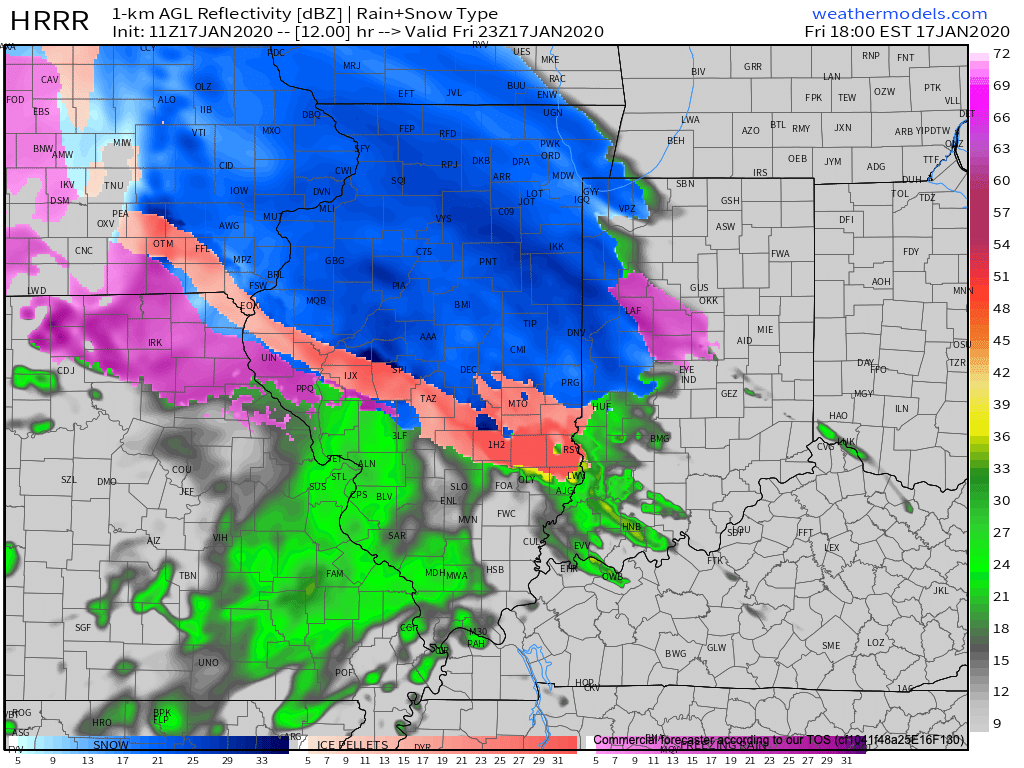
The majority of the day will remain precipitation-free across the state with a lowering and thickening cloud deck by afternoon. As our attention shifts to late afternoon and evening, an initial burst of snow will make it’s way into west-central Indiana (around Terre Haute) before arriving into the city, itself, towards 6p to 7p. For a good chunk of central Indiana, this snow will transition rather quickly to a mix of sleet and freezing rain as evening gives way to nighttime. In and around Indianapolis and northern suburbs, expect a snow/ sleet accumulation of up to 1″ followed by a light glaze of ice. Further north, snow will hang on longer as the predominant precipitation type, resulting in accumulations of 2″ to 4″. If traveling this evening into tonight, icy roads are likely across central Indiana. Temperatures will warm above freezing prior to sunrise Saturday with significant improvement expected on area roadways. This will help precipitation transition to a cold rain Saturday morning before a cold front whips across the state and sends temperatures into a nose dive Saturday evening. Gusty winds will accompany this frontal passage (40 MPH gusts) and any leftover moisture will refreeze Saturday evening resulting in patchy black ice issues on untreated surfaces.
Confidence: High
Next Update: Tonight
Permanent link to this article: https://indywx.com/2020/01/17/client-brief-wintry-mix-arrives-this-evening-slick-travel-expected-across-a-portion-of-the-region/
Jan 16
Wintry Mix Tomorrow Evening; Fresh Long Range Fun…
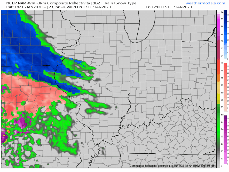
Friday will dawn dry, but the mid and high level cloud canopy will be a sign of things to come. These clouds will lower and thicken through the day and eventually give way to a wintry mix by evening. While there may initially be a period of snow (especially north of Indianapolis), the majority of the “overrunning” precipitation should fall as a mixture of sleet and freezing rain. In and around Indianapolis and points north, a light “glaze” of ice is possible Friday evening of up to .10″ (after the possibility of a coating of snow).
Dry air will likely have to be overcome at first, but a burst of snow is possible into the city around 5p to 6p before the transition over to the sleet and freezing rain mixture. Eventually, the icy mixture will transition to a cold rain prior to sunrise Saturday.
MUCH colder air will pour into the state Saturday evening with temperatures falling into the 10s prior to midnight Sunday morning and wind chills into the single digits.

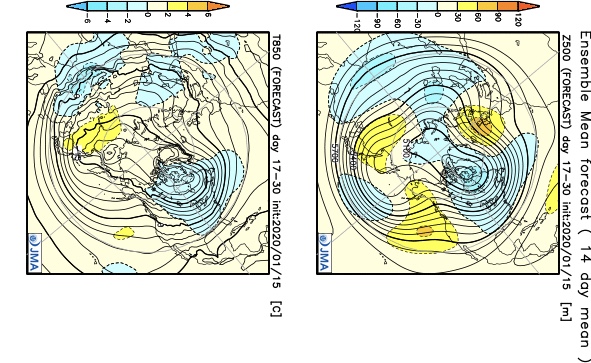
As we look longer term, we don’t see any reason to alter our ongoing thoughts of a colder pattern taking hold, overall, over the upcoming 10-14 day period (and likely into the first half of Feb.). We’ve covered our reasoning in previous posts (Phase 7 of the MJO, positive PNA, neutral EPO, etc.). What’s interesting to note is the rather stark difference in the handling of the EPO between the negative GEFS and positive EPS. The likely end result will be somewhere in between; hence our neutral EPO forecast. At the end of the day, it’s really not the EPO, PNA, or NAO that will drive the mean pattern, but the MJO. And with that said, Phase 7 of the MJO features a cold, stormy look.

The high latitude blocking screams for an active storm track across our neck of the woods (as does the slightly positive PNA and neutral EPO). Sure enough, the latest modeling is going towards this stormy look (active southern stream) in the medium to long range period.
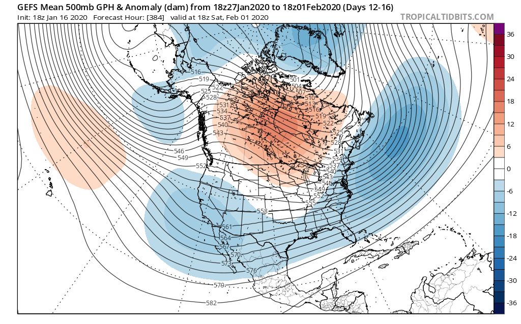
A great mentor once taught me to always be leery of ridges over Hudson Bay in the winter time. Time and time again, this pattern setup results in fairly widespread winter storm events through the Lower 48 and we think there is increased potential in this sometime during the Jan. 25-31 time period. While there’s no way to be specific, just keep a mental note in the back of your mind for this threat.
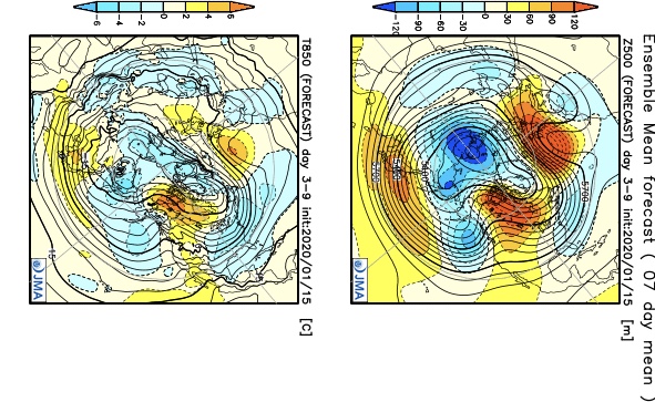
In closing, a review of the latest JMA Weeklies shows a significantly different pattern than what we’ve grown accustomed to as of late taking up residence through the bulk of the upcoming 3-4 weeks. Given the above, it would be tough to argue this look…

Fresh video update will hit in the AM with new thoughts around tomorrow evening’s winter weather maker.
Permanent link to this article: https://indywx.com/2020/01/16/wintry-mix-tomorrow-evening-fresh-long-range-fun/
Jan 16
VIDEO: Timing The Arrival Of Precipitation Friday; MUCH Colder Air Moves In…
You must be logged in to view this content. Click Here to become a member of IndyWX.com for full access. Already a member of IndyWx.com All-Access? Log-in here.
Permanent link to this article: https://indywx.com/2020/01/16/video-timing-the-arrival-of-precipitation-friday-much-colder-air-moves-in/
Jan 15
First Comes The Cold, Then Come The Storms…
You must be logged in to view this content. Click Here to become a member of IndyWX.com for full access. Already a member of IndyWx.com All-Access? Log-in here.
Permanent link to this article: https://indywx.com/2020/01/15/first-comes-the-cold-then-come-the-storms/
Jan 15
VIDEO: Late Week Storm; Much Colder Next Week…
You must be logged in to view this content. Click Here to become a member of IndyWX.com for full access. Already a member of IndyWx.com All-Access? Log-in here.
Permanent link to this article: https://indywx.com/2020/01/15/video-late-week-storm-much-colder-next-week/
Jan 14
VIDEO: Friday-Saturday Storm; Leaning On The MJO In The Long Range…
You must be logged in to view this content. Click Here to become a member of IndyWX.com for full access. Already a member of IndyWx.com All-Access? Log-in here.
Permanent link to this article: https://indywx.com/2020/01/14/video-friday-saturday-storm-leaning-on-the-mjo-in-the-long-range/
Jan 14
Tuesday Morning Rambles: Weak Midweek System Followed By Another Strong Late Week Storm…
1.) Patchy fog will burn off to another day with mostly cloudy conditions (should see a bit more sunshine than we saw on Monday) and mild temperatures. Mid 30s will warm into the lower 50s today and middle 50s Wednesday. The downside to Wednesday’s mild air? Light rain will scoot across the state. “Light” is the key word with amounts of a trace to under 0.10″.


2.) A cold front will push south across the region Wednesday evening and result in colder conditions (but with increased sunshine) Thursday. Highs in the lower to middle 30s can be expected across central Indiana Thursday.

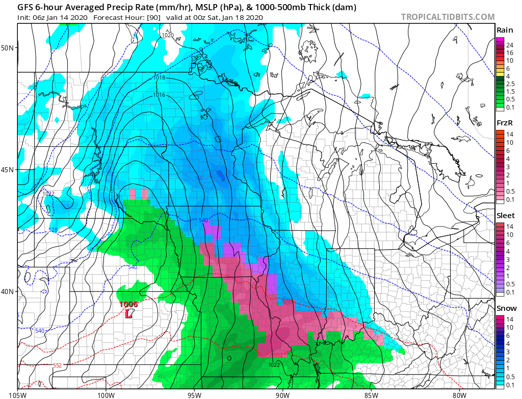
3.) As we move into late week, a stronger storm system will impact the area. Low pressure will develop along the lee of the Rockies Friday morning before tracking into the lower Great Lakes Saturday morning and into New England Sunday. With marginally cold air in place Friday (courtesy of Wednesday evening’s cold front), “overrunning” precipitation should fall as a wintry mix of snow and sleet Friday afternoon. While still early, it’s possible a quick couple inches of snow and sleet make travel messy Friday PM (worth keeping a close eye on) before precipitation changes to a cold rain Friday night into the predawn Saturday. Eventually, as the cold front whips across the state, colder air will return Saturday morning and precipitation will end as snow showers.
4.) The previously mentioned storm system will usher more of a prolonged wintry pattern back into the eastern portion of the country. As we look ahead through the remainder of the month, below normal temperatures are expected to carry the day, along with the threat of additional wintry precipitation from time to time. This is the kind of pattern that will certainly promote storms and “rumors of storms” and it’ll be important to remain locked into the forecast as we put a close on January.

Permanent link to this article: https://indywx.com/2020/01/14/tuesday-morning-rambles-weak-midweek-system-followed-by-another-strong-late-week-storm/
Jan 13
VIDEO: Relatively Quiet Open To The Work Week; Big “Problematic” Late Week Storm…
You must be logged in to view this content. Click Here to become a member of IndyWX.com for full access. Already a member of IndyWx.com All-Access? Log-in here.
Permanent link to this article: https://indywx.com/2020/01/13/video-relatively-quiet-open-to-the-work-week-big-problematic-late-week-storm/
Jan 12
VIDEO: Week-Ahead Outlook And More On The Pending Pattern Change…
You must be logged in to view this content. Click Here to become a member of IndyWX.com for full access. Already a member of IndyWx.com All-Access? Log-in here.
Permanent link to this article: https://indywx.com/2020/01/12/video-week-ahead-outlook-and-more-on-the-pending-pattern-change/
IndyWx.com 7-Day Outlook: Central Indiana

Central Indiana Radar
