Burst Of Snow This Afternoon; Storms And “Rumors” Of Storms This Upcoming Week…

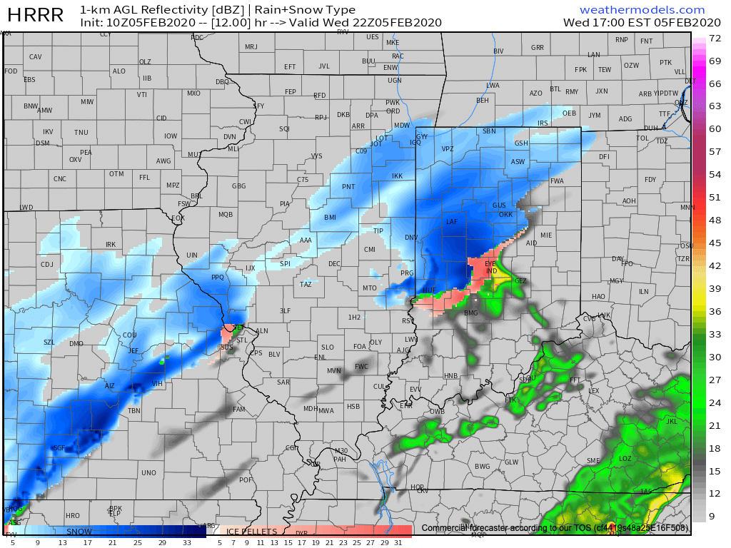
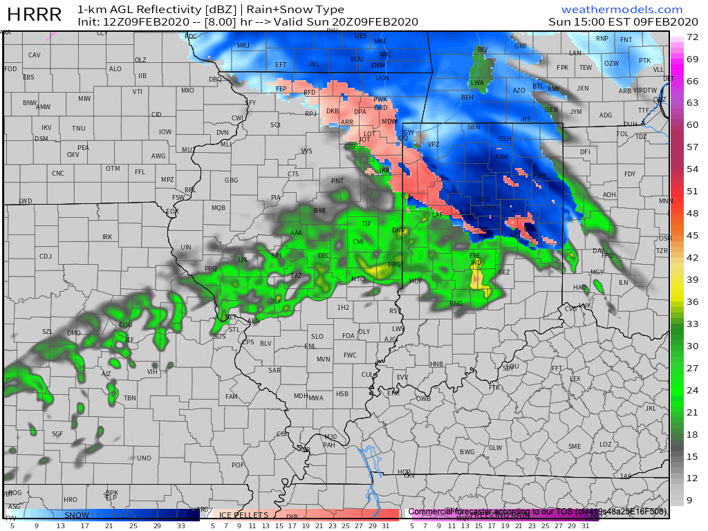
The day is starting off on a cold note with some fog and low clouds around, but at least we’re dry (for now). That will begin to change here in a few hours as a burst of snow moves into the city around lunchtime. A brief period of moderate to heavy snow may whiten the ground just north of the city before a transition to a cold rain for the better part of the afternoon.

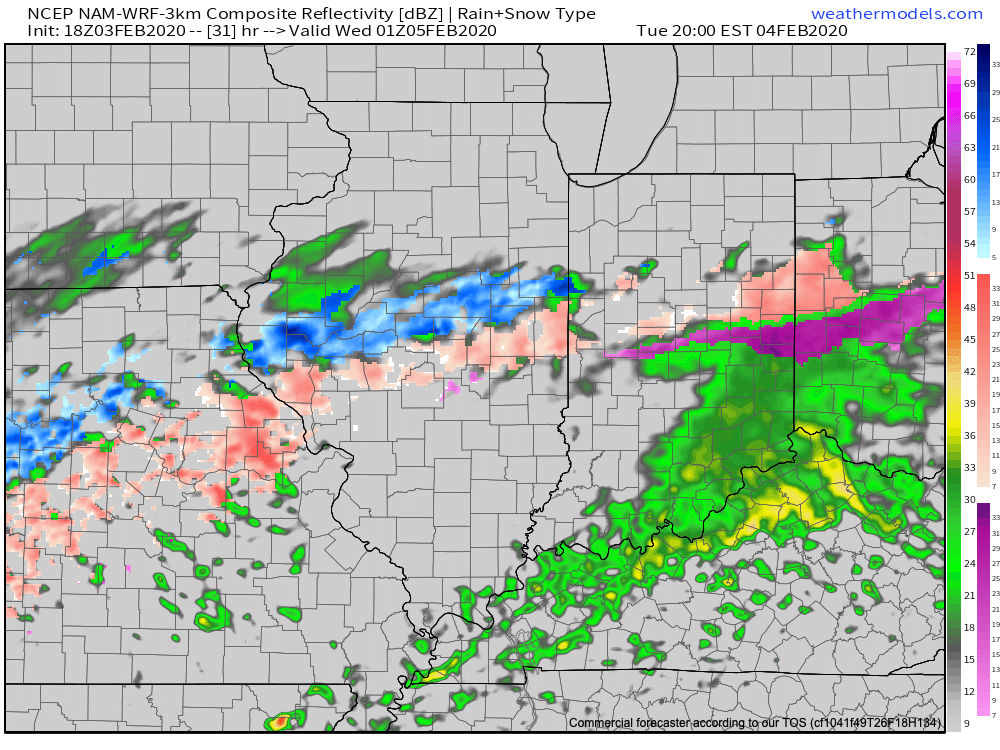
Further north, cold air will hang on longer and a more significant period of snow is expected through the afternoon and early evening. In fact, periods of heavy snow can be expected, including snowfall rates up to 1″ per hour at times. If you have travel plans to places such as Ft. Wayne, South Bend, or Logansport, we’d recommend preparing for slick travel and snow covered roads can be expected. This will be a wet and heavy snow. Pavement impacts will require salting and plowing across the northern 1/3 of the state this afternoon into the evening.

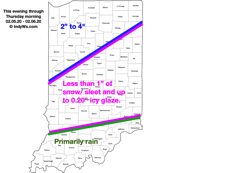
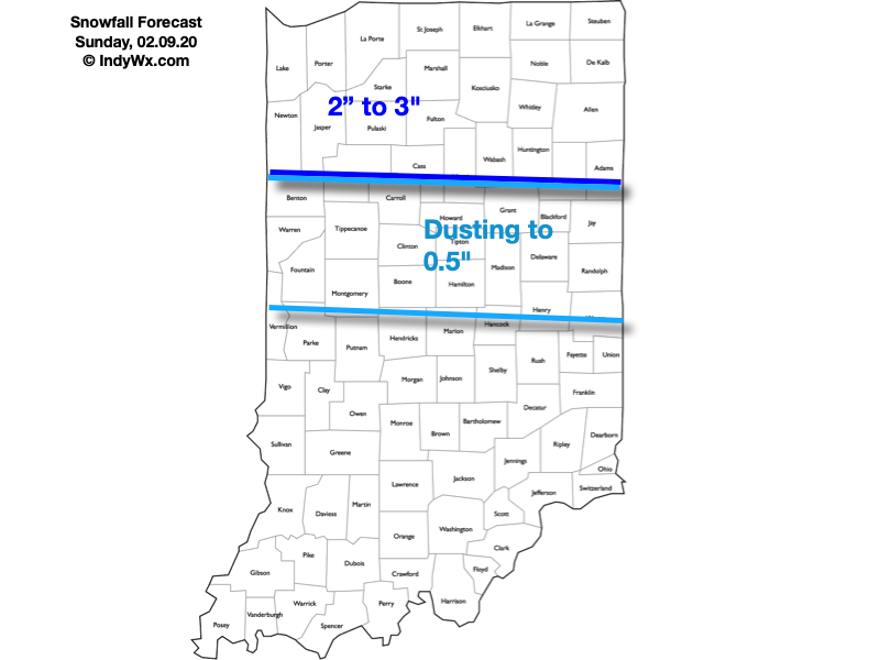
Here’s our snowfall forecast today:

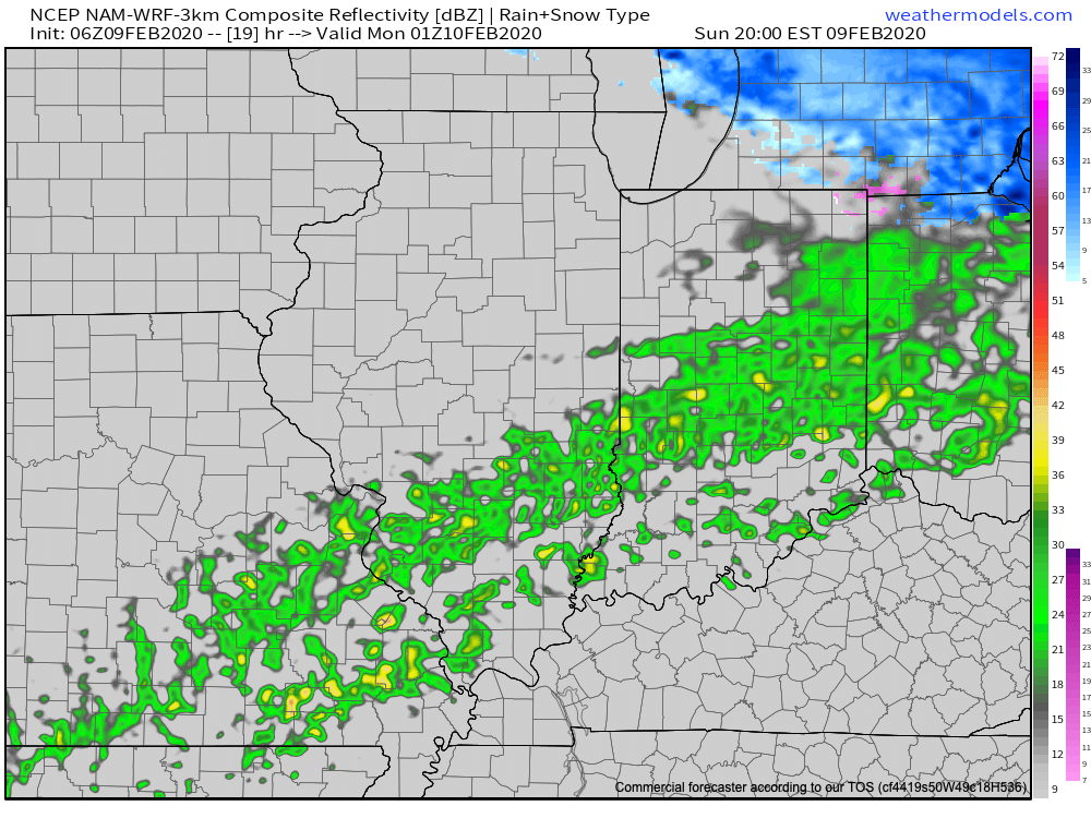
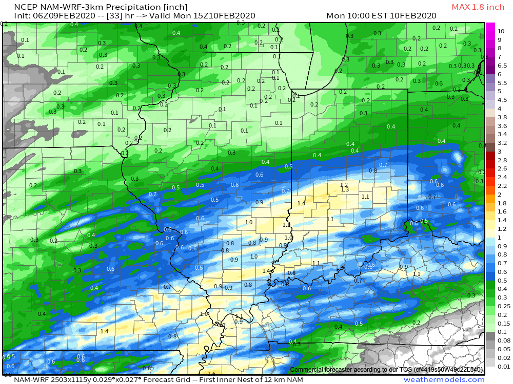
The attention will then shift to a period of moderate to heavy rain through the evening and into the overnight across the I-70 corridor. By the time all is said and done Monday morning, widespread 1″ to 1.5″ is expected with the passage of this storm system. Good news? Most of the rain should be south of our area by the morning rush Monday.

High pressure will then settle into the Ohio Valley as we move into Monday evening and Tuesday, allowing a briefly quieter period of weather to arrive on the scene.

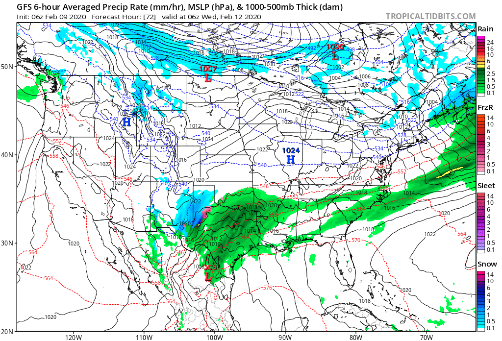
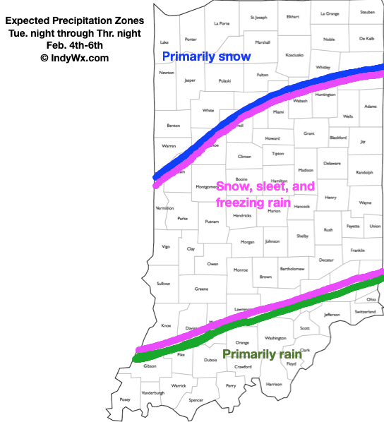
By this time, however, all eyes will shift to the southwest and our next storm system that should be brewing. While models differ on the specifics with this storm, the overall upper pattern suggests we need to remain on our toes with respect for the potential of additional winter weather stretching from the mid-MS Valley Wednesday, Ohio Valley Wednesday night into Thursday, and interior Northeast Thursday into Thursday night. A brief, but potent shot of arctic air would follow to close the work week- especially if we can get some snow down.

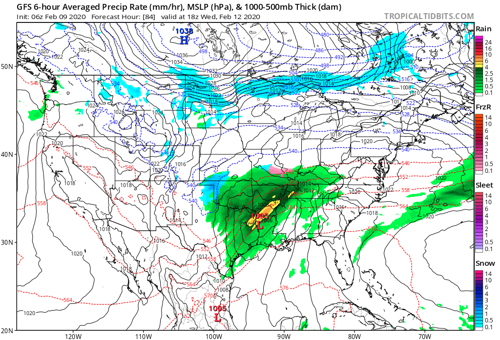
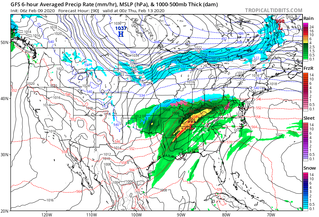
Should snow get laid down with this system across the OHV region, a cold arctic high would be capable of sending temperatures into the single digits to close the work week.

Stay tuned…

Permanent link to this article: https://indywx.com/2020/02/09/burst-of-snow-this-afternoon-storms-and-rumors-of-storms-this-upcoming-week/

VIDEO: Couple Additional Rounds Of Snow This Afternoon-Sunday Afternoon; Looking Ahead At The Upcoming Week…

You must be logged in to view this content. Click Here to become a member of IndyWX.com for full access.  Already a member of IndyWx.com All-Access?  Log-in here.

Permanent link to this article: https://indywx.com/2020/02/08/video-couple-additional-rounds-of-snow-this-afternoon-sunday-afternoon-looking-ahead-at-the-upcoming-week/

VIDEO: Accumulating Snow Impacts The Southern Half Of The State Overnight-Saturday Morning; Looking Ahead To Another Busy Week…

You must be logged in to view this content. Click Here to become a member of IndyWX.com for full access.  Already a member of IndyWx.com All-Access?  Log-in here.

Permanent link to this article: https://indywx.com/2020/02/07/video-accumulating-snow-impacts-the-southern-half-of-the-state-overnight-saturday-morning-looking-ahead-to-another-busy-week/

Long Range Update: Latest EPO/ MJO Implications…

Before we dig into the late-February pattern, there’s no let-up in sight with respect to our current active weather pattern. Just next week alone, we’re tracking (3) systems:

I. Sunday

II. Wednesday

III. Thursday-Friday

This is all part of the big battle taking place between a persistent southeast ridge and western trough. The tight thermal gradient between these features will help “fuel” continued active times, and above average precipitation next week. As mentioned this morning, at times we’ll have to deal with bouts of moderate-heavy rain, and at others, sleet, snow, and freezing rain.

An active weather pattern will continue as the ‘mean’ storm track cuts right through the Ohio Valley next week.

Looking ahead, we continue to build our longer range forecast by using “base ingredients” that feature a 50-50 split of the MJO (Madden Julian Oscillation) and EPO (East Pacific Oscillation).

The MJO maintains a warm look, rolling things into Phase 5-6 over the next few weeks.

As you know by now, these are warm phases- especially across the eastern portion of the country.

The “saving grace” for fans of at least being on the playing field for a chance of wintry weather in such warm MJO phases is the negative EPO. There’s great model agreement that this negative EPO will continue into the middle part of the month and this will keep us on our toes for wintry implications as storms track through the region. Conversely, there’s reason to buy into a “blow torch” regime to close the month, as the EPO flips positive and combines with the Phase 5-6 of the MJO.

To no surprise, given the above, we see the new European Weeklies showing a warming trend (after the fight over the upcoming week) for late-February.

The JMA Weeklies from this morning (for the Weeks 3-4 time frame) would agree.

Permanent link to this article: https://indywx.com/2020/02/06/long-range-update-latest-epo-mjo-implications/

VIDEO: Details On 3 Waves Of Snow Between Now And Saturday…

You must be logged in to view this content. Click Here to become a member of IndyWX.com for full access.  Already a member of IndyWx.com All-Access?  Log-in here.

Permanent link to this article: https://indywx.com/2020/02/06/video-details-on-3-waves-of-snow-between-now-and-saturday/

VIDEO: Short-Term Update Tonight Through Saturday- Ice Gives Way To Snow…

You must be logged in to view this content. Click Here to become a member of IndyWX.com for full access.  Already a member of IndyWx.com All-Access?  Log-in here.

Permanent link to this article: https://indywx.com/2020/02/05/video-short-term-update-tonight-through-saturday-ice-gives-way-to-snow/

Client Brief: Conditions Deteriorate By Late Afternoon…

Type: Impactful Wintry Weather

A wintry mix of sleet and snow will arrive into central IN between 4p and 5p.

What: Accumulating snow, sleet, and freezing rain

When: This evening and Thursday morning

Temperatures: Upper 20s to around 30°

Wind: Northeast 10 to 20 MPH

Blowing/ Drifting: Light to moderate across northern Indiana

Pavement Impacts: Salting/ plowing also will be required in the “snow zone.”

A surface wave will move from the middle MS River Valley into the TN and lower Ohio Valley region tonight and Thursday morning. Eventually this system will push into the Mid-Atlantic states Friday.

After a mostly dry daytime, precipitation will become more widespread by late afternoon and early evening. More specifically, we anticipate a wintry mix of sleet and snow to move into Indianapolis and a greater chunk of central Indiana between 4p and 5p. Waves of moisture will continue to impact the region into tonight, but as warmer air aloft moves overhead, precipitation is expected to transition to a mixture of sleet and freezing rain during this time frame. Up to 2 tenths of an inch of glaze is possible across the I-70 corridor this evening. We recommend avoiding travel if possible tonight across central Indiana with icy spots expected to develop on area roadways. Across most of central Indiana, snow and sleet accumulation should remain less than 1″. Further north, precipitation will remain predominantly snow with 2″ to 4″ expected.

Colder air aloft will return Thursday allowing precipitation to transition back to light snow across central Indiana. As upper level support swings through the state, snow should become more widespread Thursday night into Friday morning with additional light accumulation possible.

Confidence: High

Next Update: This evening

Permanent link to this article: https://indywx.com/2020/02/05/client-brief-conditions-deteriorate-by-late-afternoon/

VIDEO: Fresh Data In On Wednesday Night; New Thoughts On This Weekend’s Accumulating Snow Threat…

You must be logged in to view this content. Click Here to become a member of IndyWX.com for full access.  Already a member of IndyWx.com All-Access?  Log-in here.

Permanent link to this article: https://indywx.com/2020/02/04/video-fresh-data-in-on-wednesday-night-new-thoughts-on-this-weekends-accumulating-snow-threat/

VIDEO: Detailed Look At Multiple Rounds Of Wintry Precipitation, Including An Icy Set-Up Tomorrow Evening…

You must be logged in to view this content. Click Here to become a member of IndyWX.com for full access.  Already a member of IndyWx.com All-Access?  Log-in here.

Permanent link to this article: https://indywx.com/2020/02/04/video-detailed-look-at-multiple-rounds-of-wintry-precipitation-including-an-icy-set-up-tomorrow-evening/

Client Brief: Multiple Rounds Of Wintry Precipitation Expected Tuesday Night-Thursday Night…

Type: Impactful Wintry Weather

A wintry mix will begin to impact parts of central IN as early as Tuesday evening.

What: Potential of accumulating snow, sleet, and freezing rain

When: Multiple rounds:

I. Tuesday evening through Wednesday morning

II. Wednesday evening through Thursday evening

Temperatures: Upper 20s to lower 30s

Wind: Northeast 20 to 30 MPH and gusty Tuesday night, shifting to the north, northwest 5 to 15 MPH Wednesday night into Thursday.

Blowing/ Drifting: Non-existent

Pavement Impacts: Salting/ plowing also will likely be required in the “snow zone.”

A complex weather pattern will result in a multitude of precipitation types across the state in the Tuesday night through Thursday night time period. Here’s our early thinking where we think the various types of precipitation setup shop:

As we time things out, rain is expected to overspread most of the state Tuesday morning. Heaviest and most concentrated rainfall should occur along and south of the I-70 corridor. A downright balmy start to the day will trend significantly colder (especially around and after lunchtime). As cold air continues to ooze south, renewed precipitation is expected to break out Tuesday evening into Wednesday morning, courtesy of a wave moving along the cold front. With colder air in place, this precipitation is expected to primarily fall in the form of sleet and freezing rain through the “heart” of central Indiana with snow across northern parts of the state. With temperatures falling below freezing Tuesday evening, slick spots on area roadways are anticipated to develop- even despite the recent warm weather of the past couple of days.

Most of the daytime should feature a relative “lull” in the precipitation with nearly steady temperatures across central and northern Indiana (around or just below freezing). The briefly quiet times will give way to another round of more widespread and heavier precipitation Wednesday evening, continuing into the day Thursday as a stronger wave of low pressure moves northeast from northern MS, along the Ohio River, and into eastern Ohio. Like what we’ll experience tomorrow evening, the precipitation forms will vary significantly based on your locale. We think another round of sleet (perhaps some freezing rain across south-central Indiana) will dominate across central Indiana, with primarily snow across northern Indiana. Within the highlighted “snow zone,” amounts of 3″ to 6″ certainly seem possible by the time all is said and done Thursday evening.

Confidence: Medium

Next Update: Tuesday morning

Permanent link to this article: https://indywx.com/2020/02/03/client-brief-multiple-rounds-of-wintry-precipitation-expected-tuesday-night-thursday-night/

IndyWx.com