
You must be logged in to view this content. Click Here to become a member of IndyWX.com for full access. Already a member of IndyWx.com All-Access? Log-in here.
Permanent link to this article: https://indywx.com/2020/03/11/video-storms-to-snow-long-range-update-into-late-march/
Mar 10
Very Active Pattern Looms For Mid And Late March…
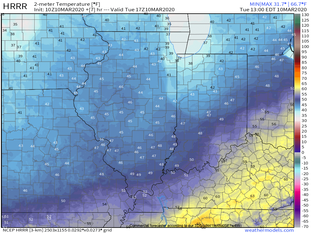
Before we get into the longer range weather pattern, rain this morning has been locally heavy in spots. Moving forward today, that rain will push east of the state and we’ll turn cooler. Temperatures will settle into the middle to upper 40s this afternoon across central Indiana.
Another couple of weak systems will scoot through the area as we push through the remainder of the work week. The first, tomorrow, will impact areas primarily to our north, however, a cold front will sweep through the state Thursday night and early Friday with light rain and an abrupt wind shift to the northwest. Rainfall amounts with the passage of this cold front should average only between a trace and 0.05″.
A third system will push east across the TN Valley Saturday into early Sunday. With marginally cold air in place across the Ohio Valley, precipitation may transition to wet snow or a mix of rain and snow along the I-70 corridor during this time frame. The northward extent of the precipitation shield is in question and we’ll have to keep a close eye on this system over the next couple of days.
As we look longer term, a tight thermal gradient is expected to setup shop across our region. This will force a cold pattern across the west with eastern seaboard warmth. We’ll be in that “back and forth” battle zone of sorts, locally.
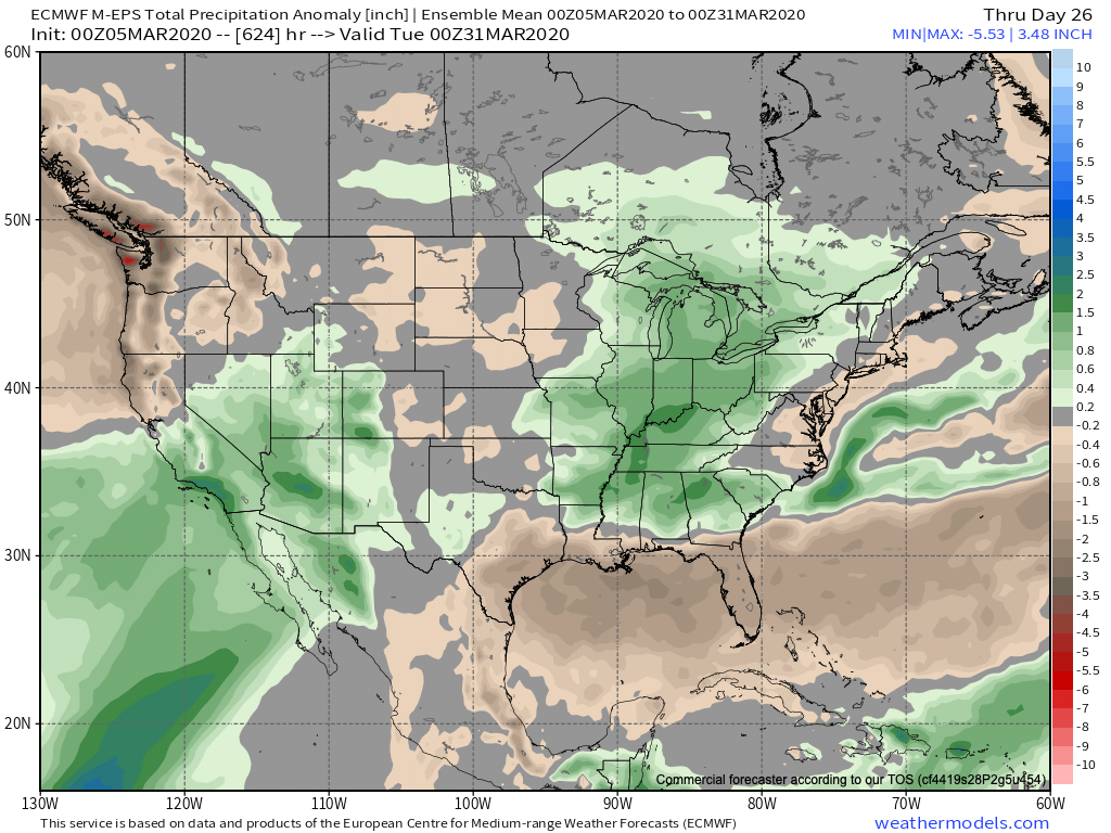
What this will also do is help assist in a hyper storm track through the MS River Valley and Ohio Valley. Above to well above average precipitation is expected during the middle and latter part of March across our region.

Unfortunately, local landscaping companies, turf management, farmers, and others with ag interests are likely to experience delays as we move through the 2nd half of March and into early April.
Permanent link to this article: https://indywx.com/2020/03/10/very-active-pattern-looms-for-mid-and-late-march/
Mar 09
VIDEO: Week-Ahead Outlook; Deeply Negative EPO Creates Interesting Times Mid-Month…
You must be logged in to view this content. Click Here to become a member of IndyWX.com for full access. Already a member of IndyWx.com All-Access? Log-in here.
Permanent link to this article: https://indywx.com/2020/03/09/video-week-ahead-outlook-deeply-negative-epo-creates-interesting-times-mid-month/
Mar 08
VIDEO: Warm Now, But We’re Likely Not Finished With The Snow Just Yet…
You must be logged in to view this content. Click Here to become a member of IndyWX.com for full access. Already a member of IndyWx.com All-Access? Log-in here.
Permanent link to this article: https://indywx.com/2020/03/08/video-warm-now-but-were-likely-not-finished-with-the-snow-just-yet/
Mar 07
VIDEO: Gorgeous Weekend; Discussing Timing Of Systems Next Week And Longer Range Impacts Of The MJO/ EPO…
You must be logged in to view this content. Click Here to become a member of IndyWX.com for full access. Already a member of IndyWx.com All-Access? Log-in here.
Permanent link to this article: https://indywx.com/2020/03/07/video-gorgeous-weekend-discussing-timing-of-systems-next-week-and-longer-range-impacts-of-the-mjo-epo/
Mar 06
Long Range Update: Active Mid-March Storm Track…
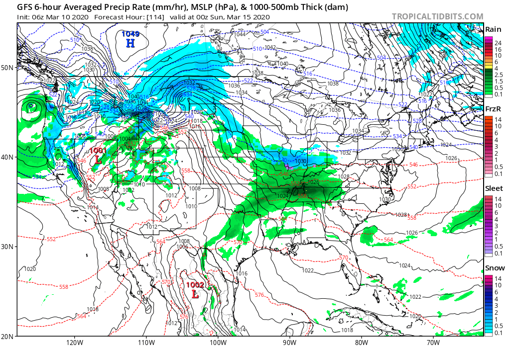
After a relatively quieter stretch of weather as of late, all signals ahead point towards an increasingly busy time of things over the upcoming couple of weeks. After (2) systems that will track in more of west-east fashion across the Ohio Valley during the 1st half of next week, the mean storm track will shift towards one that features low pressure systems moving out of the south-central Plains into the western Great Lakes thereafter.
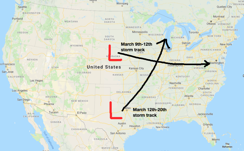
What this will do is replace a couple of systems (the mid-week one likely to still dish out wintry precipitation across the northern Ohio Valley/ Great Lakes region) during the first half of next week that feature cooler air and lighter rain with a more traditional spring flavor. The storm systems that impact our area during the mid-March time period will include heavier rain potential, along with warmer/ more humid air and the risk of stronger storms.
Just in the next 2 weeks, we count a total of (5) storm systems that will impact the region. In the face of what the latest JMA Weeklies were trying to suggest around drier conditions, it appears as if our wet March forecast will play out nicely.

Note the longer range computer model guidance from the GEFS and European Weeklies also see the wet anomalies greatest through an area that includes the Ohio Valley.

We’ll also have to begin paying attention to the potential of increased severe weather threats into the Ohio Valley with the expected mid-March storm track.
In the short-term, if you can deal with today’s snow and wintry feel, a gorgeous weekend is dialed up, including plentiful sunshine and quickly moderating temperatures (low 50s Saturday and low 60s Sunday).
More later!
Permanent link to this article: https://indywx.com/2020/03/06/long-range-update-active-mid-march-storm-track/
Mar 05
VIDEO: Wintry Friday Gives Way To A Stunning Weekend…
You must be logged in to view this content. Click Here to become a member of IndyWX.com for full access. Already a member of IndyWx.com All-Access? Log-in here.
Permanent link to this article: https://indywx.com/2020/03/05/video-wintry-friday-gives-way-to-a-stunning-weekend/
Mar 04
VIDEO: Colder Close To The Week Gives Way To A Pleasant Weekend; Wintry Threat For Some Next Week…
You must be logged in to view this content. Click Here to become a member of IndyWX.com for full access. Already a member of IndyWx.com All-Access? Log-in here.
Permanent link to this article: https://indywx.com/2020/03/04/video-colder-close-to-the-week-gives-way-to-a-pleasant-weekend-wintry-threat-for-some-next-week/
Mar 03
At The Very Least, On The Playing Field…
Though few and far between this winter, every attempt from the EPO to go negative has been met with wintry challenges. That’s likely going to be the case yet again next week.
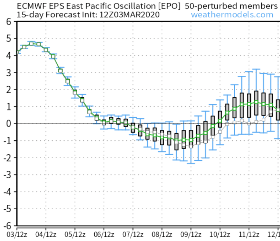
Note the negative dip in the EPO next week. This is what initially grabbed our attention last week (when at that time, looking out 2+ weeks away). Modeling has produced a variety of solutions for the middle of next week for quite some time now (the consistency has been impressive), but the details will vary, and continue to do so for the next several days.
The latest GFS is bullish on the wintry threat (especially for the northern Ohio Valley), but as mentioned above, don’t get wrapped up in the details pertaining to the specifics just yet…

It should be noted, there’s ensemble support as well for the threat of a late season winter event for at least portions of the northern Ohio Valley into the Northeast.
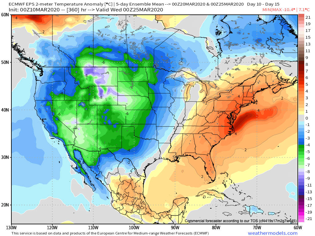
Longer range, it’ll be interesting to see if the NAO and EPO begin to trend negative. Even if the MJO doesn’t want to “play,” those 2 ingredients in tandem can create late season headaches. We note some of our long range, sub-seasonal data is trending towards a look for a colder April.
Interesting times ahead- as always.
Permanent link to this article: https://indywx.com/2020/03/03/at-the-very-least-on-the-playing-field/
Mar 03
Tuesday Morning Rambles And Looking Back At The 2019-2020 Meteorological Winter…
You must be logged in to view this content. Click Here to become a member of IndyWX.com for full access. Already a member of IndyWx.com All-Access? Log-in here.
Permanent link to this article: https://indywx.com/2020/03/03/tuesday-morning-rambles-and-looking-back-at-the-2019-2020-meteorological-winter/
IndyWx.com 7-Day Outlook: Central Indiana

Central Indiana Radar
