
You must be logged in to view this content. Click Here to become a member of IndyWX.com for full access. Already a member of IndyWx.com All-Access? Log-in here.
Permanent link to this article: https://indywx.com/2020/07/24/long-range-update-initial-august-forecast/
Jul 23
VIDEO: Drier Air Arrives For The Weekend; Targeting (2) Cold Fronts Next Week…
You must be logged in to view this content. Click Here to become a member of IndyWX.com for full access. Already a member of IndyWx.com All-Access? Log-in here.
Permanent link to this article: https://indywx.com/2020/07/23/video-drier-air-arrives-for-the-weekend-targeting-2-cold-fronts-next-week/
Jul 22
VIDEO: Unsettled Weather Continues Today Before Drier Air Arrives Into The 1st Half Of The Weekend; Busy Open To August On Deck…
You must be logged in to view this content. Click Here to become a member of IndyWX.com for full access. Already a member of IndyWx.com All-Access? Log-in here.
Permanent link to this article: https://indywx.com/2020/07/22/video-unsettled-weather-continues-today-before-drier-air-arrives-into-the-1st-half-of-the-weekend-busy-open-to-august-on-deck/
Jul 21
Another Round Of Storms Inbound Tonight (Some Strong); Tropics Heat Up; Active Pattern To Close July-Open August…
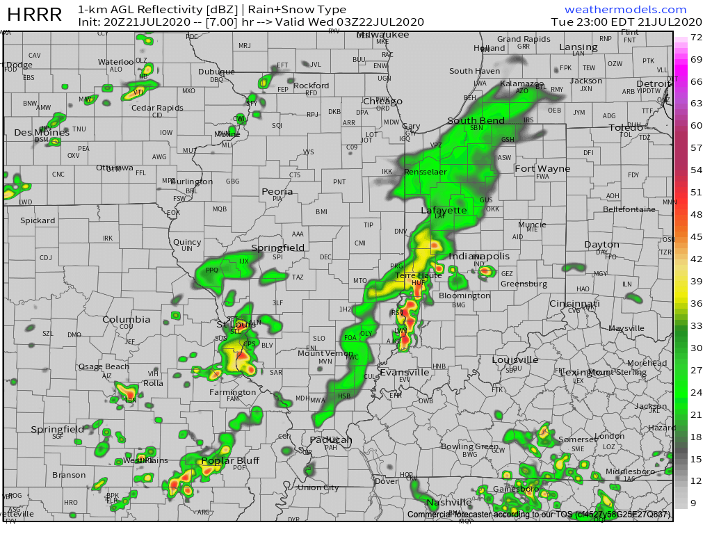
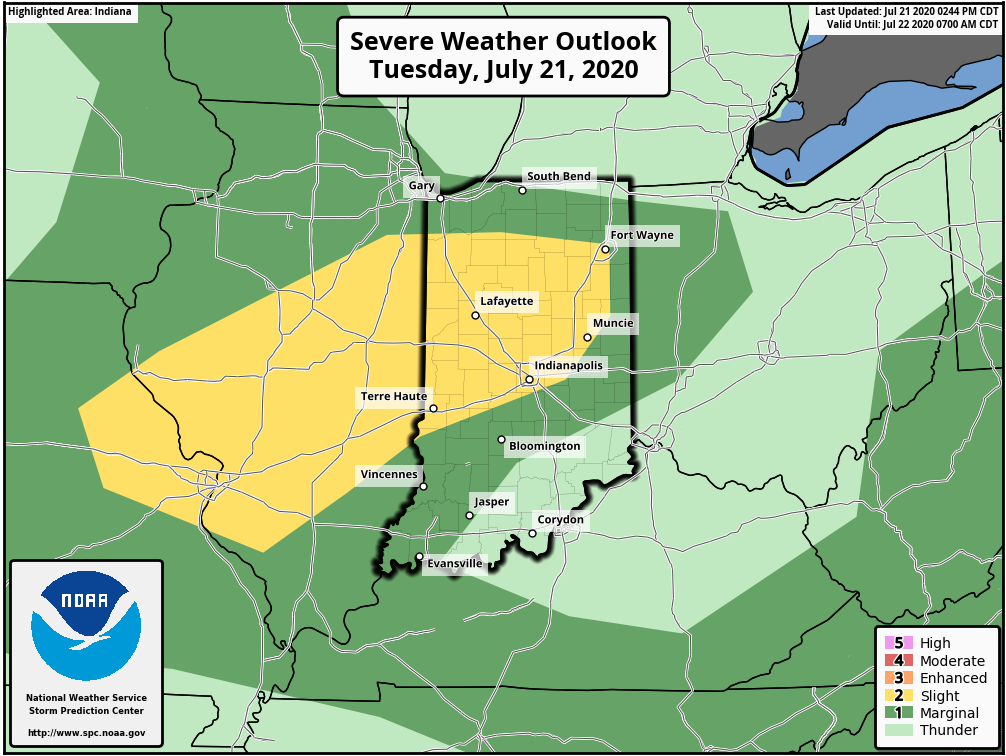
I. A round of strong (and locally severe) storms blew through north-central parts of the state earlier this afternoon and as we write this, yet another batch of storms is erupting across IL. These storms should hold together into central IN late evening (targeting a 8p-11p arrival west to east) and a few could become severe. Ingredients in place favor strong, damaging wind gusts with the stronger cells, but there’s also the opportunity for a quick spin-up tornado. Torrential downpours can be expected with any and all storms. It’ll be wise to keep tabs on the local radar this evening.
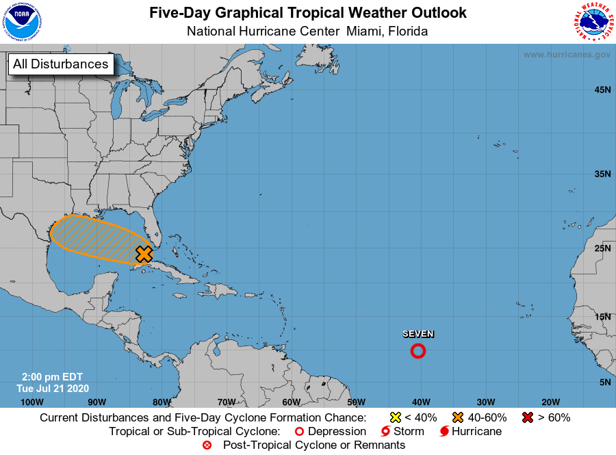
II. As can be expected the deeper into summer we go, the tropics become more active. That’s certainly been the case over the past couple days and all indications continue to point towards a particularly “robust” season as late summer gives way to fall. Interests to the Gulf Coast beaches and Carolina coast should pay close attention to the tropical outlooks in the coming weeks and months. Unfortunately, conditions seem ripe for the opportunity of a few major hurricanes this season, especially when you combine the SST profile with the tendency for the MJO to spend time in Phases 2-3.

In the shorter term, the National Hurricane Center (NHC) is keeping close tabs on the Gulf as well as newly formed TD 7.
III. Overall upper pattern strongly suggests we can expect a very active close to July and open to August. Between next week and the first few days of August, we’re tracking 3 cold fronts that will help to beat back the heat and serve up above normal rainfall through the period (not to mention threat of additional strong to severe storms).
Permanent link to this article: https://indywx.com/2020/07/21/another-round-of-storms-inbound-tonight-some-strong-tropics-heat-up-active-pattern-to-close-july-open-august/
Jul 21
VIDEO: Storm Chances Ramp Up Today; Timing Out Cold Fronts Between Now And Early August…
You must be logged in to view this content. Click Here to become a member of IndyWX.com for full access. Already a member of IndyWx.com All-Access? Log-in here.
Permanent link to this article: https://indywx.com/2020/07/21/video-storm-chances-ramp-up-today-timing-out-cold-fronts-between-now-and-early-august/
Jul 20
VIDEO: Timing Out Storms This Week And Eyes On The August Horizon…
You must be logged in to view this content. Click Here to become a member of IndyWX.com for full access. Already a member of IndyWx.com All-Access? Log-in here.
Permanent link to this article: https://indywx.com/2020/07/20/video-timing-out-storms-this-week-and-eyes-on-the-august-horizon/
Jul 19
More Thoughts On August…
The last month of meteorological summer is on our doorstep and while we’re still several days from having our finalized forecast built, here are some early ideas on where the pattern is going for August. First, let’s start with some modeling:
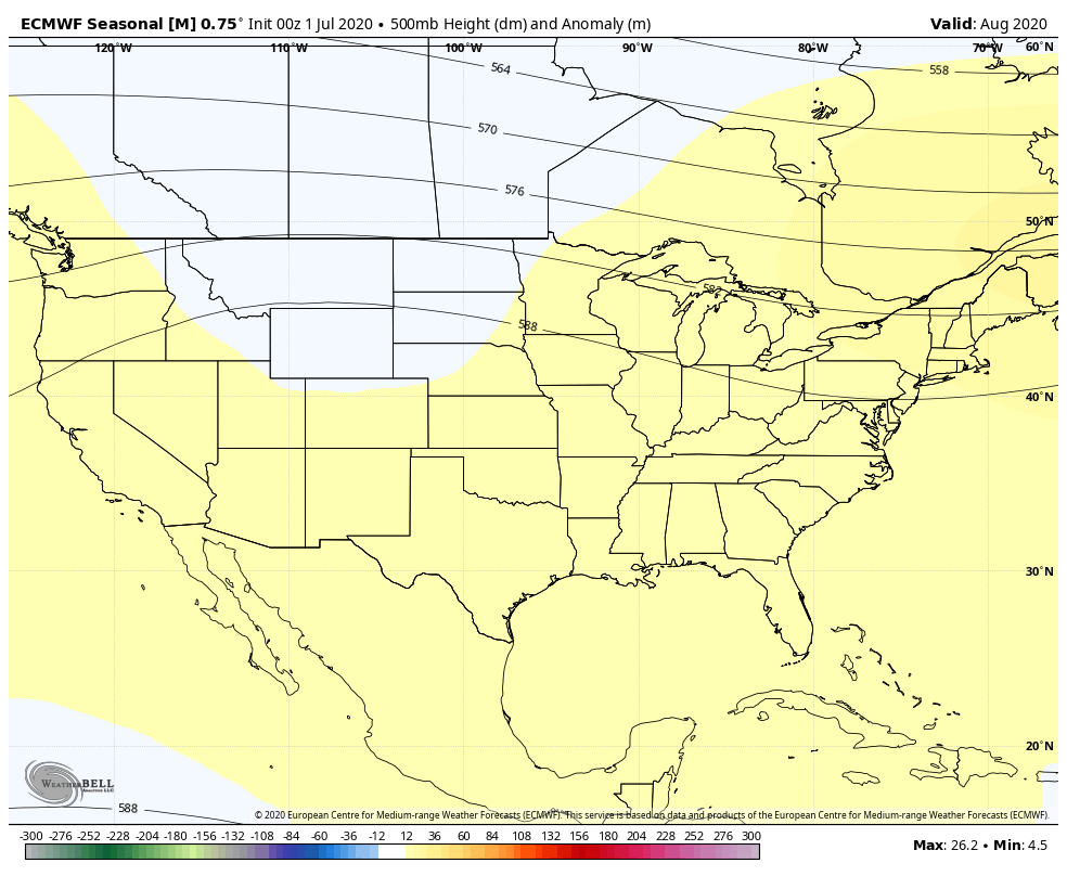
European
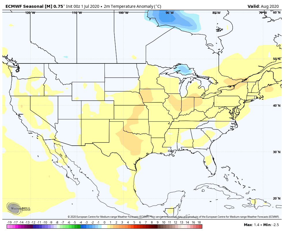
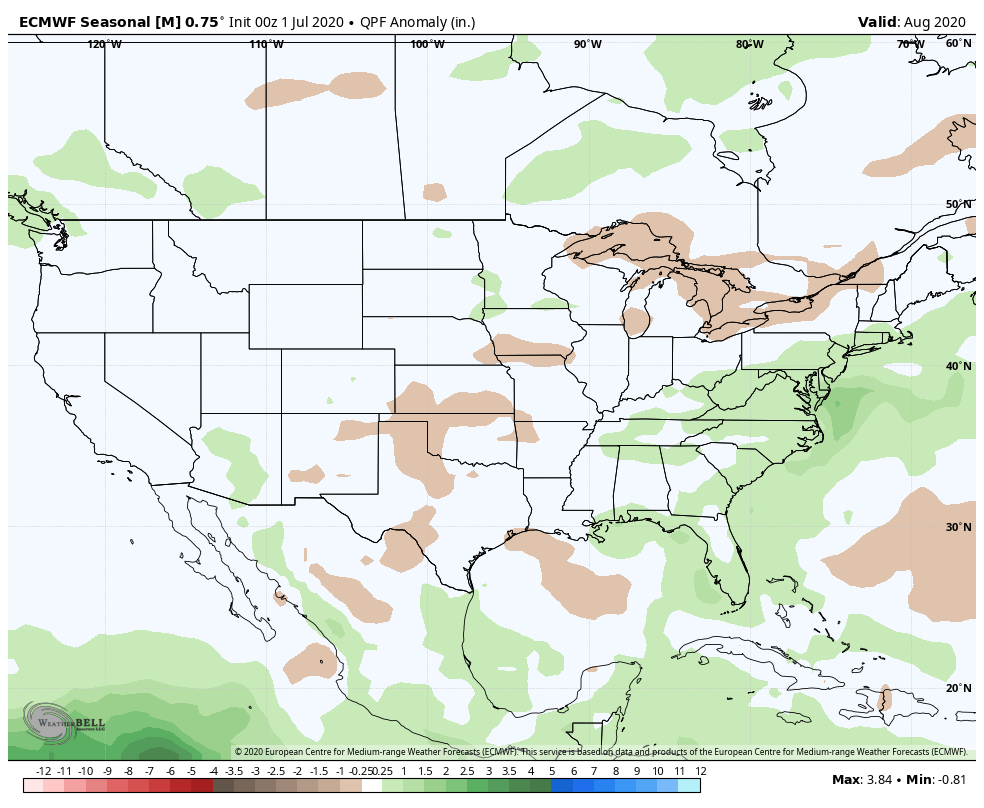
The Euro features the ‘mean’ ridge axis across the inner-mountain West with a northwesterly flow aloft into the Ohio Valley and eastern Lakes. Given the 500mb pattern, one would think the model would have the heat and wet areas shifted west to better correlate with the ridge placement, but that’s not the case. One item of note is that the model may be seeing tropical influences with the wet area across the Southeast and Mid Atlantic.
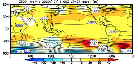
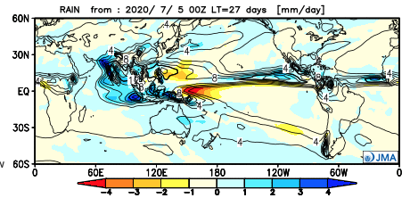
JMA
The JMA is similar with the handling of the 500mb pattern, but better aligns the temperature and precipitation pattern with this look at the upper levels. Brunt of the heat (relative to normal) is across the West with a wet Southeast and Ohio Valley.

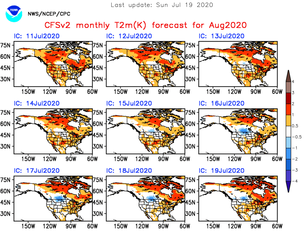
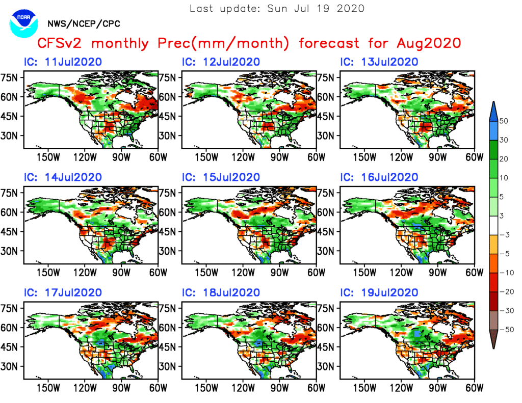
CFSv2
While a bit chaotic with the precipitation idea, the CFSv2 seems to be locking the warmer anomalies into the Central and East for August.
As has been the case, the MJO will likely have a big say in the August pattern (and continuing into the fall and winter). Despite modeled attempts in the past to swing things into Phases 4-7, we’ve been stuck in the 8,1,2, and 3 cycles over the past several months, and in Phases 1-2 over the past 40 days.

The EPO and PNA are in warm phases and this looks to continue overall into early August.
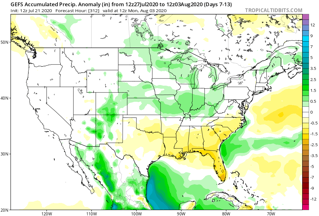
The early lean with our August forecast will feature a large area of above normal temperatures, including across the Ohio Valley (slightly so), along with near average precipitation. We’ll continue to look through the data and present our official August Outlook week after next.
Permanent link to this article: https://indywx.com/2020/07/19/more-thoughts-on-august/
Jul 19
VIDEO: Strong Storms Later This Afternoon-Evening; Timing Out Rain Chances Through The Week Ahead…
You must be logged in to view this content. Click Here to become a member of IndyWX.com for full access. Already a member of IndyWx.com All-Access? Log-in here.
Permanent link to this article: https://indywx.com/2020/07/19/video-strong-storms-later-this-afternoon-evening-timing-out-rain-chances-through-the-week-ahead/
Jul 18
Weekly #AGwx And #Severe Weather Outlook…
I. New heat wave gets underway.
II. Keeping eyes to the sky for periods of gusty storms.
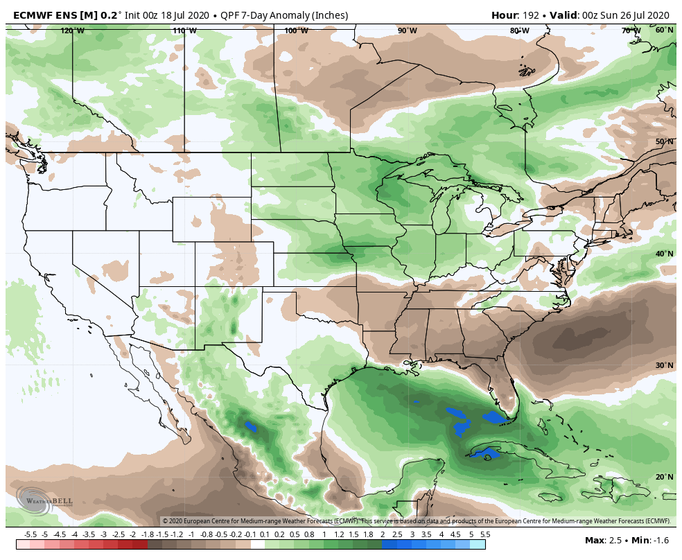
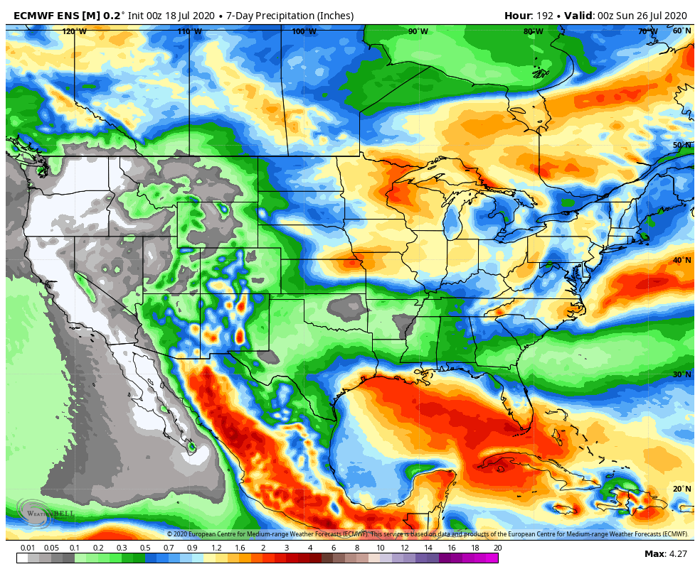
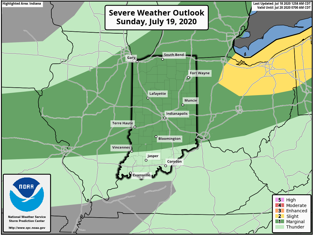
Forecast Period: 07.18.20 through 07.25.20
A hot and humid stretch of weather will dominate the upcoming forecast period, including another multi-day stretch with highs in the lower 90s and lows in the lower 70s. The saving grace? Timely rains. After a mostly dry Saturday (only isolated storm coverage expected), more widespread storms are expected Sunday. Some of these could become strong to severe Sunday afternoon, including the threat of damaging winds as a complex moves south through the state. This unsettled theme will continue into the 1st half of the work week with each day offering up scattered showers and storms. Drier air will briefly nudge into the Ohio Valley Thursday and Friday before storm chances return next weekend.
Permanent link to this article: https://indywx.com/2020/07/18/weekly-agwx-and-severe-weather-outlook-14/
Jul 17
VIDEO: Weekend Outlook; Better Rain Chances Return Early Next Week…
You must be logged in to view this content. Click Here to become a member of IndyWX.com for full access. Already a member of IndyWx.com All-Access? Log-in here.
Permanent link to this article: https://indywx.com/2020/07/17/video-weekend-outlook-better-rain-chances-return-early-next-week/
IndyWx.com 7-Day Outlook: Central Indiana

Central Indiana Radar
