
You must be logged in to view this content. Click Here to become a member of IndyWX.com for full access. Already a member of IndyWx.com All-Access? Log-in here.
Permanent link to this article: https://indywx.com/2020/10/07/video-tracking-delta-pattern-turns-chilly-again-down-the-road/
Oct 06
What Can We Learn From A Persistent Negative October AO For The Upcoming Winter?
October has opened on quite a chilly note across not only central Indiana, but a good chunk of the eastern half of the country. Officially, Indianapolis is running 8.4° below average, month-to-date.

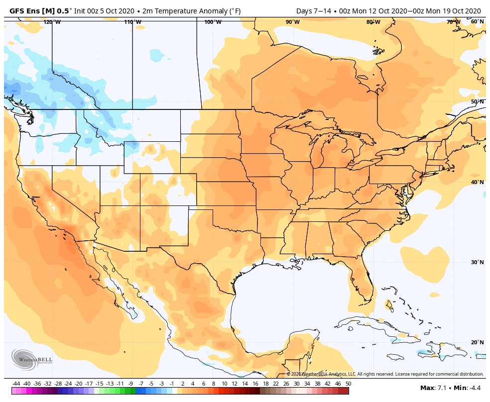
While warming will occur in the upcoming 7-day period, there are already seeds being planted for the return of unseasonably chilly conditions after this transitional warmth.
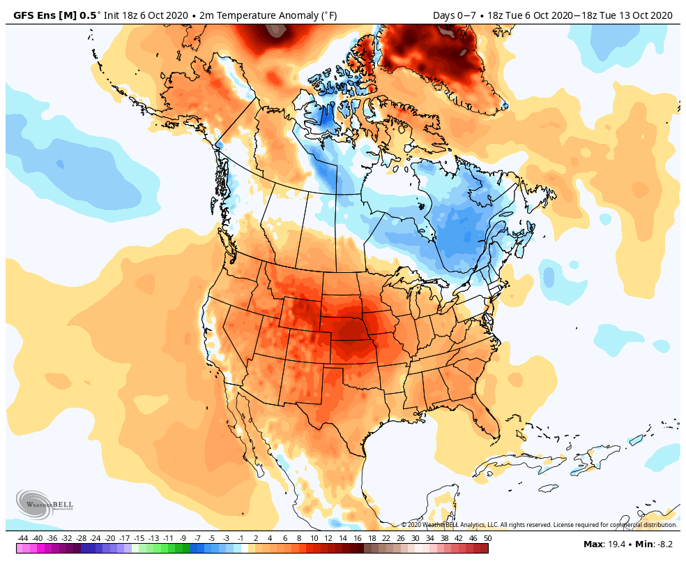
The pattern will take on signs that you’d expect from a positive PNA and trending negative EPO. That will pull the chill back into the east and we may just may trend wetter during the mid and late month period, as a series of cold fronts sweep through the region (fingers crossed).

The purpose of this post is to focus on the predominantly negative Arctic Oscillation (or AO) and what, if anything, we can learn for the upcoming winter. Note the AO continues a negative look over the upcoming couple weeks (it’s been negative so far this month, as well).

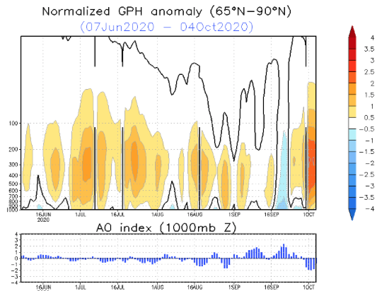
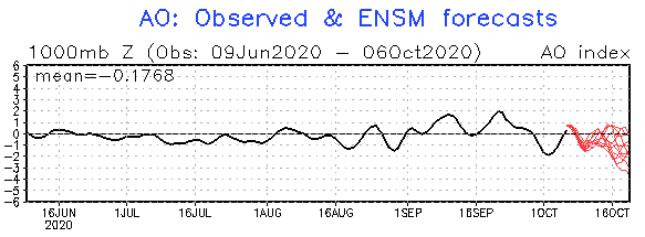
The combination of the persistent negative AO so far this month, along with what’s forecasted over the coming few weeks, got us interested to see what kind of patterns occurred during the following winter (Dec. through Feb.). We went back and looked at all October with a negative AO of 1, or more, since 1960 and this is what the analogs produced:
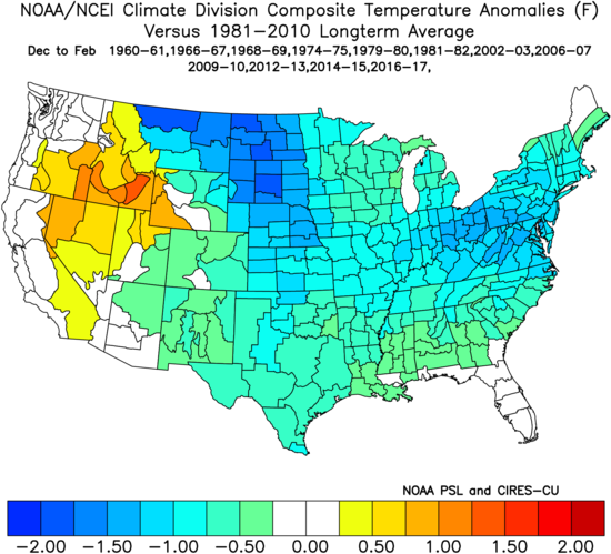

There’s obviously a lot of other ingredients we’ll factor into our winter outlook this year (per usual), but this is another interesting case study in front of us, especially with so many climate models blow torching the upcoming winter.
Our complete annual winter outlook will be online Sunday, November 1st.
Permanent link to this article: https://indywx.com/2020/10/06/what-can-we-learn-from-a-persistent-negative-october-ao-for-the-upcoming-winter/
Oct 06
VIDEO: Delta Will Become A Major Hurricane Today; More On This And Reasons Why Our Mid-October Trough Should Trend Stronger…
You must be logged in to view this content. Click Here to become a member of IndyWX.com for full access. Already a member of IndyWx.com All-Access? Log-in here.
Permanent link to this article: https://indywx.com/2020/10/06/video-delta-will-become-a-major-hurricane-today-more-on-this-and-reasons-why-our-mid-october-trough-should-trend-stronger/
Oct 05
Soon-To-Be “Delta” Makes For A Busy Week Along The Gulf Coast; 3-Week Outlook For Central IN…
Before we talk tropics, frost is widespread this morning across the state. We note some are even at the freezing mark as we start the new work week.
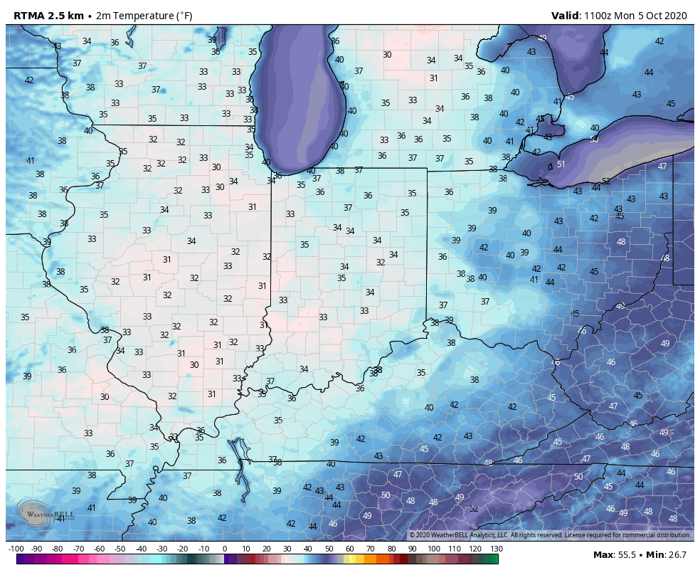
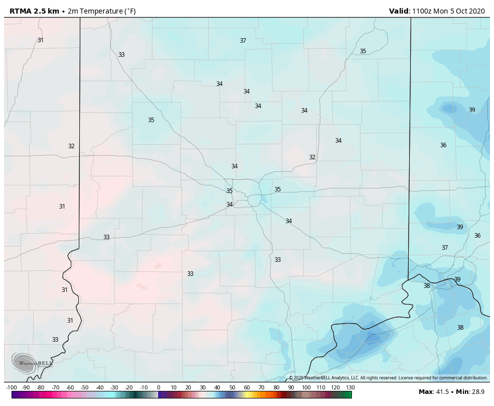
This is right around average, or just a few days early, for our first 32° freeze of the year across central Indiana.

Expect bright sunshine and another classic fall sky this afternoon which will help warm us to around 60°.
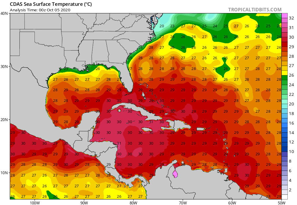
The week ahead will feature quiet conditions across the region. We’ll watch a couple of cold fronts scoot by to our northeast and, of course, soon-to-be Delta in the Gulf of Mexico. Delta will likely strengthen into a hurricane before reaching the north-central Gulf Coast late week. There are ingredients in place that may result in rapid intensification later this week and the potential of Delta strengthening into a major hurricane is on the table, IMHO. Thankfully, the combination of increasing wind shear and cooler sea surface temperatures right along the coast (thanks to the early fall fronts that have made it unusually far south) should help lead to weakening prior to landfall. The problem with that, however, is if the system is coming in as a major, storm surge will still be quite significant.


If you have plans to travel to the northern Gulf Coast, please pay particularly close attention to the develops over the coming hours and days. As of this morning, it appears as if we’ll be looking at a Friday landfall.
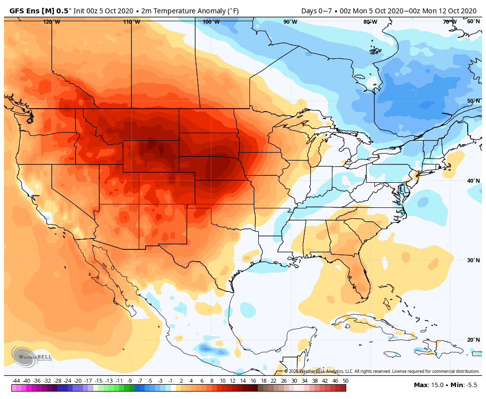
Back here on the home front, quiet conditions are expected this week- and for the most part over the next few weeks. Perhaps the next item of excitement will be a cold front pegged to move through the region in the 8-10 day period. We’ll need to keep close eyes on the EPO/ PNA trends in the Week 2 period for the possibility of a sharp jab of colder air behind that cold front. This would come after a nice surge of warmth (Indian Summer) compared to normal. Additionally, looking even further ahead, longer range guidance is beginning to get excited around the potential of unseasonably cold (wintry like) air to open November.
Week 1
Week 2
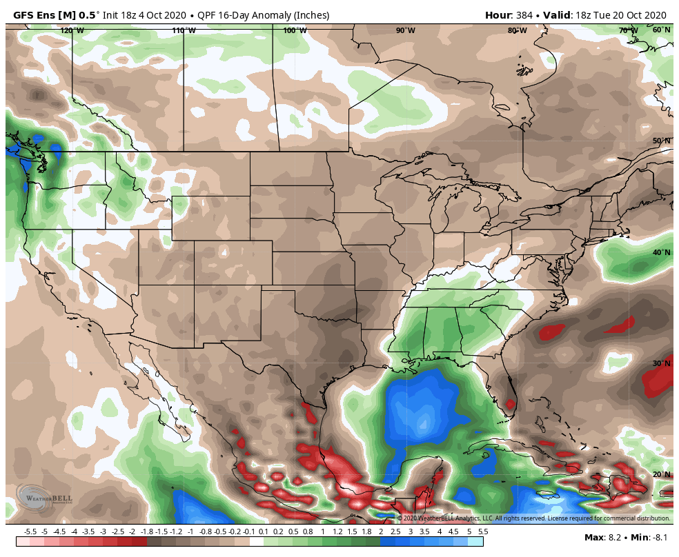
As expected, the pattern should continue to run quite dry through the better part of the period:
Permanent link to this article: https://indywx.com/2020/10/05/soon-to-be-delta-makes-for-a-busy-week-along-the-gulf-coast-3-week-outlook-for-central-in/
Oct 04
VIDEO: Frosty Start Monday Gives Way To Moderating Temperatures This Week; Keeping Close Eyes On The Gulf…
You must be logged in to view this content. Click Here to become a member of IndyWX.com for full access. Already a member of IndyWx.com All-Access? Log-in here.
Permanent link to this article: https://indywx.com/2020/10/04/video-frosty-start-monday-gives-way-to-moderating-temperatures-this-week-keeping-close-eyes-on-the-gulf/
Oct 03
VIDEO: Looking Ahead Over The Next Couple Weeks…
You must be logged in to view this content. Click Here to become a member of IndyWX.com for full access. Already a member of IndyWx.com All-Access? Log-in here.
Permanent link to this article: https://indywx.com/2020/10/03/video-looking-ahead-over-the-next-couple-weeks/
Oct 02
VIDEO: Frosty Start Ahead Saturday For Some; Looking Ahead To Next Week…
You must be logged in to view this content. Click Here to become a member of IndyWX.com for full access. Already a member of IndyWx.com All-Access? Log-in here.
Permanent link to this article: https://indywx.com/2020/10/02/video-frosty-start-ahead-saturday-for-some-looking-ahead-to-next-week/
Oct 01
October 2020 Outlook…
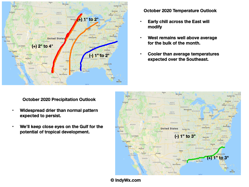
Average temperatures for the month of October fall from 71° and 50° on the 1st to 60° and 41° by Halloween. Indianapolis averages 3.12″ of rain this month and 0.40″ of snow.
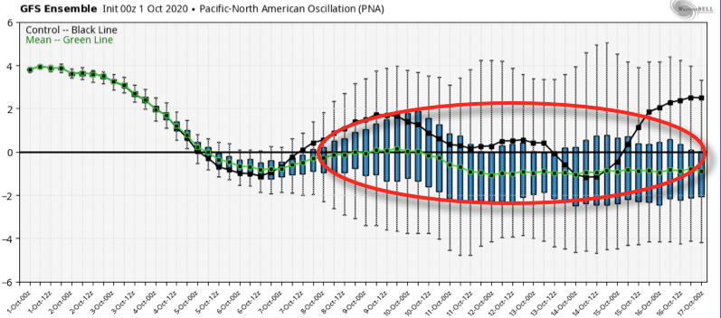
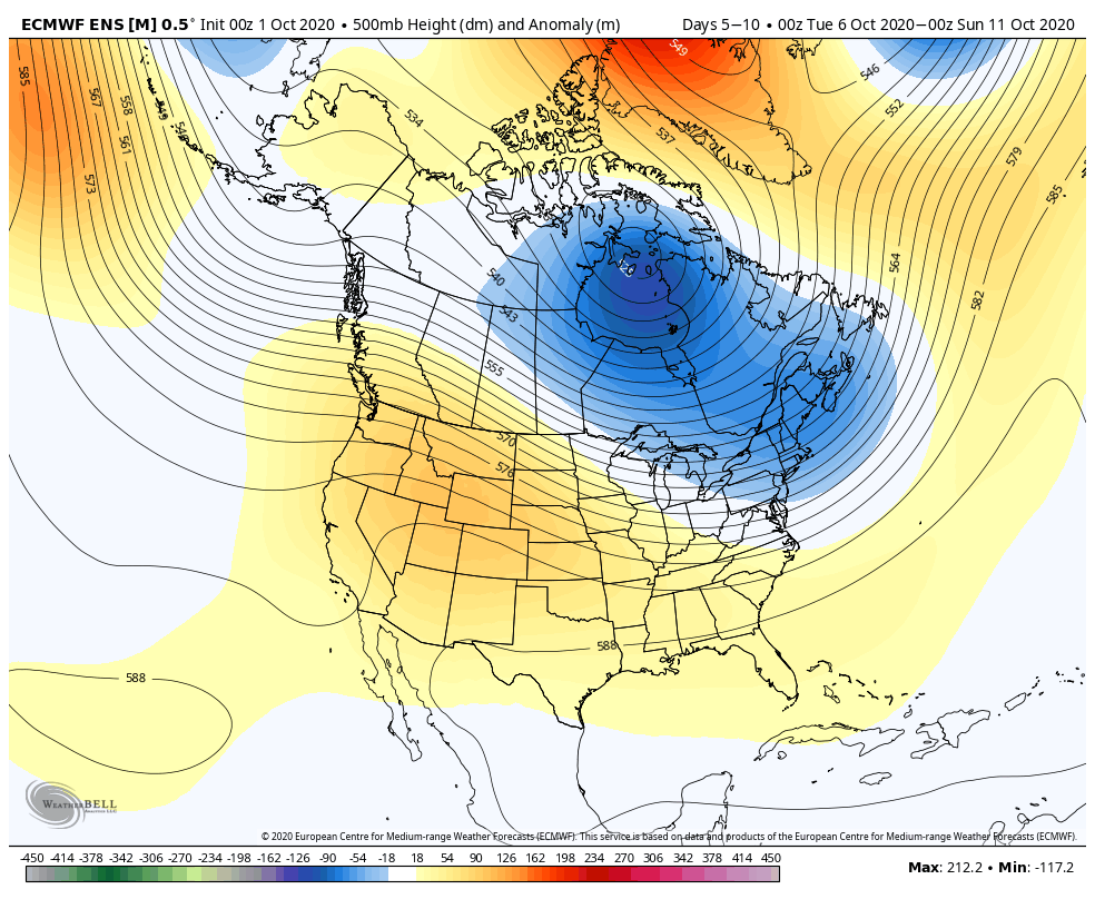
We expect the MJO to remain in Phase 5 for the better part of the first half of the month. This, in conjunction with the positive PNA and negative EPO, will help drive the early cool pattern into the East. Note how that begins to change next week (the PNA goes negative and the EPO goes positive). This will likely erode a lot of the cool air and slowly, but surely allow warmer temperatures to penetrate east into the Ohio Valley beyond the 10th (give or take a day).

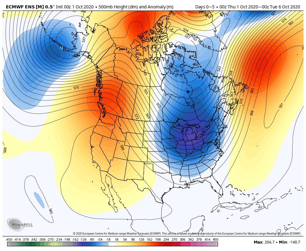
Note how the upper pattern follows suit:
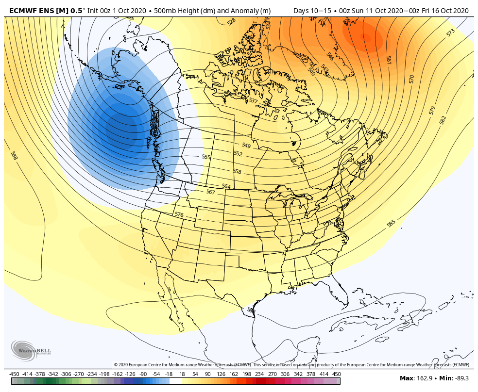
The end result should be an unusually chilly start to the month that moderates towards mid and late month. Based on the MJO movement, there’s the potential of chill making a comeback just before Halloween (and into November), but this is a lower confidence call at this point. We’ll keep an eye on that as we move through the next few weeks. From a precipitation perspective, another very dry month is ahead. We’ll end up wetter than September, but still several weeks away from truly changing the precipitation pattern up from a holistic standpoint.
Here’s our official October Outlook. For central Indiana in particular, we expect an average to slightly above average temperature month (less than 1° above average) with well below normal rainfall.
Permanent link to this article: https://indywx.com/2020/10/01/october-2020-outlook/
Sep 30
VIDEO: Today’s Gusty Winds Offer Up Chilly Reinforcements Heading Into The Weekend…
You must be logged in to view this content. Click Here to become a member of IndyWX.com for full access. Already a member of IndyWx.com All-Access? Log-in here.
Permanent link to this article: https://indywx.com/2020/09/30/video-todays-gusty-winds-offer-up-chilly-reinforcements-heading-into-the-weekend/
Sep 29
VIDEO: Unseasonably Chilly First 1/3 Of October, But Then What?
You must be logged in to view this content. Click Here to become a member of IndyWX.com for full access. Already a member of IndyWx.com All-Access? Log-in here.
Permanent link to this article: https://indywx.com/2020/09/29/video-unseasonably-chilly-first-1-3-of-october-but-then-what/
IndyWx.com 7-Day Outlook: Central Indiana

Central Indiana Radar
