Thoughts On Winter…

This is the first time since 2002 that I haven’t produced a winter outlook.  Part of the reason behind this is due to the fact that our recent move back from Cleveland, OH to Indianapolis has taken priority.  Moving is always a much bigger chore than you expect originally.  That said, the upcoming winter of 2013-2014 presents quite the challenge when trying to determine what particular player takes control for the “long haul.”  I can’t remember a time when so many variables were at play, presenting quite the headache in trying to determine which one will take the lead.  Ultimately, confidence is lower than normal for the winter forecast.  That said, “confidence” in something 3-4 months out is never considered high. 🙂

Here are just a few items I’m looking at for the upcoming winter:

1. Data is pointing towards a southeast ridge in play for the better part of the upcoming winter.

The strength and precise position of the ridge will go a long way in aiding our weather here in central Indiana.  Southeast ridging isn’t always a bad thing in the winter if you’re a cold and snow fan as storms can’t “escape” harmlessly to our south or east.  That said, should we deal with a strong southeast ridge then we’re looking at a warmer, rainier time of things here as opposed to cold and snowy…

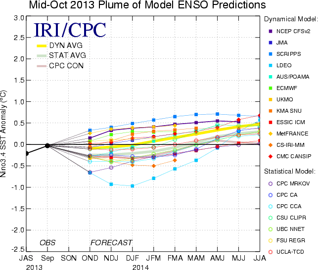
2. Modeling suggesting Nino Region 3.4 warms slightly as we progress through the winter months.
SST_table


The implications here are interesting when we drill down to the “home front.”  The following data from similar conditions during December-February in Nino Region 3.4 correlate to a few years that will go down in Hoosier snow lovers dreams…

Courtesy: http://www.cpc.ncep.noaa.gov/products/analysis_monitoring/ensostuff/ensoyears.shtml
  • 1977-1978: 49.7″ of snow, 2nd snowiest winter on record; Nino Region 3.4: +0.8
  • 2002-2003: 46.9″ of snow, 4th snowiest winter on record; Nino Region 3.4: +1.2
  • 2009-2010: 32.2″ of snow, 10th snowiest winter on record; Nino Region 3.4: +1.6

3. NAO showing signs of going negative when it matters most?

Labeled as the new “NAO Model everyone is looking for” may, perhaps, be just that.  This formula has already proven to be incredibly accurate in the past.  This was developed by fellow midwestern, Al Marinaro (you can follow him on Twitter at @wxmidwest).  In the past I’ve been one to say it’s incredibly difficult to forecast the NAO beyond 2-3 weeks, but we look at water temperatures this time of year to try and get an idea of what may happen in the coming winter months ahead.  If Mr. Marinaro is on to something (and it appears that he is) that longstanding idea will all change.

Additionally, to the delight of many cold and snow lovers out there, Mr. Marinaro’s formula suggests we’re heading for a predominantly negative NAO this winter.

BXihwRqCIAAtd3d.png-large


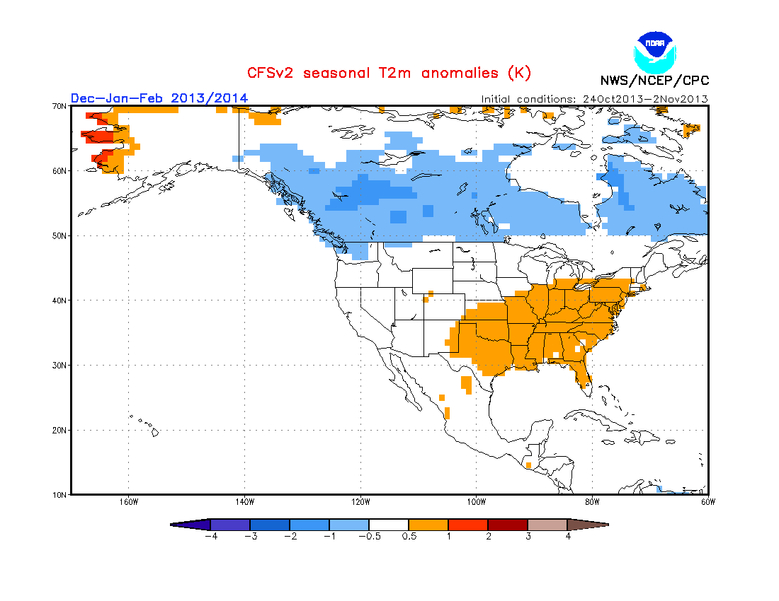
4. The normally “highly variable” CFSv2 (Climate Forecast System) monthly run has remained consistent as of late in thinking the east is warmer than normal for meteorological winter.  

It’s amazing how often this model is shown when forecasting cold, but seemingly forgotten when it’s forecasting warmer than normal conditions.
usT2mSeaInd2


Monday Forecast: Tracking Another Storm

Updated 11.03.13 @ 3:30p

Zionsville, IN It’s been a beautiful fall weekend across central Indiana. Aside from a couple of quick-moving showers Saturday evening, the weather couldn’t have been more perfect!  While the work week will start off on a pleasant note, we’re tracking another storm and significant blast of chill later this week.

Status-weather-clouds-iconMonday: Partly to mostly cloudy; 38/ 58

The day should dawn with bright sunshine, however, we note the latest high resolution short-term model data suggesting mid and high level cloudiness will be on the increase through the afternoon hours.  It’ll be a dry day with seasonable temperatures.  Enjoy!

Status-weather-showers-day-iconTuesday: Mostly cloudy; nighttime light showers (0.10″); 44/ 61

We’ll be in between high pressure to our east and our next approaching storm system to our west. As a result, a return southerly flow of air will help begin to transport milder air northward, along with increasing moisture Tuesday evening. The daytime hours should remain rain-free, but we’ll introduce a couple of light showers into our forecast Tuesday night.

Status-weather-storm-night-iconWednesday: Showers and thunderstorms, especially at night (0.70″); 49/ 60

A significant cold front will approach the region Wednesday. Showers will be likely through the day, but we still believe the heavier rains and embedded thunder will hold off until Wednesday night (especially after dark).  While we’re still monitoring any threat of severe weather, the bigger threat at this time appears to be another round of heavy rain falling atop a waterlogged central Indiana.  Stay tuned as we continue to analyze the latest data and update things accordingly.

Status-weather-showers-day-iconThursday: AM showers and thunderstorms (0.40″);  38/ 55 (falling)

The cold front will blow through the region Thursday morning.  Showers and thunderstorms will end west to east during the morning followed by a sharp temperature decline through the day, coupled with strong northwesterly winds gusting upwards of 30 MPH.

Status-weather-clouds-iconFriday: Partly cloudy; 29/ 48

A much colder air mass will settle into central Indiana Thursday evening and result in a hard freeze Friday morning. After waking up to lows in the upper 20s, highs will reach the upper 40s with partly cloudy skies.


Status-weather-clouds-iconSaturday: Partly cloudy and breezy; 40/ 55

Our fast-moving weather pattern will remain next weekend.  We’re tracking another storm system that will blow through the Great Lakes region Saturday. Current thinking places the track of this low too far north to impact the region from a precipitation standpoint, but we’ll certainly note a strengthening southwesterly wind Saturday followed by another shot of cold air Saturday night/ Sunday.  Highs next Sunday will likely remain in the 40s…


Saturday Forecast: Chilly Weekend; Eyeing Another Significant Storm…

Updated 11.01.13 @ 10:53p Zionsville, IN After a day filled with heavy rain and damaging winds, we closed the week out with chilly, but pleasant weather conditions.  We’ll enjoy a…

You must be logged in to view this content. Click Here to become a member of IndyWX.com for full access.  Already a member of IndyWx.com All-Access?  Log-in here.

Tuesday Forecast: Changes Brewing…

Updated 10.29.13 @ 9:37a

Zionsville, IN It’s another calm, cold, quiet start to the day, but changes are brewing. These changes include warmer, more muggy air by tonight and Wednesday, widespread rain and storms for mid week, and another temperature plunge for the weekend.

Status-weather-showers-day-iconTuesday: Mostly cloudy; scattered nighttime showers; 0.10″; 37/ 62

After a calm, cold start to the day, clouds will increase and showers will develop tonight. We currently note widespread rain and embedded thunder across MO, but this will weaken as it encounters our dry air mass tonight. Light rain will likely overspread the region from southwest to northeast as we move through the nighttime hours.

Status-weather-showers-day-iconWednesday: Scattered showers; 0.10″; 55/ 67

The big story on Wednesday won’t be the rain, but instead the briefly warmer surge of air out ahead of our cold front. In fact, most of Wednesday should remain rain-free. Latest high resolution short term model data points to showers and a rumble of thunder exiting stage right Wednesday morning and while we can’t rule out an additional shower or thundershower through the day, most of the time will be rain-free Wednesday. South winds will begin to increase during the afternoon, gusting over 20 MPH.

Status-weather-storm-night-iconHalloween: Showers and thunderstorms; 1.10″; 59/ 66

A strong cold front will plow into the state Thursday night. Out ahead of this boundary, abundant moisture will surge north into the area. We’re not looking at all day rains Thursday, but target the afternoon-nighttime hours when rain and thunderstorms will be the most widespread. Additionally, we continue to monitor the severe threat with this system. Widespread and significant severe thunderstorms will be likely across southern IN and points south to include the western TN Valley. That said, severe weather reports will likely extend north to include central Indiana, as well. As of now, the primary severe threat appears to be from a damaging straight line wind perspective across our neck of the woods. Heavy rainfall will also be common as widespread 1″+ rains are likely.  Needless to say, you’ll certainly want to keep those weather radios tuned in Thursday.

Status-weather-clouds-iconFriday: Partly cloudy and breezy; 45/ 59 

The cold front will be to our east Friday, allowing the sunshine to return. It’ll be a breezy day, but the true cold air advection will hold off until Saturday, so temperatures will be very near seasonal levels Friday with a gusty northwest breeze.

imagesSaturday: Mostly cloudy; PM scattered showers (wet snow flake mixed in); 0.05″; 37/ 47

Fresh cold air will pour into the state Saturday and be accompanied by some upper level energy to create the threat of afternoon scattered showers.  Precipitation may mix with a wet snow flake Saturday evening. We think the day shapes up as a cold, raw day that will certainly require that jackets and sweaters.

Status-weather-clouds-iconSunday: Partly cloudy; 32/ 55

We’ll wrap up the weekend with sunshine returning.  Temperatures will begin to moderate closer to where we should be for this time of year, after a cold and frosty start.


Status-weather-clouds-iconMonday: Partly cloudy; 37/ 63

As high pressure moves to our east, it’ll allow a warmer return flow out of the southwest to help take over the region for the start of another work week. We’ll monitor a storm system to our west, but forecast dry skies for now next Monday.

Monday Forecast: Halloween Storm In The Works

Updated 10.28.13 @ 9:01a

Zionsville, IN We’re opening the work week with cold and frosty conditions, but changes are brewing that will provide significant rain, strong winds, and thunderstorms by Halloween.  The details are below!

Status-weather-clear-iconMonday: Mostly sunny; 29/ 59

We remain under the influence of high pressure today and this will supply the region with plenty of vitamin D before “cloudier, stormier” times await later this week.  After a frosty start to the day, temperatures will moderate very near the 60 degree mark!


Status-weather-showers-day-iconTuesday: Increasing clouds; Nighttime showers; 0.25″; 37/ 58

A warm front will lift through central Indiana Tuesday afternoon. As the warmer, more moist air runs over the top of the chilly, drier air at the surface clouds will develop and we think scattered showers and perhaps a rumble of thunder begin to roll into the state Tuesday evening/ night.

Status-weather-showers-day-iconWednesday: Scattered showers; 0.25″; 52/ 67

We’ll remain in an unsettled weather pattern for the middle of the week. While most of Wednesday looks dry as of now, we can’t rule out a scattered shower or thunderstorm. Wednesday will be a warmer and windy day as south winds blow ahead of our approaching cold front. In fact, temperatures will approach the 70 degree mark for many Wednesday.

Status-weather-storm-night-iconHalloween: Showers and thunderstorms; 1.25″; 55/ 65

Showers and thunderstorms will become widespread on your Halloween, particularly Thursday evening and night. Some stronger storms are possible with a severe report or two not out of the question.  As of now, our thinking is the more widespread severe threat will remain to our south, and include portions of southwestern Kentucky and western Tennessee. Just make a mental note if your travel plans take you south Thursday.

Status-weather-showers-day-iconFriday: Scattered showers; 0.20″; 43/ 59 (falling)

The cold front will push east of the state Friday morning and a cooler air mass will move in for the weekend. We’ll include the mention of left over light showers/ drizzle Friday, but the bigger story will be gusty northwest winds and falling temperatures.

imagesSaturday: Mostly cloudy; Scattered shower (wet snow flake?); 0.05; 36/ 47

A much colder, northwesterly flow will be in control Saturday. This will keep the region much cooler than normal. Some upper level energy will rotate southeast over the region and may be strong enough to generate some scattered showers (potentially mixed with a wet snow flake).

Status-weather-clear-iconSunday: Mostly sunny; 31/ 55

We’ll wrap up the weekend with sunshine returning and cool, crisp fall conditions in place!