Have To Love “Over-Achieving” Clippers…

Good Morning, Hoosiers!  We’re awaking to a snowy commute, as promised, but our little clipper could certainly be called an “over-achiever.” We’re receiving many reports of snowfall amounts of 1.5″…

You must be logged in to view this content. Click Here to become a member of IndyWX.com for full access.  Already a member of IndyWx.com All-Access?  Log-in here.

Arctic Cold, Forecast, snow

Tracking Two Light Snow Producers

Following on the heels of another early winter weather maker, we’re tracking renewed cold blowing into the region and two light snow producers the next couple of days.  The first clipper system will likely deliver some light snow accumulations (generally 1″, or less) tonight into the wee morning hours Monday.  The latest short-term, high-resolution, model data is picking up on this nicely.  While we’re not looking at significant snowfall, it’ll be just enough to lead to a slick Monday morning commute for some, especially from the city and northern ‘burbs.

Here’s a look at the simulated radar valid for this evening at 10 o’clock.  Light snow is spreading back into central Indiana.

HRRR1

Additionally, we’ll keep an eye on yet another fast-moving clipper Monday night and early Tuesday that will also have the potential of dropping a quick light accumulating snow (again, most likely 1″ or less).  All-in-all, we’re still locking tightly into Old Man Winter’s grip the next few days.

Period Of Heavy Snow Coming

Latest short-term, high resolution, models are showing what’s taking shape nicely this morning. We think the city and points north will undergo a period of moderate to heavy snow from late morning into the early afternoon hours.

Within the highlighted area, we think snowfall rates will approach 1″ per hour between 10a-2p.  Yes, within that (4) hour time period, don’t be surprised if a few reports come in with 3-4 additional inches of snow atop what’s already fallen, particularly across the northern half of the highlighted area.

HVYSnow

Here’s a look at the latest HRRR model simulated radar showing the swath of moderate to heavy snow coming over the next few hours.  Again, high snowfall rates will make plowing duties difficult so if you must travel, please take things slow.

hrrr_ref_ne_8

South-central Indiana will see dramatically less snow due to mixing issues (as forecast) and the dry slot that is arriving now.  The track of the upper low should lock moderate to heavy snow into central and north-central Indiana into the early to mid afternoon.  All of the snow will then begin to diminish and move northeast during the early to mid afternoon, as our storm system departs.  This will then allow northwest winds to strengthen and become gusty this evening, with cold air pouring back into the region.

Friday Night-Saturday Winter Storm

As a whole, we still feel good about our accumulation ideas that we’ve had out a few days now…widespread 4-5″ of snow is a good bet for most of central…

You must be logged in to view this content. Click Here to become a member of IndyWX.com for full access.  Already a member of IndyWx.com All-Access?  Log-in here.

Forecast, snow

Old Man Winter Jabbing Now, But Is The Knock-Out Punch Coming?

Before we discuss what may lie ahead closer to Christmas, our going forecast for Friday night and Saturday’s snow storm hasn’t change…4-5″ for the greater Indianapolis region by late Saturday morning.

Since really back in the middle of October we noted a distinct pattern change that has resulted in a colder than normal regime around these parts ever since.  As we look ahead, there really aren’t any indicators that would suggest we’ll deal with warmer than normal air for any period of significant time through the remainder of the year.  Furthermore, there are multiple computer models hinting that we’ll have to deal with a significant winter storm and potentially a shot of brutal cold as we rumble closer to the busy Christmas week.

It’s very important to note that we still have several days to watch the goings on for Christmas week, but the stage has at least been set for the possibility of a storm of “importance” being around the region as we near that particular time period.

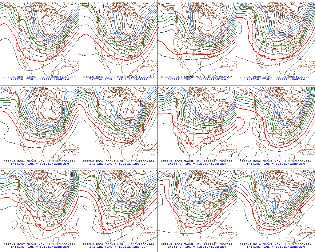
Confidence is growing on brutal cold (most likely record-breaking) initially dumping into the Plains states towards the latter portion of next week.  With time, we think this cold slugs it’s way east.  Before the arctic intrusion gains control of the Mid West and Ohio Valley, we think this is the area that stands the greatest chance of dealing with a major winter storm.  We have strong ensemble support (pictured below) of the evolution of the overall pattern, but we caution that the precise details will have to be ironed out.
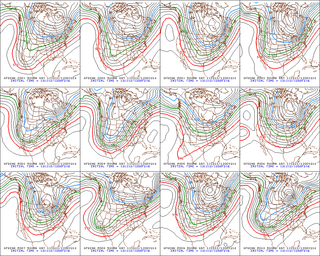
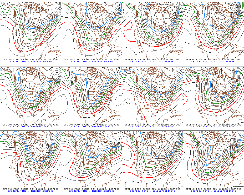
Ensemble1Ensemble2Ensemble3

The “sensible” weather that would ensue here across central Indiana could vary wildly from a significant full-blown winter storm with all of the precipitation falling in the form of a wintry variety (i.e. snow, sleet, freezing rain) to a situation that features a western track with briefly milder air surging north into portions of the region and leading to a rain-to-snow situation.  The accumulation ideas would swing from a significant, plowable, snow storm to as little as a coating with arctic air blowing in behind the rain to snow scenario.

At the end of the day right now we’re confident on two things: 1.) a major winter storm around the Mid West/ Ohio Valley as we near Christmas week and 2.) brutal arctic air swinging into the area around Christmas.  Questions will have to be answered as we move ahead to determine the precise precipitation amounts and type.

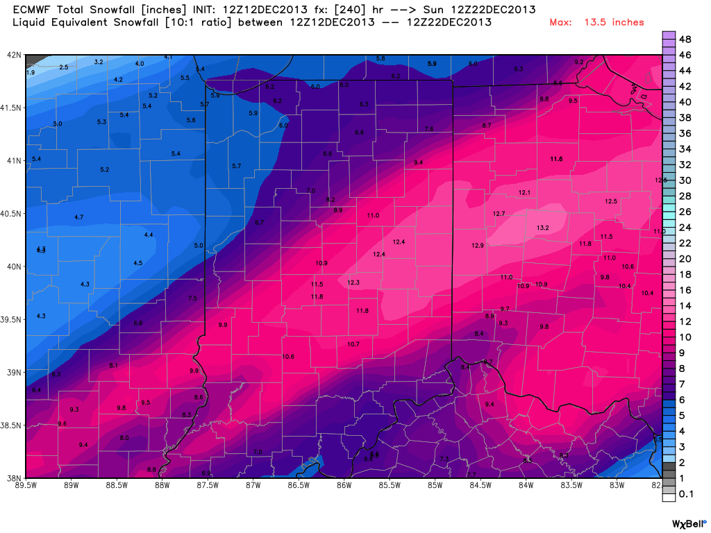
In closing, just for fun, we thought we’d provide a look at the latest European forecast model data.  Here’s a look at the upcoming 10 day European model snowfall forecast.  Of course, these amounts account for the 4-5″ expected here tomorrow night and Saturday,  but (2) additional systems also add to the potential growing snow pack…a clipper system Monday and the “more important” system next weekend.  Stay tuned.
Euro1