It’s an extremely busy morning here and we won’t have time to post the fresh 7-Day forecast until this evening. After a round of thunderstorms overnight, precipitation has now transitioned…
You must be logged in to view this content. Click Here to become a member of IndyWX.com for full access. Already a member of IndyWx.com All-Access? Log-in here.
Permanent link to this article: https://indywx.com/busy-morning-quick-weather-word/
-
Filed under Arctic Cold, Forecast Discussion, Forecast Models, Heavy Rain, Rain, snow, T-storms, Unseasonably Cool Weather, Windy, Winter Storm
-
March 11, 2014
1.) We don’t really have any changes to the going snowfall accumulation forecast we have out concerning Wednesday. We think Indianapolis accumulates 2″, with heavier amounts north of the city…
You must be logged in to view this content. Click Here to become a member of IndyWX.com for full access. Already a member of IndyWx.com All-Access? Log-in here.
Permanent link to this article: https://indywx.com/catching-up-after-a-day-outside-enjoying-this-weather/
URGENT – WINTER WEATHER MESSAGE NATIONAL WEATHER SERVICE INDIANAPOLIS IN 347 PM EDT TUE MAR 11 2014 …WINTER WEATHER TO IMPACT CENTRAL INDIANA… .A LOW PRESSURE SYSTEM MOVING THROUGH THE…
You must be logged in to view this content. Click Here to become a member of IndyWX.com for full access. Already a member of IndyWx.com All-Access? Log-in here.
Permanent link to this article: https://indywx.com/winter-weather-advisory-issued-from-4a-to-4p-wednesday/
Good morning, Indy! While we’ll reach the warmest temperatures of the year, so far, today (lower to middle 60s across central Indiana), we continue to monitor the goings on for accumulating snow on Wednesday.
The latest high resolution data shows rain changing to snow during the morning Wednesday across our area- between 7 and 9 o’clock from north to south:
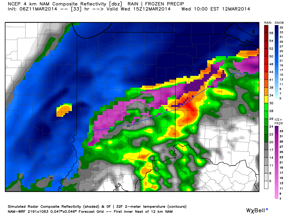
Here are some quick bullet point thoughts and we’ll have a more complete update posted this evening:
- Rain changes to snow between 7-9a from north to south
- Period of heavy snow falls from 10a to 1p
- Gusty northeast winds will approach 40 MPH resulting in blowing and drifting where snow accumulates
- Going accumulation idea remains unchanged for now- 2″ or less for the city and points south; 2-5″ north of the city. Heaviest snowfall will be laid down across northern Indiana where amounts over 8″ are likely.
Permanent link to this article: https://indywx.com/downright-spring-like-today-gives-way-to-a-snowy-wednesday/
-
Filed under Arctic Cold, Canadian Model, European Model, Forecast Discussion, Forecast Models, GFS, Rain, snow, Unseasonably Cool Weather, Unseasonably Warm
-
March 10, 2014
The region has been under the influence of a cold eastern trough month to date with a brief relaxation taking place presently. The frigid March start and anomalously cold east…
You must be logged in to view this content. Click Here to become a member of IndyWX.com for full access. Already a member of IndyWx.com All-Access? Log-in here.
Permanent link to this article: https://indywx.com/a-look-at-where-weve-been-and-where-were-going/

