Carefully Watching Monday Night/ Tuesday For Storm Potential…

While rain and chilly air are the headlines as we wrap up the work week and open another important college football weekend (my anticipation is building rapidly for my beloved Tigers taking on a dangerous MS. State squad Saturday afternoon- WAR EAGLE, btw), our attention is continuing to focus in on the potential of strong to severe thunderstorms Monday night and Tuesday morning across the region.

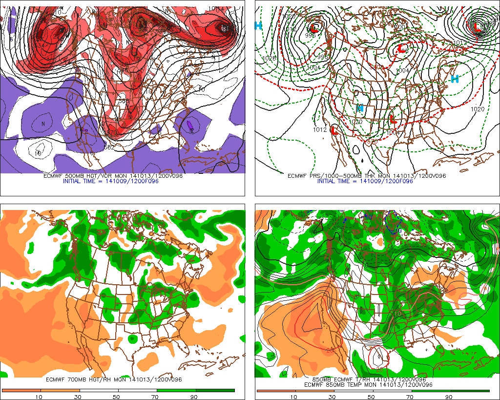
Forecast models continue to suggest strengthening low pressure will track northeast from MO into IL and MI Monday night into Tuesday morning.
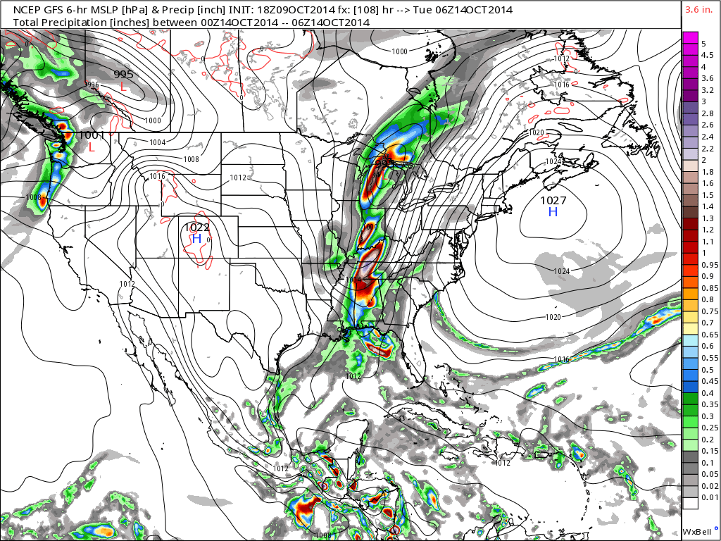
gfs_slp_precip_conus_19

f96

The region will briefly get into a warm and humid environment Monday and Monday night (plenty capable of fueling strong to severe thunderstorm development).  Temperatures in the 70s will combine with dew points in the low to mid 60s.
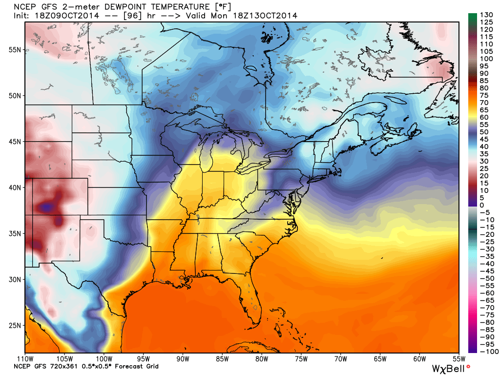
gfs_dew2m_east_33

A ribbon of precipitable water values will approach 2″ across the state Monday night.  This supports heavy and locally flash flood producing rainfall.  Forecast models continue to key on additional Monday-Tuesday rainfall in the 1-2″+ range.
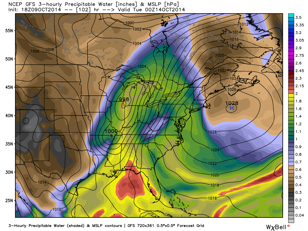
gfs_pwat_mslp_east_35

We’ll continue to closely monitor the data as we move forward, but at this early juncture, make a mental note to be weather-aware Monday night into Tuesday morning as strong to severe thunderstorm potential develops.

Not The Best Of Weather To Close The Work Week…

Thr.

Fri.

Sat.

Sun.

Mon.

Tue.

Wed.

 Status-weather-showers-scattered-icon

 Status-weather-showers-scattered-icon

 Status-weather-clouds-icon

 Status-weather-showers-day-icon

 Status-weather-showers-day-icon

 Status-weather-storm-night-icon

 Status-weather-showers-day-icon

50/ 59

49/ 57

41/ 59

44/ 62

59/ 72

52/ 65

43/ 59 

Not “Chamber Of Commerce” Weather…A frontal boundary will slip through the region this evening before stalling just south of Indianapolis.  An area of low pressure will move along the front Friday while chilly Canadian high pressure to our north tries to suppress things.  The battle ground will lie across central portions of the Ohio Valley.  Pack the rain gear and the cool weather attire.

Today, anticipate showers and rather gloomy conditions.  We’re not anticipating any sort of heavy rainfall across the region, but instead mostly light rain with embedded pockets of moderate rainfall.  Another push of rain will move into town Friday.  Heaviest rainfall should primarily fall along the I-70 corridor and points south Friday.  Total rainfall from today and Friday should range from 0.25″ to 0.50″ with some heavier totals possible downstate.

Not A Bad Weekend…We’ll likely get some dry time in this weekend as the region remains in between weather systems over the Saturday-Sunday period.  After a mainly dry Saturday, rain chances return Sunday.

Bigger Storm Early Next Week…A rather robust storm system will impact the region Monday night into Tuesday with heavy rain potential and the threat of strong to severe thunderstorms.  We’ll keep a close eye on things as we move through the weekend and update the forecast accordingly.

Upcoming 7-Day Precipitation Forecast:

  • 7-Day Rainfall Forecast: 2.00″ – 3.00″
  • 7-Day Snowfall Forecast: 0.00″ 

John Salewicz took this stellar photo of the lunar eclipse Wednesday morning.  Thanks, John!

BzcBzRZCYAAuueD


Our forecast radar products show another slug of moisture aimed at a Friday AM arrival.

Nice Today; Wet, Chilly Thursday On Deck…

Wed.

Thr.

Fri.

Sat.

Sun.

Mon.

Tue.

 Status-weather-clouds-icon

 Status-weather-showers-scattered-icon

 Status-weather-showers-scattered-icon

 Status-weather-clouds-icon

 Status-weather-showers-day-icon

 Status-weather-showers-scattered-icon

 Status-weather-storm-night-icon

44/ 66

47/ 55

51/ 55

42/ 58

48/ 62

61/ 70

49/ 64 

Much Needed Sunshine…After several days of wet, gloomy weather, sunshine will be a welcome sight to see!  Today is easily the pick of the week with dry skies and mild temperatures.  Enjoy!

Wet; Chilly End To The Work Week…A cold front will sink south into the area Thursday and rain will move into the state as early as the predawn hours Thursday morning.  Temperatures will actually fall Thursday afternoon and evening.  While there’s some “model mayhem” in regards to what takes place Friday, we’re currently leaning more towards the GFS/ NAM wet solution with a secondary wave of low pressure moving along the frontal boundary. Stay tuned.

Not A Bad Weekend…We’ll have to dodge a couple rain drops over the weekend (particularly Sunday), but it won’t be a wash-out by any means.  A chilly Saturday will slowly moderate Sunday.

Heavy Rain Event…Forecast models continue to key in on a heavy rain event impacting these parts Monday night into Tuesday of next week.  More details to come, but plan on the possibility of excessive rains across a large chunk of the Mid West and Ohio Valley at this early juncture.

Upcoming 7-Day Precipitation Forecast:

  • 7-Day Rainfall Forecast: 2.50″ – 3.00″
  • 7-Day Snowfall Forecast: 0.00″

Hopefully you were up early enough this morning to enjoy the lunar eclipse!  The first image is from the Brownsburg area and taken from Ronna Jessen.  Thank you, Ronna!  I also added an image taken off our back deck at 6:30 this morning.

unnamed


unnamed1

Tuesday Morning Rambles…

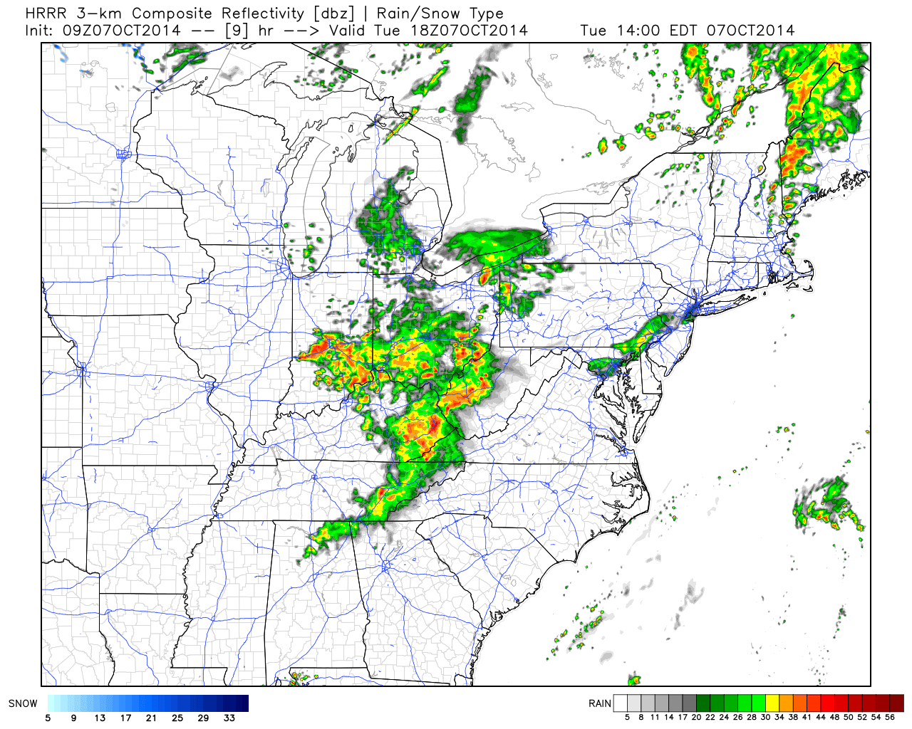
1.) We posted our weekly outlook last night and this can be found below.  An active weather pattern continues.  2.) A cold front will move through the region later this evening. As a result, showers and embedded thunder will be around into the afternoon hours before drier, cooler air builds in tonight behind the front.  Forecast radar shows rain and embedded storm chances continuing into the afternoon:

hrrr_ref_ma_10

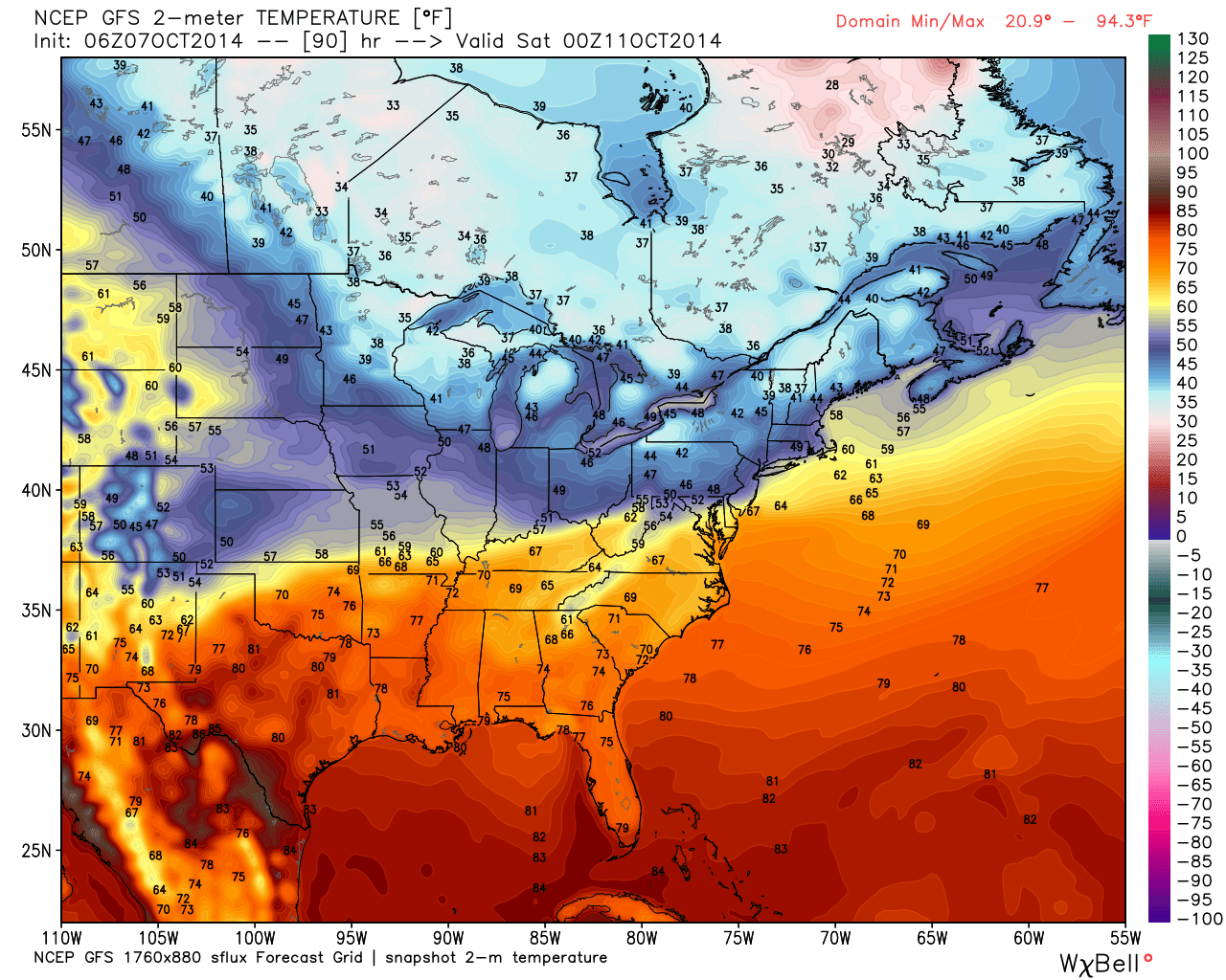
3.) Wednesday looks like the pick of the week with plentiful sunshine and pleasantly cool temperatures.  4.) Rain and storm chances return as early as Thursday into Friday.  5.) Friday stands to be quite an ugly day with rain chances and a new push of unseasonably chilly air.  A big thermal fight will be in place Friday as portions of northern Indiana don’t make it out of the 40s while temperatures across far southern areas of the state go into the 70s.  More specific to our region, look for falling daytime temperatures starting in the upper 50s.

gfs_t2m_east_31