 Highlights:
- Wet snow today
- New snow maker for Christmas Eve
- Turning bitterly cold
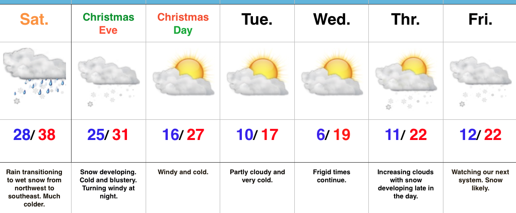
Festive Forecast…Rain changed to wet snow for northwestern ‘burbs between 4a-5a and the transition from wet to white will continue to progress southeast through the morning. A period of heavy, wet snow will fall through mid and late morning before precipitation begins to taper off. Our going snowfall forecast from yesterday continues to work with this event (for most it’s a slushy coating to 1″ in and around Indianapolis, increasing to a couple inches north). We experienced our high temperature for the day shortly after midnight.
Attention will then quickly shift to a new snow maker arriving Christmas Eve. The day will start dry, but snow will quickly develop as we progress into the afternoon. At times, snow will come down at a moderate clip and provide a classic setting for your festivities tomorrow evening. (We’ll have a fresh discussion posted later this afternoon for this event). Travel safely and leave extra time to reach your destination, as snow will accumulate on roadways. Additionally, we’ll add wind into the mix tomorrow night into Christmas Day with fresh cold air advection.
Speaking of Christmas, if you’re anticipating Santa to deliver outdoor gifts, you’ll want to plan to bundle up as you head out to enjoy the new toys. It’ll be a dry, but very cold Christmas.
Cold will remain the weather word to sum up next week and we’ll target the end of next week for the potential next winter event. It’s a busy, fun pattern if you like winter!
Upcoming 7-Day Precipitation Forecast:
- Snowfall: 3″ – 5″
- Rainfall: 0.00″
