Type: Impactful Wintry Weather

What: Accumulating snow and wind
When: Wednesday into Thursday morning
Temperatures: Middle 30s falling into the middle 20s by Wednesday night
Wind: North 15-25 MPH, increasing to 25-40 MPH Wednesday night and gusty
Blowing/ Drifting: Moderate to significant by Wednesday evening, continuing into Thursday morning
Pavement Impacts: Salting and plowing likely will be required

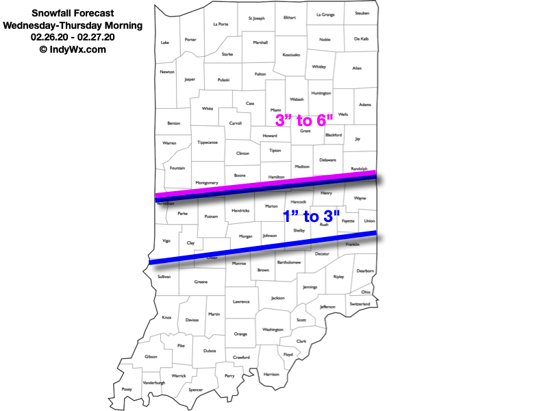
There has been a significant shift in the majority of model data today regarding the track of our midweek storm system. This has to do with a variety of elements, but most notably, the fact that the upper level energy at one time thought to come together to result in one primary storm during the first half of the work week, now looks to come in two parts: Monday into Tuesday, followed by a separate storm Wednesday into Thursday (this was what at one time was illustrated by the models a week+ ago). The debate now will continue for the next 24 hours around the deepening Storm #2 goes through, and this will have significant impacts on what central Indiana experiences in the Wednesday through Thursday time period. We think an initial wave of low pressure will organize along and just south of the Ohio River Tuesday night before tracking northeast and strengthening along the way into the eastern Great Lakes by Wednesday night. Should this, indeed, be the case, moisture would become widespread (after a relative “lull” Tuesday evening) across central Indiana Wednesday morning. With cold air funneling into the area by this time, the predominant precipitation type would fall as snow across central Indiana, including Indianapolis. Initially, this would be a wet type of snow before transitioning to a more powdery nature Wednesday evening.
As the storm begins to deepen to our northeast, blowing and drifting snow would become a concern on west-east roadways Wednesday evening into Wednesday night as the pressure gradient increases. By this time frame, north and eventually northwest winds would gust over 30 MPH with temperatures falling through the 20s. “System” snow would come to an end Thursday morning, but lake effect will continue across the traditional primary Snowbelt of northern Indiana (please note the amounts above do not account for the additional lake effect snow that would fall for Laporte, St. Joseph, and Elkhart counties). Additional lighter snow is a good bet for all as we close the work week out Friday, courtesy of upper level energy diving southeast across the state.
One additional note: We’ve been receiving a lot of questions around whether or not the southeast shift will continue with the model updates tonight. While some slight additional southeast movement in the axis of heaviest snow is still possible, there will be a limit due to the interaction between the deepening surface wave and area of high pressure. We will continue to keep a close eye on the data overnight and update things accordingly if needed early tomorrow morning.
Confidence: Medium
Next Update: Tuesday morning
