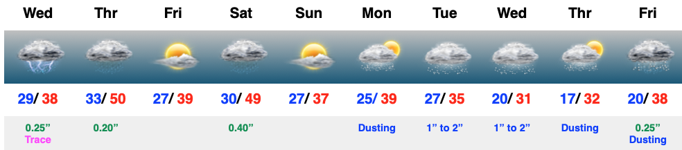
Category: Wintry Mix

VIDEO: Little Something For Everyone Over The Next Week…

Updated 03.05.22 @ 8:15a

You must be logged in to view this content. Click Here to become a member of IndyWX.com for full access.  Already a member of IndyWx.com All-Access?  Log-in here.

Permanent link to this article: https://indywx.com/2022/03/05/video-little-something-for-everyone-over-the-next-week/

VIDEO: Wintry Precipitation Overspreads The Area Yet Again This Afternoon Into The Evening…

Updated 02.24.22 @ 7:40a

Total snow and ice forecast between Wednesday night and Friday morning

Permanent link to this article: https://indywx.com/2022/02/24/video-wintry-precipitation-overspreads-the-area-yet-again-this-afternoon-into-the-evening/

Client Brief: (2) Waves Of Wintry Precipitation Set To Impact Area…

Updated 02.23.22 @ 5:15p

Type: Impactful wintry weather

A light mixture of snow and freezing rain will overspread the region during the evening, continuing into the overnight hours.

What: Impactful wintry weather

When: Tonight and Thursday morning and Thursday afternoon through predawn Friday 

Temperatures: Middle 20s to lower 30s

Wind: East Northeast 10-20 MPH, shifting to the north late Thursday

Blowing/ Drifting: Minimal across n-central Indiana

Pavement Impacts: Plowing and salting will be required across n-central Indiana and points north. Salting required across southern and central Indiana.

Summary: (2) waves of moisture will stream over central Indiana between this evening and predawn Friday. The initial, lead wave of precipitation will feature a mixture of light snow, light sleet, and light freezing rain. “Light” is the key word, but area roadways will likely become slick through the evening and into tonight- including in and around Indianapolis-proper. In and around the I-70 corridor and points north, this precipitation is expected to primarily fall in the form of snow. Further south, a mixture of sleet and freezing rain is anticipated. While this will be light in nature, precipitation should be rather persistent, lasting up until, or just after, sunrise. By sunrise, areas in and around Indy and points north can expect between 0.50″ and 1.50″ of snow (should sleet mix in, amounts will be closer to the lighter end of the spectrum vs. if we stay mostly snow, amounts closer to 1.5″ can be expected). Further south, a light glaze (up to 0.1″) and light sleet is expected to be the predominant precipitation type with this initial wave of moisture.

We’ll then undergo a “lull” in the action mid morning into the early afternoon hours, but low pressure will be organizing off to our southwest and have eyes set on a northeast trek into the southern portion of the state Thursday evening. This will be when we anticipate the heavier precipitation to move across the region. Across southern IN, this should primarily fall in the form of a cold rain, but further north the same can’t be said: a wintry mix of sleet and freezing rain is expected to redevelop Thursday afternoon and continue into the night before ending as light snow. Across n-central IN and points to the MI/ IL state line, all snow is anticipated.

Precipitation will diminish from southwest to northeast predawn Friday with high pressure regaining control of our weather to close out the work week (just a few light lingering snow showers are expected Friday). Please see our updated snow and ice forecast below that includes total amounts for both parts of this event.

Confidence: High

Next Update: 7:30a Thursday

Permanent link to this article: https://indywx.com/2022/02/23/client-brief-2-waves-of-wintry-precipitation-set-to-impact-area/

VIDEO: Detailed Look At Timing And Precipitation Type Challenges Ahead Over The Next 24-48 Hours…

Updated 02.23.22 @ 7:34a

Permanent link to this article: https://indywx.com/2022/02/23/video-detailed-look-at-timing-and-precipitation-type-challenges-ahead-over-the-next-24-48-hours/

Quick Pre-Dinner Note On Thursday-Friday Morning…

Updated 02.22.22 @ 5:21p I. After digesting the 12z model suite, it continues to look like an impactful winter event is still slated to impact the state Thursday and into…

You must be logged in to view this content. Click Here to become a member of IndyWX.com for full access.  Already a member of IndyWx.com All-Access?  Log-in here.

Permanent link to this article: https://indywx.com/2022/02/22/quick-pre-dinner-note-on-thursday-friday-morning/

VIDEO: Embedded Thunder And Spring-Like Today; Concern Growing For Potential Of Significant Icing Across A Portion Of The Region Thursday…

Updated 02.22.22 @ 7:24a

You must be logged in to view this content. Click Here to become a member of IndyWX.com for full access.  Already a member of IndyWx.com All-Access?  Log-in here.

Permanent link to this article: https://indywx.com/2022/02/22/video-embedded-thunder-and-spring-like-today-concern-growing-for-potential-of-significant-icing-across-a-portion-of-the-region-thursday/

Midday Video Update: Fresh Thoughts As 12z Data Strolls In…

Updated 02.21.22 @ 1:54p

You must be logged in to view this content. Click Here to become a member of IndyWX.com for full access.  Already a member of IndyWx.com All-Access?  Log-in here.

Permanent link to this article: https://indywx.com/2022/02/21/midday-video-update-fresh-thoughts-as-12z-data-strolls-in/

VIDEO: Taste Of Spring To Open The Work Week; Another Impactful Winter Event To Close The Work Week…

Updated 02.21.22 @ 7:38a

While we still need another day or two to hammer out specific numbers, here’s the early thinking around precipitation type with system #2 (Wednesday night into Friday morning).

Permanent link to this article: https://indywx.com/2022/02/21/video-taste-of-spring-to-open-the-work-week-another-impactful-winter-event-to-close-the-work-week/

VIDEO: Spring-Fling To Open The Week; New Winter Storm Threat Arrives Late Week…

Updated 02.20.22 @ 8:43a

You must be logged in to view this content. Click Here to become a member of IndyWX.com for full access.  Already a member of IndyWx.com All-Access?  Log-in here.

Permanent link to this article: https://indywx.com/2022/02/20/video-spring-fling-to-open-the-week-new-winter-storm-threat-arrives-late-week/

VIDEO: Tracking (2) Systems Next Week…

Updated 02.19.22 @ 7:45a

You must be logged in to view this content. Click Here to become a member of IndyWX.com for full access.  Already a member of IndyWx.com All-Access?  Log-in here.

Permanent link to this article: https://indywx.com/2022/02/19/video-tracking-2-systems-next-week/

IndyWx.com