
 Highlights:
- Bye-bye thaw
- Ice to snow Friday
- Second snow maker Sunday night
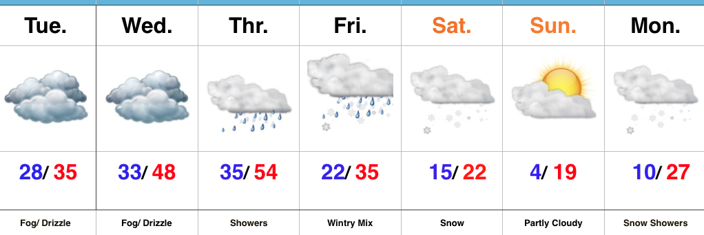
Active Forecast Period…A breezy southerly flow will dominate our weather today ahead of an approaching cold front. Showers and unseasonably mild conditions can be expected today. (Despite the snow lover in me, I will admit that it’s been mighty nice being able to jog outside without worrying about slipping on ice or snow the past couple days).
Things begin to change in rather dramatic fashion tonight as the cold front presses through the state and allows much colder air to “ooze” back into central Indiana. At the same time, a wave of energy will track northeast along the cold front and help spread more widespread moisture into the colder air at the surface. We expect rain to begin mixing with and changing to an icy mixture of sleet and freezing rain after midnight across western and central portions of the state, and closer to 5a-6a across eastern Indiana. Eventually, as the entire column of air cools, icy precipitation will transition to snow. If the sleet to snow transition occurs faster, snowfall totals will be at the higher end of the first call numbers outlined below. Should sleet hold on for a longer period of time, snowfall amounts will be on the lower end of forecast totals. We think snow will end around noon west of the city, but steady snow will hang on much longer across eastern sections of the viewing area- well into the evening hours.
Here’s our first call snowfall forecast for Friday. While this doesn’t include freezing rain amounts, we think a glaze up to 0.10″ is a good bet – especially on elevated and exposed surfaces.
 Dry conditions will return Saturday along with a much colder feel. Quiet times won’t last long as another snow system will quickly begin to impact the state Sunday evening into Monday. Widespread steady snow is expected to develop and will actually be a more uniform, bigger, event for most of the viewing area. We’ll add in wind and arctic air which will lead to blowing and drifting issues as the day progresses Monday into Tuesday. Here’s our first call for additional snow amounts Sunday evening-Monday.
 The forecast period will wrap up dry and bitterly cold. With a fresh snowpack down, it’s safe to say we’ll add at least another night to the sub-zero “club!”
Stay tuned, friends!
Upcoming 7-Day Precipitation Forecast:
- Snowfall: 3″ to 6″
- Rainfall: 0.25″ to 0.75″
*Please note the 7-day precipitation forecast outlined above is for Indianapolis proper.
 Highlights:
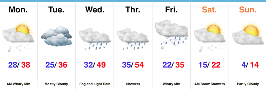 Highlights: