
You must be logged in to view this content. Click Here to become a member of IndyWX.com for full access. Already a member of IndyWx.com All-Access? Log-in here.
Category: Wintry Mix
Permanent link to this article: https://indywx.com/video-quiet-open-to-the-week-gives-way-to-a-busy-close/
Jan 02
Fresh Short-Term Update; Longer Range Rambles…
Dry air continues to “eat away” at the advancement of precipitation northward this afternoon. It now appears as if we’ll escape rain-free through the evening hours, with steadier rain lifting north into central Indiana towards 10p to 11p.
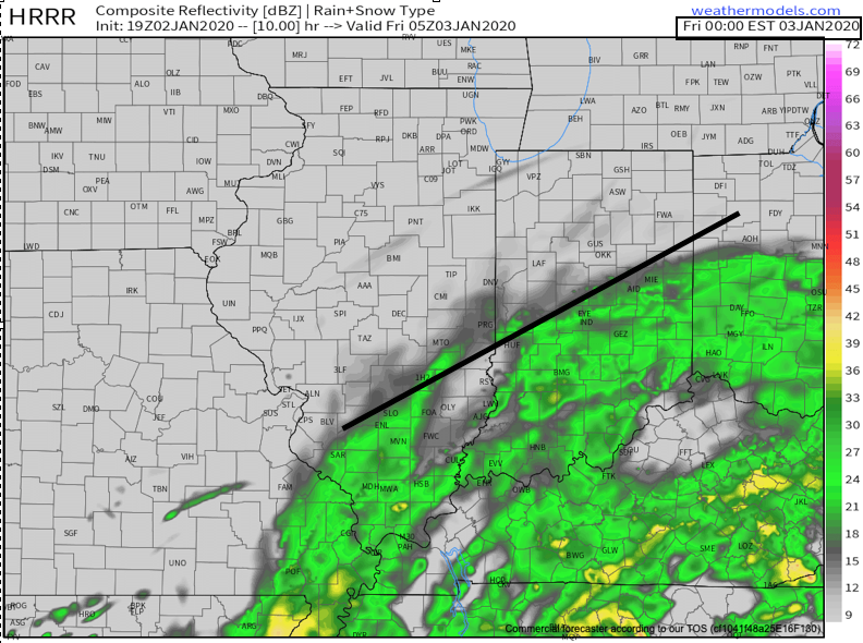
Heaviest totals still look like they’ll fall across southeastern Indiana (amounts up to 1″ possible) with lighter amounts of .20″ to .40″ across the more immediate area.
Most of the daytime Friday will feature a lack of significant rain, but there could be some drizzle and spotty light shower activity around at times.
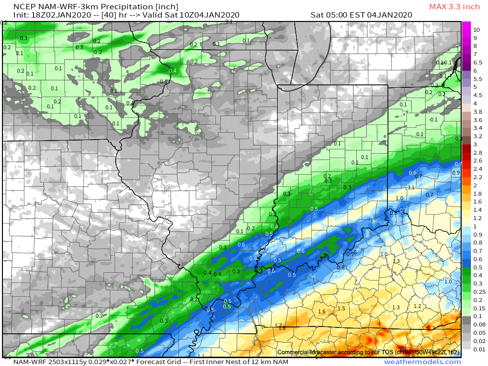
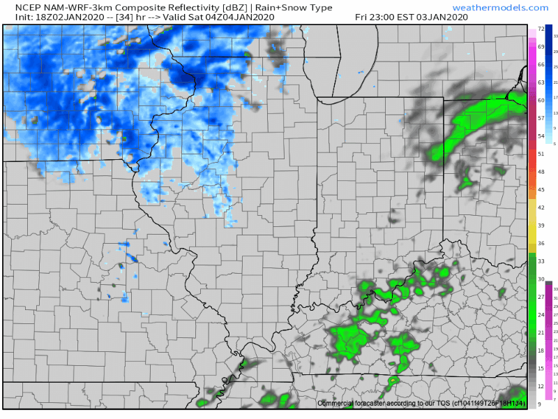
It’s as we get into Saturday morning that we need to monitor the track of vigorous upper level energy moving southeast out of the northern Plains and into the lower Ohio Valley. In response to this, an expanding area of snow and/ or mixed precipitation should initially develop across Iowa before building into Indiana prior to sunrise. These systems are admittedly tricky and can spawn surprises and we’ll keep close eyes on things over the next 24-36 hours. As things stand now, I would place the best chances of accumulating snow from Iowa, northern IL, northern IN, and into northern OH with this system, but please stay tuned.
The next weather maker, locally, will likely be responsible for another opportunity of snow Tuesday into Wednesday.
In a way it’s ironic we’re looking at back-to-back opportunities of sticking snow in what’s a warmer than average pattern. This, of course, is on the heels of December’s above average snowfall month. Central Indiana snowlovers know all too well that frigid patterns can be bone dry around these parts…
Longer range hinges squarely on the shoulders of the MJO. Things are highly amplified and will result in one of two scenarios- swinging out of the warm phases and into the traditionally cold phases for mid-winter after mid-month, or circle back through Phase 5. If it’s the latter, anomalous warmth would continue across the east while significant cold takes up shop across the west. In January, Phase 5 is the last thing eastern fans of winter want to see.
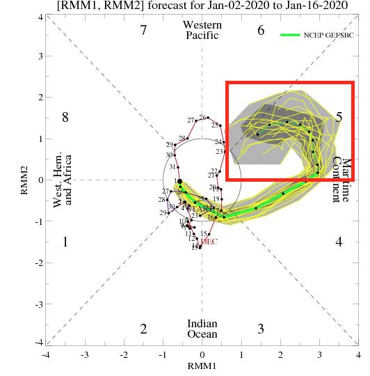
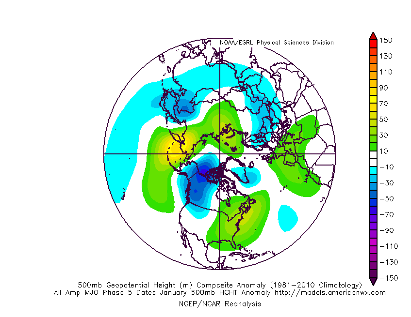
As it is, I continue to believe the favorable northeast Pacific will have the final say on this winter with a more favorable regime developing during the 2nd half of January that would pull the cold into the region in more sustained fashion (next 10-14 days will feature transitional cold along with the stormy pattern).
The latest European Weeklies may be starting to see this as the relative warmth in Week 2 gives way to colder times Week 3.

A very active pattern is set to remain intact over the next 2-3 weeks and even in the warm patterns, snow and wintry mix events can prove to be a headache this time of year.
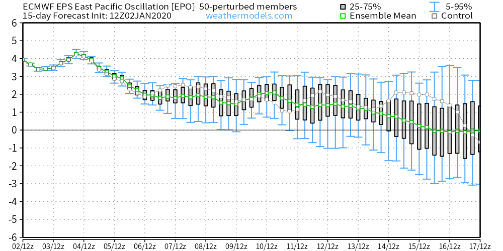
Both the GEFS and EPS show the EPO moving from a strongly positive phase now (also argues for the warmer than overall pattern in the immediate-medium term) towards neutral to negative after mid-month. We’ve been noticing the tendency both models have had trying to drive the negative EPO too quickly (recall only a few days ago the models wanted to develop the negative EPO around the 12th or 13th).

Rest assured, our eyes will be glued to the MJO and EPO through the 2nd half of the month. Time will tell if the highly anticipated favorable warm northeast Pacific SSTs will begin to do the trick…
Permanent link to this article: https://indywx.com/fresh-short-term-update-longer-range-rambles/
Dec 16
Client Brief: Heavy Snow Bands Return Into The Overnight…
Type: Impactful Wintry Weather

What: Accumulating snow; mixed wintry precipitation
When: This evening into Tuesday morning
Temperatures: Lower to middle 30s, falling into the middle 20s Tuesday morning
Wind: Northeast shifting to the northwest Tuesday morning
Blowing/ Drifting: Minimal
Pavement Impacts: Plowing and salting will be required.
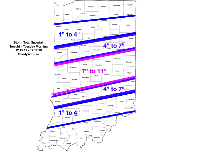
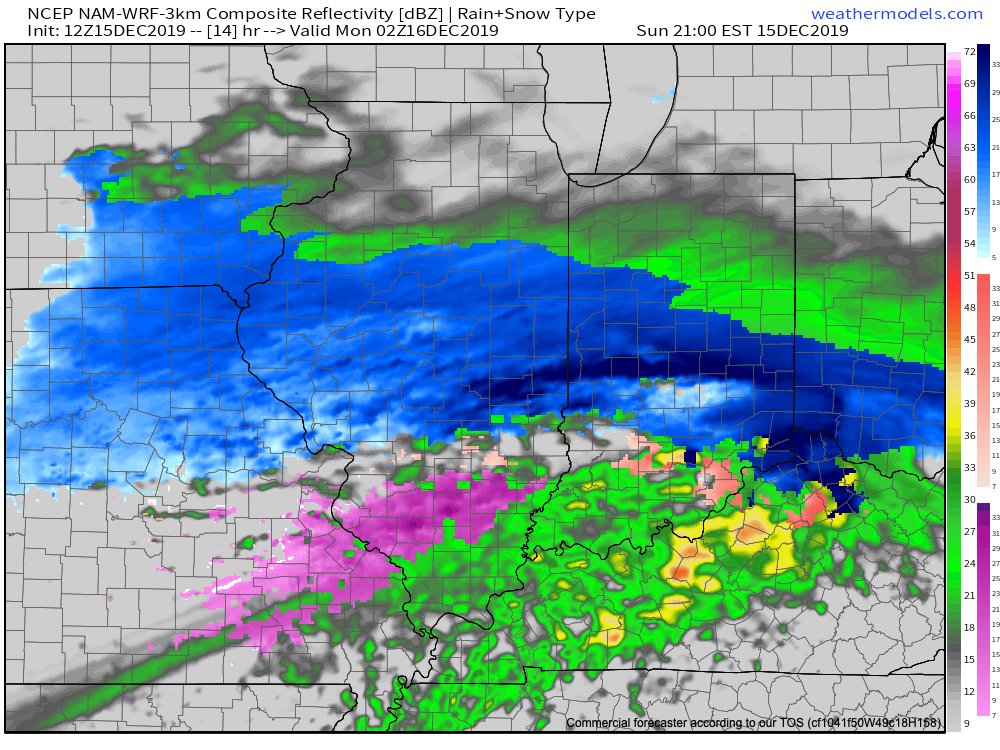
“Round 2″ is underway and we actually believe the overall snow shield will become more expansive with time through the late evening and overnight hours. Within this growing snow shield, embedded banding is expected that will include moderate to heavy snowfall rates. This continues to look like an I-70 special with respect to heaviest totals (7″ to 11″ range for storm totals). On either side of that heaviest snow zone, 4″ to 7” can be expected. On the north side, this is due to lighter intensity of snow (both with Part 1 and Part 2) and mixing issues on the south side.
Snow will exit the city just before daybreak, and southeast Indiana between 8a and 9a. Winds will shift to the northwest and an overall colder day is expected Tuesday, but at least we won’t have to worry about additional snow once past daybreak.
Cold air reinforcements will blow into town Wednesday with a couple snow showers across east-central Indiana. The bigger deal will be the cold, including temperatures that will remain stuck in the middle 20s through the daytime hours. Add in a stiff breeze and wind chill values will be in the 10s.
Confidence: High
Next Update: Tuesday morning
Permanent link to this article: https://indywx.com/client-brief-heavy-snow-bands-return-into-the-overnight/
Dec 15
Client Brief: Updated Snowfall Forecast; Conditions Go Downhill Quickly This Evening…
Type: Impactful Wintry Weather
What: Accumulating snow; mixed wintry precipitation
When: This evening and Monday afternoon – Tuesday morning
Temperatures: Lower to middle 30s, falling into the middle 20s Tuesday morning
Wind: East northeast 10 to 15 MPH, shifting to the northwest Monday night with gusts to 25 MPH
Blowing/ Drifting: Minimal
Pavement Impacts: Plowing and salting will be required.

Right out of the gate, let’s talk accumulation: While we don’t need to make significant changes to the snowfall forecast, we did “tighten” the 3″ to 6″ band up a bit and scaled the 1″ to 3″ zones closer into central Indiana on both the north and south sides. This continues to be a central Indiana event- at least as far as heaviest snowfall totals go.
This event will still come in 2 waves, but it now appears as if the initial surge of moisture this evening and tonight will feature the heaviest snowfall rates. Snow will overspread the region this evening (arriving into Indianapolis, itself, between 6p and 7p) and come down heavily at times through the overnight hours. Part 1 will end before daybreak, but the damage will have been done by that point and the morning commute will be significantly impacted as central Indiana digs out from 3″ to 5″ of wet snow.
We’ll get a break through the bulk of the daytime Monday, but precipitation will once again overspread the region from southwest to northeast Monday evening, continuing into the predawn hours Tuesday. This will take the form of snow across central Indiana with a wintry mix and/ or a cold rain across southern and southeastern Indiana. An additional coating to 1″ of snow is possible with this 2nd wave of moisture.
Finally, winds will shift to the northwest and drive colder air into the state Monday night behind the departing storm. Everyone (including southeastern Indiana) will be below freezing Tuesday morning with additional travel impacts likely.
Confidence: High
Next Update: This evening
Permanent link to this article: https://indywx.com/client-brief-updated-snowfall-forecast-conditions-go-downhill-quickly-this-evening/
Dec 14
VIDEO: 2-Part Storm Sunday Evening-Tuesday Morning; Active Times Through The Holiday Season…
You must be logged in to view this content. Click Here to become a member of IndyWX.com for full access. Already a member of IndyWx.com All-Access? Log-in here.
Permanent link to this article: https://indywx.com/video-2-part-storm-sunday-evening-tuesday-morning-active-times-through-the-holiday-season/