Category: Wintry Mix

02.19.21 Weather Bulletin: 13 Days And Counting…

Updated: 02.19.21 @ 7:55a

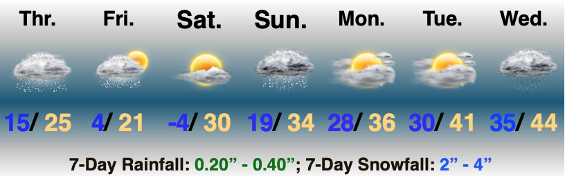
Cold Times Persist Into The Weekend…It’s been 13 full days since we last saw anything close to the freezing mark and we’ll tack on a couple more days before we inch back up above freezing Sunday. This has been an impressive cold stretch (likely longest since back in 2007).

While we’ll see some early sunshine today, clouds will begin to increase through the afternoon and will eventually yield some light snow showers as we move into later tonight and Saturday. The positive in these clouds? It’ll keep us in the “balmy” single digits (as opposed to the once thought 0° to 5° below zero range) to open up our Saturday.

A slightly stronger system will arrive on the scene Sunday afternoon and evening and you know the fear here: that we will be looking at icing issues Sunday PM. Even with temperatures expected to be a couple degrees above freezing, given the strength and magnitude of the cold as of late, the concern is that any sort of liquid precipitation will freeze on the surface. I’d plan on potentially slick travel across the region Sunday evening as this system blows through. Precipitation should arrive mostly after 4p and while we’re not talking about plentiful amounts (0.2″ to 0.4″ for most), it doesn’t take much to create problems.

A gusty westerly breeze will then greet us to open the new work week and this will blow relatively milder air into the region into midweek before a cold front settles south and returns the chill for late next week. As this takes place, we’ll have to keep our eyes to the southwest for the possibility of another more significant winter feature impacting the general area just beyond the current 7-day period.

Averages: H: 41°/ L: 25° on the 19th –> H: 44°/ L: 27° on the 25th

Permanent link to this article: https://indywx.com/02-19-21-weather-bulletin-13-days-and-counting/

VIDEO: Long-Winded Update Of Where We Think The Pattern Is Going Into Early March…

Updated: 02.18.21 @ 7:08p

You must be logged in to view this content. Click Here to become a member of IndyWX.com for full access.  Already a member of IndyWx.com All-Access?  Log-in here.

Permanent link to this article: https://indywx.com/video-long-winded-update-of-where-we-think-the-pattern-is-going-into-early-march/

02.18.21 Weather Bulletin: Another Snowy Day…

Updated 02.18.21 @ 8:38a

More Shoveling Ahead…Widespread snow continues to blanket central Indiana and this will remain the case through early afternoon. Throughout immediate central Indiana, reports indicate we’ve already seen 2″ to 3″ for most and we’ll likely tack on an additional 1″ to 2″ before the steady snow exits early afternoon. (Please keep those reports coming by sending to us via Twitter @indywx or email bill@indywx.com. As always, your ground-truth reports are invaluable- and greatly appreciated)!

“System” snow will diminish from southwest to northeast this evening and arctic reinforcements arrive on the scene tonight and Friday. Additional snow flurries and scattered snow showers are a good bet Friday, but with minimal additional accumulation.

As high pressure builds overhead Friday night and Saturday morning, we’ll likely “go low” on the thermometer and rival numbers seen around these parts Wednesday morning. Sunshine and just enough return flow around that area of high pressure will go a long way to helping us out Saturday afternoon though as we forecast a “balmy” 30° ;-).

Our next storm system will blow through here Sunday into Sunday night. You know our concern. Despite forecast model data trying to warm things up, I’m afraid data still isn’t understanding the situation at hand, especially given the prolonged nature and magnitude of the cold. We’ll continue to keep a close eye on things, but as it sits now, I’m still very much concerned we’re looking at more of a wintry mix/ icing type event Sunday PM as opposed to a cold rain the majority of data currently shows.

Next week will open on the milder side of things, but we’re already eyeing the next possible round of wintry “mischief” late next week…

More on all of this, including a longer range update later this evening in our video discussion.

Permanent link to this article: https://indywx.com/02-18-21-weather-bulletin-another-snowy-day/

02.17.21 Weather Bulletin: Snow Returns; Keeping An Eye On Sunday…

Updated 02.17.21 @ 8:06a

Snow Builds Back In…As easy as the previous storm was, this one has been a royal pain in the neck. Stubbornly, I anticipated a further northwest shift (especially given the PNA state), but that’s not to be the case. While southern and southeastern Indiana will tack on a few additional inches with this storm, this is a 1″ to 2″ type deal for central Indiana, and most of that falls tomorrow morning into Thursday afternoon.

A few lingering light snow showers are possible Friday followed by clearing. High pressure will build overhead Friday night and set us up for another “nasty” cold night. Temperatures will likely rival where we are this morning come Saturday morning as winds go calm and skies clear.

The next potential trouble maker looms on the horizon Sunday. Models are beginning to slowly understand that we’re simply not going to dislodge all of this cold air in quick fashion. As such, a wintry mix and/ or wet snow is becoming increasingly likely by Sunday PM into Sunday night as this system blows through.

Quiet conditions return into early portions of the work week.

Averages: H: 41°/ L: 24° on the 17th –> H: 43°/ L: 26° on the 23rd

Permanent link to this article: https://indywx.com/02-17-21-weather-bulletin-snow-returns-keeping-an-eye-on-sunday/

02.15.21 Weather Bulletin: Hunker Down…

Updated 02.15.21 @ 7:20a

Be At Your Destination By Early Afternoon…Light snow continues to fall across the region this morning, but conditions will deteriorate rapidly as we move just beyond the lunchtime hour. Snowfall will become heavy and accumulate to the tune of 1″ to 2″ per hour this afternoon and tonight. By Tuesday morning, we expect many central Indiana communities to be closing in on a foot, and drifts in the open country will exceed 3 feet in spots. We highly discourage travel today if at all possible. If you have to travel this afternoon and evening, please ensure you have a winter storm survival kit packed as many roadways will become impassable due to a combination of very heavy snow and increasing wind. Speaking of wind, northeasterly gusts will top 35 MPH this evening, leading to severe drifting. Our snowfall forecast remains unchanged from yesterday.

Clean up from storm 1 should begin Tuesday morning as another winter storm has eyes on the region Wednesday night through Thursday. Despite a few lingering light snow showers Tuesday morning, a period of quieter conditions will develop for about 24 hours from Tuesday afternoon into Wednesday afternoon. Though it’ll still be much colder than normal, sunshine will return.

Our next storm system will come roaring out of the northwest Gulf Wednesday night, tracking northeast, up along the western slope of the Appalachians Thursday into Thursday night. You know the drill: this is a favorable track for another heavy snow storm and we expect adding several more inches onto our growing snowpack during this time frame. Stay tuned as we issue our snowfall forecast for Storm #2 later today.

Looking further ahead, it finally looks like we’ll climb out of the deep freeze by the 2nd half of the weekend. The problem? Another storm system will be approaching with snow and/ or a wintry mix.

Permanent link to this article: https://indywx.com/02-15-21-weather-bulletin-hunker-down/