You must be logged in to view this content. Click Here to become a member of IndyWX.com for full access. Already a member of IndyWx.com All-Access? Log-in here.
Category: Wintry Mix
Permanent link to this article: https://indywx.com/2018/01/07/video-icy-snow-night-ahead-late-week-winter-storm/
Jan 05
VIDEO: Wintry Mess By Sunday Night; Don’t Put Us In The Winter’s Over Camp…
You must be logged in to view this content. Click Here to become a member of IndyWX.com for full access. Already a member of IndyWx.com All-Access? Log-in here.
Permanent link to this article: https://indywx.com/2018/01/05/video-wintry-mess-by-sunday-night-dont-put-us-in-the-winters-over-camp/
Jan 05
Friday Morning Rambles…
I. Bitter Cold: We’re adding another morning below zero to an already impressive (and growing) list of frigid lows this winter. Take a look at these morning lows in the…
You must be logged in to view this content. Click Here to become a member of IndyWX.com for full access. Already a member of IndyWx.com All-Access? Log-in here.
Permanent link to this article: https://indywx.com/2018/01/05/friday-morning-rambles-4/
Jan 04
VIDEO: Wintry Threats On Deck & Looking Deeper Into January…
You must be logged in to view this content. Click Here to become a member of IndyWX.com for full access. Already a member of IndyWx.com All-Access? Log-in here.
Permanent link to this article: https://indywx.com/2018/01/04/video-wintry-threats-on-deck-looking-deeper-into-january/
Jan 04
Frigid Times; Watching Sunday…
 Highlights:
- Fresh batch of arctic air served up
- Watching Sunday
- Moderating next week
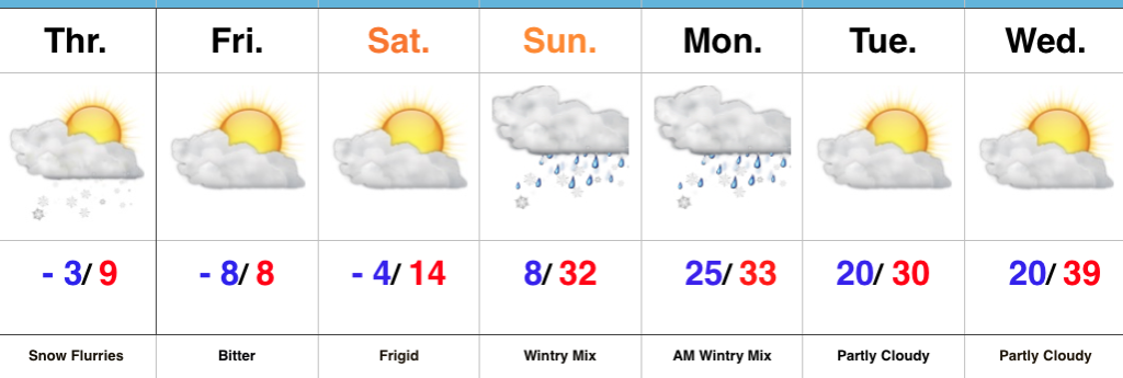
Brutal Cold Continues…A fresh batch of arctic air arrived into the Hoosier state last night. This will set the stage for an absolutely frigid close to the week. Wind chill values will periodically reach dangerous levels between now and Saturday morning. Additionally, we’ll add a few more mornings to the sub-zero club in what’s already an impressive list this winter.
Attention remains on a developing storm system that will impact our region Sunday into early Monday. We forecast a lowering and thickening cloud deck to arrive overnight Saturday into Sunday morning, followed by a wintry mix Sunday afternoon and evening. Messy wintry precipitation should continue into early Monday before precipitation departs to our east. Data, overall, has trended colder over the past 24 hours and would lead to more impact from snow and less ice. Stay tuned.
Drier times return early next week along with moderating conditions ahead of the next storm system that will approach late next week.
Upcoming 7-Day Precipitation Forecast:
- Snowfall: 1″ to 3″
- Rainfall: 0.00″
Permanent link to this article: https://indywx.com/2018/01/04/frigid-times-watching-sunday/
Dec 15
Unseasonably Pleasant Open To The Weekend…
 Highlights:
- “Can’t beat it” weather for mid-December
- Raw second half of the weekend
- Changes loom
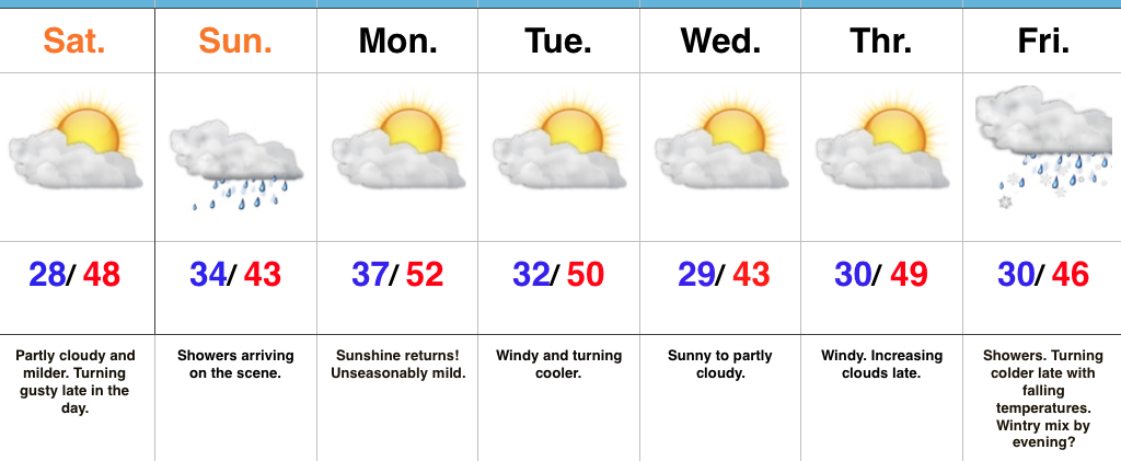
Great Open To The Weekend…High pressure and a relatively mild southwest flow will help boost temperatures to near 50° Saturday afternoon, complete with plentiful sunshine. We will note an increasingly gusty southwest breeze late in the day.
The second half of the weekend will feature an increasingly wet period, along with a “raw” feel. Rainfall amounts won’t be particularly impressive, but rain gear will be required on the way out to church Sunday morning.
High pressure will quickly build back in thereafter and remain in control of our work week weather. A nice stretch of pleasant conditions (by mid-December standards) will prevail, including plentiful sunshine. Enjoy it as big changes loom.
The all-important Christmas-New Years period is growing ever closer and data continues to suggest we should gear up for busy times in the forecast office. An active pattern looms, including one that will trend progressively colder.
Upcoming 7-Day Precipitation Forecast:
- Snowfall: 0.00″
- Rainfall: 0.10″ – 0.25″
Permanent link to this article: https://indywx.com/2017/12/15/unseasonably-pleasant-open-to-the-weekend/
Mar 17
Gloomy St. Patrick’s Day Gives Way To A Brighter Weekend…
 Highlights:
- Wet, raw St. Patrick’s Day
- Brighter weekend ahead
- Shower chances return next week
Weekend Improvements Ahead…Today won’t be the classic “chamber of commerce” weather day across central Indiana. A brief wintry mix impacted central and eastern portions of the state earlier this morning and will give way to “showery” weather with blustery conditions and an overall raw feel. It won’t rain the entire day, but plan on packing the wet weather gear as you venture out to your March Madness and St. Patrick’s Day parties. Stay safe out there!
Drier times will return for the weekend as high pressure slowly builds overhead. Saturday will feature a couple of showers- especially across eastern portions of the state through the early afternoon. However, brighter conditions will develop late in the day and by Sunday, mostly sunny skies will return. Along with the increasing Sunday sunshine, temperatures will top 50° for the first time since March 8th.
Unfortunately the sunshine won’t last into the early stages of the work week as moisture returns and showers follow Monday into Tuesday. We’ll turn briefly colder Wednesday before a moist southerly flow returns Thursday with another round of showers.
Upcoming 7-Day Precipitation Forecast:
- Snowfall: 0.00″
- Rainfall: 0.50″ – 1.00″
Permanent link to this article: https://indywx.com/2017/03/17/gloomy-st-patricks-day-gives-way-to-a-brighter-weekend/
Mar 11
Winter Finally Shows Up…
 Highlights:
- Much colder than average
- Snow prospects to open the week
- Busy pattern continues
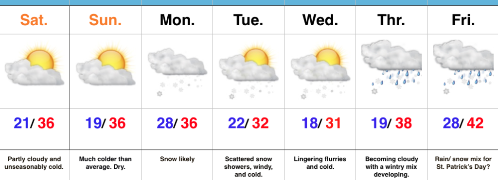
Locked In A Cold Pattern…The stretch of spring-like, unseasonably warm, conditions we enjoyed through most of February and to open March will be all but a distant memory once to this time next week. A major reversal to a colder than normal pattern is now with us and will feature lows into the teens on a few nights over the upcoming week.
Additionally, we continue to highlight the fast-moving northwest flow aloft. This kind of regime wrecks havoc on forecast models and, accordingly, we have lower than normal confidence in the specifics late in the work week. Stay tuned.
Before we get to late week, we have a disturbance (that will eventually help feed a blockbuster Nor Easter) that will deliver snow as we open up the work week. This time of year, snow intensity and time of day mean a world of difference between an accumulating event, or not. Snow should overspread central Indiana before sunrise Monday and will likely accumulate before the higher sun angle takes over and lighter snowfall rates result in a lack of daytime accumulation. As reinforcing cold air filters in Monday night, additional light accumulation will be possible in scattered heavier snow showers that will continue into Tuesday. All-in-all, this doesn’t appear to be a huge event, but a few slick spots will be possible Monday morning before that higher March sun angle gets to work. We’ll keep a close eye on things.
Moving forward, we’re confident on the overall colder than normal pattern that will continue into Saint Patrick’s Day, but, as mentioned above, fine tuning will be required with the potential of a late week storm system to contend with.
Upcoming 7-Day Precipitation Forecast:
- Snowfall: 1″ – 3″
- Rainfall: 0.25″ – 0.50″
Permanent link to this article: https://indywx.com/2017/03/11/winter-finally-shows-up/
Jan 13
Quick Friday Evening Notes…
1.) While we’re still expecting freezing rain across central Indiana tonight into the early morning hours Saturday, dry air will really limit totals. Instead of the 0.10″-0.20″ of glaze per…
You must be logged in to view this content. Click Here to become a member of IndyWX.com for full access. Already a member of IndyWx.com All-Access? Log-in here.
Permanent link to this article: https://indywx.com/2017/01/13/quick-friday-evening-notes/
Jan 08
Changeable Weather; Late Week Ice Threat…
 Highlights:
- Another bitter day
- Moderating temperatures ahead
- Late week ice threat looms
Bitter Cold Gives Way To Moderating Temperatures…The first half of the forecast period is easy, but we caution big time headaches loom and details are far from etched in stone once to the second half of this forecast period.
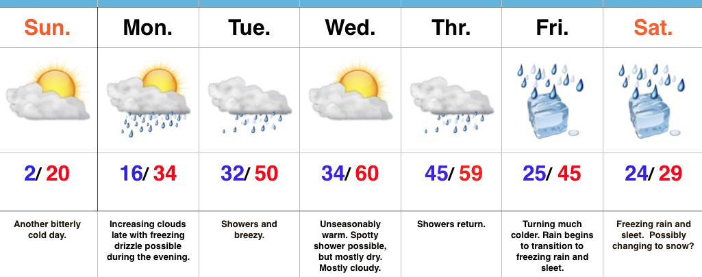
First thing’s first and that’s today. Look for a continuation of bitterly cold air, but slow moderation will be noted this afternoon: Not AS bitter and lighter winds. We may even crack the 20 degree mark! I know, break out the swim suits, right?! This moderating trend is setting the tone for a more significant jump in the mercury later in the week. Before a “taste of spring” arrives, we’ll have to deal with a brief opportunity for freezing drizzle Monday evening. Temperatures will zoom to around 50 Tuesday and around 60 for mid week. Showers will be with us off and on- focused on Tuesday and Thursday for most widespread coverage.
Then comes the “fun.” A strong, sprawling arctic high will push south into the northern Plains Friday. At the same time, “resistance” from the southeast ridge (that can be thanked for the spring-like feel here Wednesday and Thursday) will result in the arctic front only slowly being able to push south. Ripples of energy, or waves of low pressure, will move along the arctic boundary and result in periods of widespread precipitation Friday into the weekend. As the cold, dense arctic air oozes south, we have concern for icing- freezing rain and sleet Friday into Saturday. Depending on how things evolve, this may continue into Sunday, as well. If you have travel plans this weekend, please keep a close eye on the developments in the forecast from Friday on. Stay tuned.
Upcoming 7-Day Precipitation Forecast:
Snowfall: 1.00″
Rainfall: 1.50″ – 2.00″
Permanent link to this article: https://indywx.com/2017/01/08/changeable-weather-late-week-ice-threat/
