Updated 01.19.24 @ 7:58a As the “system” snow winds down, we’ll notice a renewed area of snow showers developing through the late morning and afternoon as another round of arctic…
You must be logged in to view this content. Click Here to become a member of IndyWX.com for full access. Already a member of IndyWx.com All-Access? Log-in here.
Updated 01.17.24 @ 6:58a A band of snow will drop south into north-central IN Thursday morning, likely making it as far south as the Indianapolis-area proper before falling apart. This…
You must be logged in to view this content. Click Here to become a member of IndyWX.com for full access. Already a member of IndyWx.com All-Access? Log-in here.
Permanent link to this article: https://indywx.com/video-snowy-close-to-the-week-finally-arctic-hammer-drops-this-weekend-before-significant-pattern-change/
Today and most, if not all, of Wednesday will be plain ole cold but at least precipitation free. We’ll have to watch short term guidance closely for a band of snow that will develop across northern Indiana overnight and into Thursday morning. We think this snow band will sink south into at least north-central Indiana after sunrise Thursday before falling apart likely around Indianapolis. A quick 1”-2” of snow is likely across northern and north-central Indiana Thursday morning.
Our next opportunity of snow (area wide) will move in Thursday night and Friday morning. This will be a much higher ratio type snow (think 20:1) than typical with the cold, arctic airmass in place. We should easily be able to accumulate 2”-4” with this event, with the potential of a couple 4”+ reports. (Snow removal clients, plowing and salting will be activated by Thursday evening).
A fresh round of bitter, arctic air flows in as we kick off the weekend. With a fresh snowpack, another round of subzero lows should be expected. Look for highs in the 10s Saturday and 20s Sunday. Wind chill values will dip to around -20° as we kick off the weekend.
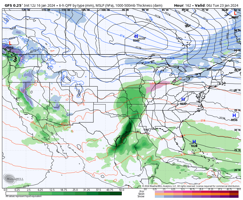
Though a moderating trend will kick in in full force next week, we’ll have to watch for the potential of a freezing rain and/ or sleet event Monday night into Tuesday (arctic air is always slower to erode than usually modeled) and a true shift to a wet pattern for the middle and latter part of next week.
Updated 01.09.24 @ 5:06p To say there’s a lot going on right now with this weather pattern is an understatement of understatements. When this involves an area such as central…
You must be logged in to view this content. Click Here to become a member of IndyWX.com for full access. Already a member of IndyWx.com All-Access? Log-in here.
Updated 01.09.24 @ 7:53a Burning the midnight oil and having plenty of coffee on hand is the only way to navigate this pattern over the course of the next week.…
You must be logged in to view this content. Click Here to become a member of IndyWX.com for full access. Already a member of IndyWx.com All-Access? Log-in here.