Updated 10.17.23 @ 5a
You must be logged in to view this content. Click Here to become a member of IndyWX.com for full access. Already a member of IndyWx.com All-Access? Log-in here.

Oct 17
Updated 10.17.23 @ 5a
You must be logged in to view this content. Click Here to become a member of IndyWX.com for full access. Already a member of IndyWx.com All-Access? Log-in here.
Permanent link to this article: https://indywx.com/video-new-seasonal-guidance-ups-the-ante-for-upcoming-winter-unsettled-close-to-the-work-week/
Oct 07
Updated 10.07.23 @ 6:09a

Though officially, we’re only a couple weeks into autumn, attention here has begun to shift towards the potential predominant pattern as we push into the holiday season.
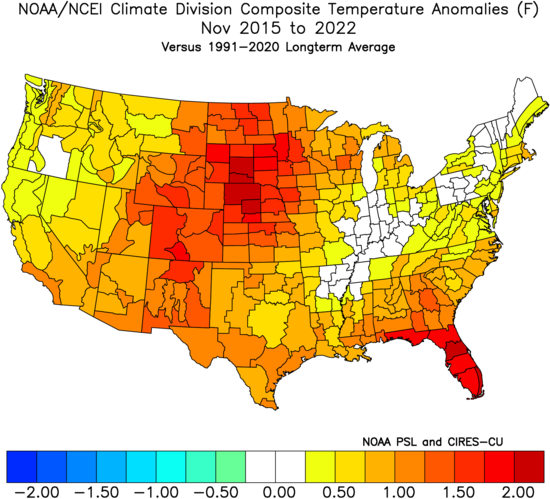
A quick, simple look back over the most recent November and December patterns is a sight that generates anxiety for most winter lovers. At a time when the majority of even non-winter lovers would like snow (i.e. the holidays), well above normal temperatures, and almost record warmth has become all too common over the years.
November 2015-2022
December 2015-2022
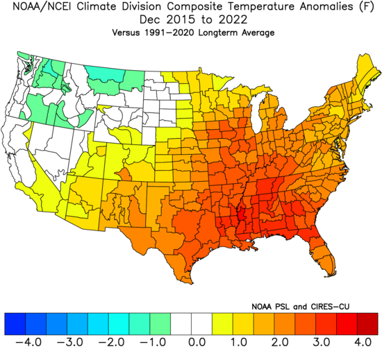
Is there reason to believe that could be different this year, especially with our base transition to El Nino? Simply put, not so fast my friend. El Nino winters are notorious for getting off to slower, warm starts. Our research shows that many times November can start cold but that the December pattern flips warmer around these parts. That’s, obviously, not to say it “has” to be that way. Many other factors contribute to the overall regime, but just that when you simply bundle all 1st year Nino events together, it’s more typical than not to find things play out such as illustrated above.
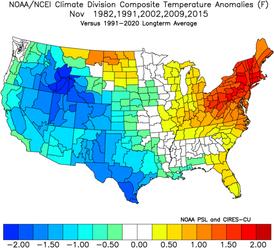
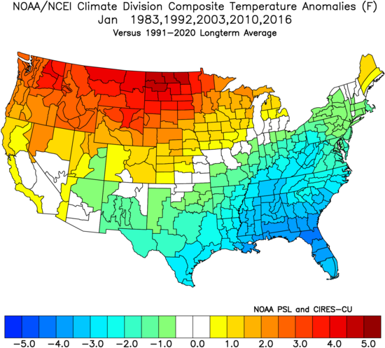
Let’s take a more specific look at our analog package (’82-’83, ’91-’92, ’02-’03, ’09-’10, and ’15-’16) and see what that suggests may be in store as we begin to set our eyes on the holidays.
November: Slightly above normal, locally. Unseasonably cold west and unseasonably warm New England are the headliners.
December: Greatest warm anomalies are centered over the Ohio Valley, in what otherwise is a large-scale warmer than normal regime from the Plains east.

January: The pattern begins to really flip around with cold bleeding southeast as the northern Plains and Northwest turn warmer than normal.
What does this all mean to me? While there’s only one that knows the future, if I was a betting man, I’d lean towards another holiday season that features above normal temperatures and most likely a greater than normal chance of below average December snowfall. I’d anticipate a few cold shots in November and the possibility of one or 2 accumulating snow events that gives way to the overall warmer idea in December. There’s always the chance the pattern begins to shift that last week of December for the colder January look… That’s the hope we’ll leave you with in this post in what otherwise will likely be a warmer than normal month as a whole.
Permanent link to this article: https://indywx.com/trend-hasnt-been-our-friend-as-of-late-around-the-holidays-reason-to-believe-this-year-is-different/
Sep 10
Updated 09.10.23 @ 10:46a
You must be logged in to view this content. Click Here to become a member of IndyWX.com for full access. Already a member of IndyWx.com All-Access? Log-in here.
Permanent link to this article: https://indywx.com/video-tuesday-frontal-passage-reviewing-new-seasonal-data-for-winter/
Sep 07
Updated 09.07.23 @ 7:15a
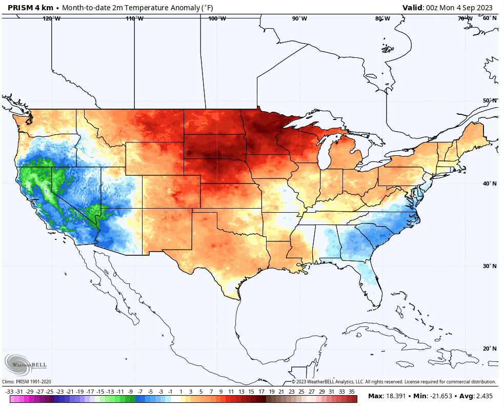
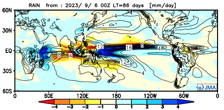
September has opened significantly warmer than normal across the northern Plains and to a lesser extent into the southern Plains and along the northern tier. Indianapolis is running 5° above average through the 6th. We’ll chip away some at those toasty anomalies over the course of the next week, but still anticipate the month finishing slightly warmer than normal as a whole. We’re also running dry- more than half an inch below normal to open the month.
As we look ahead to the upcoming couple of weeks, the combination of the Madden Julian Oscillation sneaking into Phase 4, combined with a strongly positive PNA should help lead to more of a trough across the eastern portion of the country.
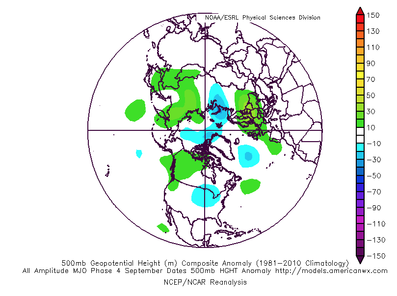

The NEW JMA Weeklies show that trough and associated cooler pattern (not cold by any means, but instead slightly below normal overall) taking up shop in the Week 1 and Week 2 time period below.


The latest ensemble guidance is also on board with the more seasonal look, especially compared to how the month opened.


Overall, the dry start to the month is anticipated to persist through the remainder of September as a whole.

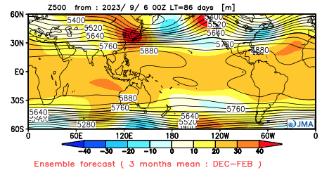
Jumping ahead, the JMA seasonal data also updated today. In short, the model shows a warm fall giving way to a warm start to the winter before potentially taking a colder mid and late winter turn. Still far too early to put much stock in the specifics from this distance. The next couple of months will be very telling with the migration (or lack thereof) of warmest central PAC sea surface temperatures along with modeled trends deeper into the winter. Long ways to go; stay tuned…
JMA meteorological (Dec. through Feb.) winter idea:

Permanent link to this article: https://indywx.com/long-range-chatter-new-jma-data-on-winter/
Sep 04
Updated 09.04.23 @ 8:58a
You must be logged in to view this content. Click Here to become a member of IndyWX.com for full access. Already a member of IndyWx.com All-Access? Log-in here.
Permanent link to this article: https://indywx.com/video-23-24-snow-nugget-rain-chances-return-tuesday-into-wednesday/