Updated 01.19.24 @ 7:35a
You must be logged in to view this content. Click Here to become a member of IndyWX.com for full access. Already a member of IndyWx.com All-Access? Log-in here.

Jan 19
Updated 01.19.24 @ 7:35a
You must be logged in to view this content. Click Here to become a member of IndyWX.com for full access. Already a member of IndyWx.com All-Access? Log-in here.
Permanent link to this article: https://indywx.com/long-range-update-pattern-evolution-through-the-remainder-of-winter-open-to-meteorological-spring/
Jan 01
Updated 01.01.24 @ 6:41p
I hope you and your family are enjoying an incredible New Year’s Day! What a game we have on our hands at halftime in the Rose Bowl.
I post this in flight back to home base from ushering in the new year in the beautiful Berkshire mountains. Our regularly scheduled client video discussions will return tomorrow morning. I trust you’ve been following along with both short and long term pattern ideas daily over the past week.
The immediate term opens with quiet and unseasonably calm conditions while the end of the upcoming 10-day stretch will end much colder. The transition between start and finish will turn much more hectic around these parts as we track not one, but two storm systems between this weekend and early next week. While there’s no doubt we’ll trend colder than average by Day 10, questions abound with just how cold we go. Should we get a snowpack down, subzero is on the table.
Speaking of the aforementioned more “hectic” pattern, this kicks into gear over the weekend. While modeling likes more of a suppressed track at this distance, thinking here is that guidance will start to pick up on a more organized northern piece of energy, or surface low reflection, that will accompany the primary Gulf low. I suspect a secondary, organized, shield of precipitation into the OHV region Friday night into Saturday. Will that be enough to put our neck of the woods into a winter storm risk during this timeframe? Too early to call at this distance, but given where the PNA, EPO, and Greenland Block that will be starting to mature, I’d recommend keeping an eye on what will likely be an eventual click or two northwest as the week goes along. It’s likely either a “snow or no” type situation here with storm #1, as opposed to having to worry about rain or mixing issues.
As for storm #2 early next week, our early idea takes the primary low into the OHV before a secondary low “takes over” along the eastern seaboard. The energy transfer likely brings just enough mild air north into the central Ohio Valley to create more of a rain to snow type scenario, locally. The coldest air of the season so far will likely follow in the 10-15 day.

Speaking of the 10-15 day, the look above is an absolute textbook upper air pattern not only for cold, but continued opportunities of winter weather here as we rumble into mid-January. By this point, other long term pattern drivers, such as the NAO and AO (of course to go along with the MJO, PNA, and EPO) will be factored in to where we head not only for the 2nd half of the month, but into late winter and spring. Recent trends certainly suggest the colder options are gaining traction. Today’s European Weekly update reflects a more persistent stretch of high latitude blocking I can remember o/ the past few winters. This ups the ante for a stormy stretch into and through the heart of winter. Given the longer term NAO and MJO look, I’d suspect the colder threat (relative to normal) is on the table into spring this year.
Much more in the AM! Make it a great evening!
Permanent link to this article: https://indywx.com/couple-thoughts-on-this-weekend-and-next-weeks-storms-colder-trends-build-long-term/
Dec 14
Updated 12.14.23 @ 7:22a
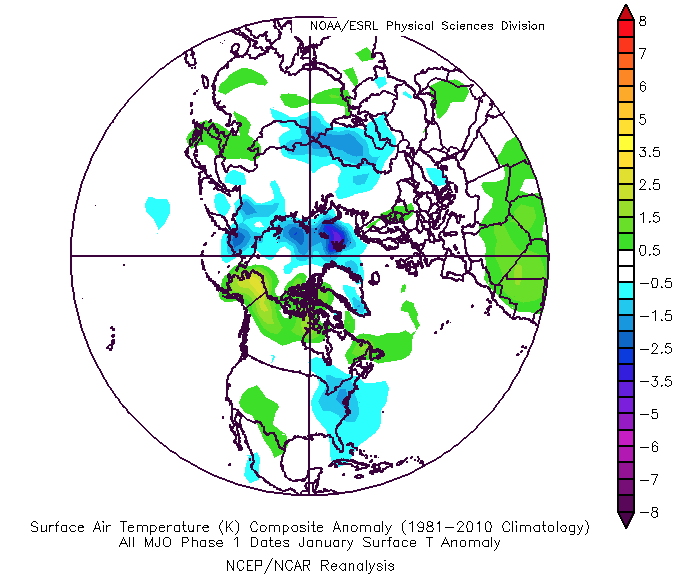
Right out of the gate, let’s look at the pattern drivers over the course of the next couple of weeks. By now, you know this starts with the MJO. One has to love the alignment of at least quickly moving out of the current warm phases and into the colder phases. By the 28th, both the GFS and European show us emerging into those colder phases.

The thought here is that we sneak into Phase 8 prior to month’s end and then roll into Phase 1 as we get into early January. The respective temperature composites are below.

That leads us to the PNA and EPO. (Remember, we’ll put more weight into the influence the NAO and AO can have on the regime after mid-January).
The PNA, or Pacific North American pattern, remains in a favorable state for eastern cold.


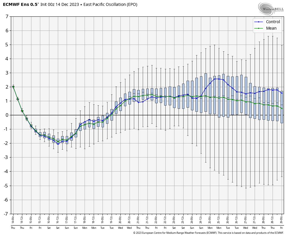
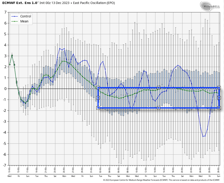
However, the EPO doesn’t want to play nice and will put pressure on any sort of sustained, meaningful cold getting involved over the next 10 days- that is until the MJO gets into the cold phases.
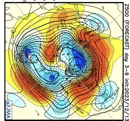
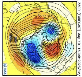
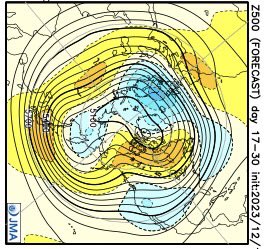
The JMA Weeklies show the progression of the upper pattern best, in my opinion, from any of the long range data that’s currently available for the late December-1st half of January timeframe.
We’ve had several new subscribers of IndyWx.com All-Access over the past couple of weeks so I wanted to take time to drop a direct link to our annual Winter Outlook. As we get set to put a bow on the first month of meteorological winter, there’s no change to our ongoing idea of the winter as a whole here.
I originally thought the shift to a colder pattern would take shape around 12/20 (give or take a couple of days). While that idea appears to be too aggressive, there’s certainly no backing away from the colder pattern progression as a whole, at least from my perspective. The expectation is that we do, indeed, get into the colder phases of the MJO and that sets off the larger global signal that will likely shift the EPO into a colder phase. It’s interesting that the European Weeklies show this exact thing taking shape down the road (once past 1/1).
While we’re not of the thought this evolves into anything frigid (some sort of overwhelming arctic air mass, for example), we do want to double down on the idea of a slightly colder than normal regime taking hold as we get into the new year. The thought here is that this slightly colder than normal pattern will also have staying power through a good chunk of January, given where I believe the MJO will spend the majority of time. What’s also of interest is the energized southern stream beginning to show itself (going to be one heck of a storm roaring out of the Gulf this weekend). I’d imagine we’re only just beginning to see the active pattern take hold and it won’t take much to get a storm or two to try and phase with northern stream energy if we see the evolution take hold that I envision down the road. At the very least, it’s certainly not a boring pattern.
We’ll have more detailed thoughts on the weekend and next week’s pattern in our updated Client video that will be posted a bit later today!
Permanent link to this article: https://indywx.com/the-trend-is-your-friend-long-range-discussion-into-mid-january/
Dec 08
Updated 12.08.23 @ 7:22a
As we hone in on the late December and early January pattern, there remains little if any change in the thought here that a more widespread cold pattern will evolve across the eastern 1/3 of the country. We note the Madden Julian Oscillation (MJO) is still showing that it wants to progress out of the traditionally warm December phases we’re in now into the colder phases post 12/20.

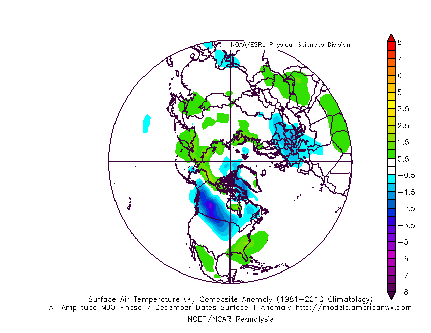
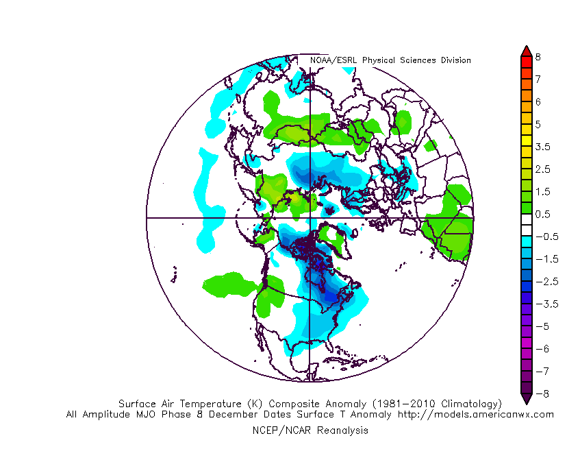
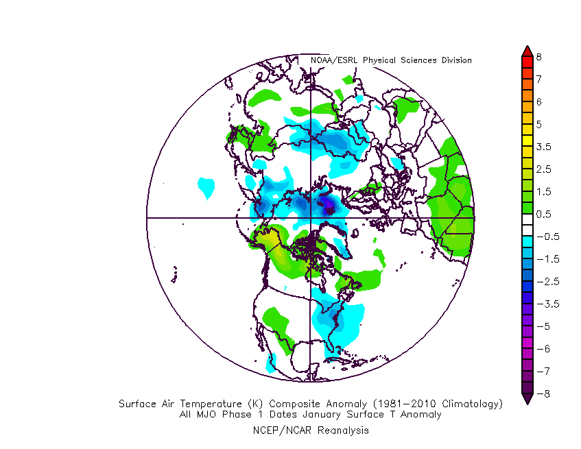
While we fully anticipate a more sustained colder than normal pattern to evolve in the 12/20 to 1/10 timeframe, I think this should be more of a situation that’s slightly colder than normal versus some sort of major arctic blast. All the same, as we get into the time of year when averages are close to their lowest, that will speak volumes given where we’ve been up to that point through the majority of December.
From a precipitation standpoint, these respective phases usually produce below normal precipitation across our neck of the woods, at least until we get into Phase 1 in January (interesting with the expected colder regime in place by that time period, heh?).
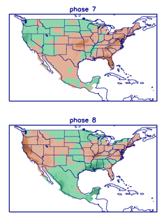
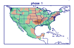
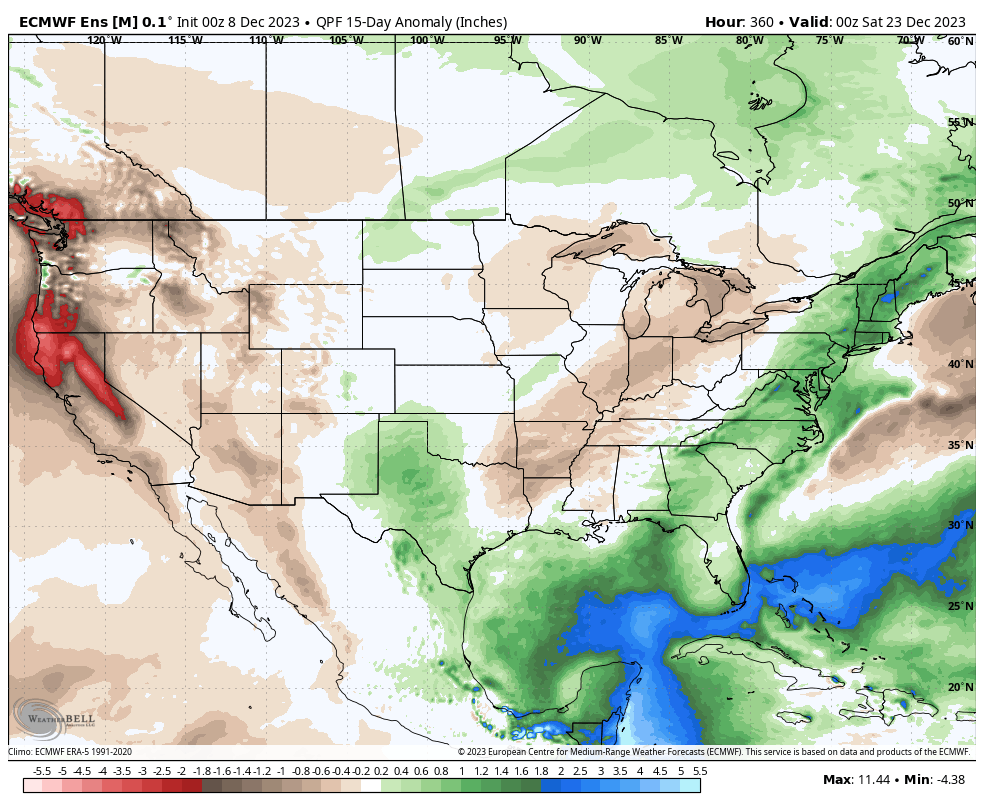
When we go look at the latest European ensemble precipitation anomalies over the next couple weeks (ending Dec. 22nd), the dry theme is alive and kicking. Frankly, it a very El Nino-like look (drier here while wetter across the Southeast and eastern seaboard) and shouldn’t come as a surprise.
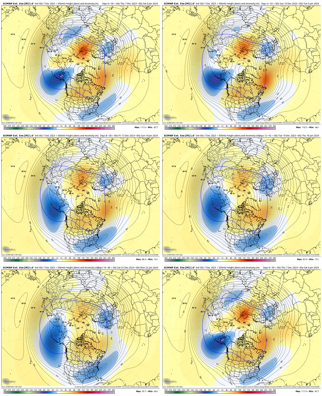
Also of interest is the way the longer range weekly modeling shows the trough becoming more prevalent and sustained out in that post December 20th timeframe, continuing into early January.
European Weeklies: Winter wx fans also have to like all of the high latitude blocking on this run while the trough expands and sustains itself. Immediate take-away from yesterday’s run? Chilly and stormy close to the year and open to ’24.
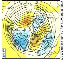
JMA Weeklies: In similar fashion to the Euro, the model really expands and deepens the eastern trough Weeks 3-4. Again, it’s a chilly and stormy look.
In closing, we see no reason to deviate from our long standing idea of a pattern shift to chillier than normal around Christmas that should carry us into the first couple weeks of January. By that point, we’ll have to start monitoring other teleconnections (along with the MJO, of course), such as the NAO, to gain more clarity on the regime as we push into the 2nd half of meteorological winter.
Permanent link to this article: https://indywx.com/lr-discussion-to-close-the-year-and-head-into-the-1st-half-of-january/
Dec 07
Updated 12.07.23 @ 7:53a Long winded discussion this morning diving into the long range pattern evolution through the holidays, including drivers behind the transition we believe is ahead. We also…
You must be logged in to view this content. Click Here to become a member of IndyWX.com for full access. Already a member of IndyWx.com All-Access? Log-in here.
Permanent link to this article: https://indywx.com/video-a-lot-to-discuss-this-morning-between-the-short-term-and-long-range-pattern-evolution/