Category: Winter Storm

Next Winter Storm Moves In Sunday Afternoon…

Screen Shot 2015-01-10 at 8.41.13 AM

Highlights:

  • Dangerous Cold Continues This Morning
  • Winter Storm Arrives Sunday Afternoon
  • Another Push Of Below Zero Air Mid Week
  • Watching Thursday

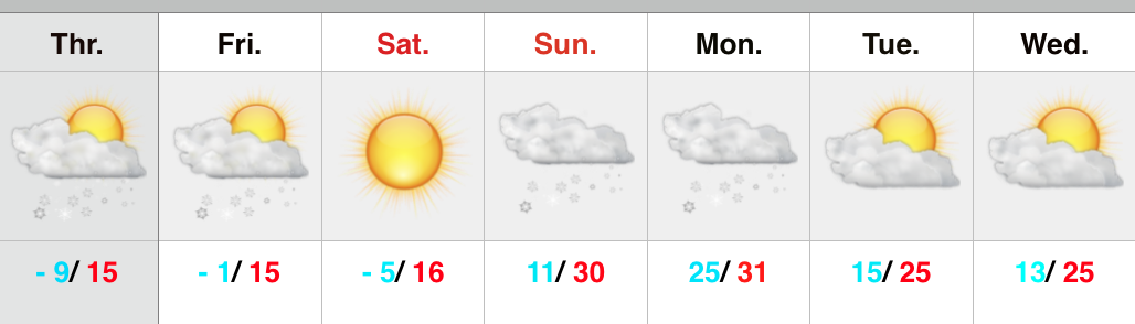
Sunny Today; Next Winter Storm Arrives Tomorrow…While it’s always nice to see the sun, it won’t do much to warm temperatures this afternoon.  Another frigid morning (all reporting sites across central Indiana went below zero again this morning) will only “warm” into the upper teens this afternoon.

The big focus of this forecast package has to do with what lies ahead Sunday afternoon through Monday morning.  Model data continues to suggest central Indiana deals with another winter storm.  A model average puts down between 0.30″ to 0.50″ (liquid equivalent).  On a standard 10:1 ratio, that would be between 3-5″ of snow, and if that 0.30″-0.50″ all fell in the form of freezing rain we would be looking at a damaging ice storm.  As of now it appears as if we deal with the entire wintry precipitation gamut.

Moisture will surge north Sunday afternoon and we bracket the hours between 3-5p for the onset of wintry precipitation.  Low pressure will organize along the Gulf Coast and move northeast into the Tennessee Valley Monday morning.  At the same time, another dome of arctic high pressure will begin to sink south.  The end result should be a wintry mix of sleet and freezing rain that eventually transitions to snow through the nighttime Sunday.  Obviously timing that transition will be crucial in determining just how much snow and ice accumulates.  As of now we’ll split the expected liquid equivalent down the middle and say 0.40″ falls across central Indiana.  Of that 0.40″, 0.20″ may fall as freezing rain (glaze) and 0.20″ may fall as snow (which would stack up to a couple inches on the standard 10:1 ratio).  Areas north of Indianapolis run a better chance of seeing the transition to snow faster while areas south of the city run a higher chance at accumulating more freezing rain.  Stay tuned.

We go back into the deep freeze Tuesday-Wednesday and eye Thursday for the possibility of another storm system.

Upcoming 7-Day Precipitation Forecast:

  • 7-Day Snowfall Forecast: 1″ – 3″
  • 7-Day Freezing Rainfall Forecast: 0.20″ 

Permanent link to this article: https://indywx.com/next-winter-storm-moves-in-sunday-afternoon/

Wintry Sandwich Sunday Evening-Monday; More Bitter Cold Follows.

Busy times continue in the good ole weather office as we get set to deal with yet another winter storm during the upcoming weekend.

First, we’ll deal with more below zero temperatures tonight and Saturday morning as overnight lows bottom out between 5 and 10 degrees below zero tonight area-wide.  Wind chill values, of course, will be even colder (-15 to -25).  Dangerous cold continues with considerable blowing and drifting in the open country.  Saturday will be the “calm before the storm” with unseasonably cold conditions continuing, but with lighter winds and sunshine.

Clouds will increase Saturday night into Sunday and we’ll begin to introduce precipitation into your forecast as early as Sunday afternoon (not a bad day for two classic back-to-back playoff games if you ask me).  Here’s our best idea of what you can expect statewide after reviewing all guidance today:

011115event


Some initial thinking would place the following numbers (a bit early to be too specific), and we caution this will have to be fine tuned as we move forward.

Snow accumulation of 2″-4″ across north-central Indiana, particularly just north of Indianapolis.  In the “mainly snow” zone, expect amounts of 3″-6″.  Ice storm criteria accumulation of freezing rain is possible (0.25″, or greater) across central Indiana, as well.  South of the city, early ideas suggest roughly 1″-2″ of snow and glaze potential closer to that potentially damaging 0.25″ amount.  Again, we state that these numbers are very early ideas and will have to be fine tuned.

Precipitation should initially overspread central Indiana Sunday afternoon in the form of sleet and snow (more sleet south-central, more snow north-central) before transitioning to more of a sleet and freezing rain event.  Finally, we anticipate the wintry mixture of precipitation to end as snow before moving out Monday morning.  Timing and duration of precipitation types will obviously determine how much ice and snow a given location sees.

Another big item we want to be sure to mention is that yet ANOTHER push of bitter arctic air will invade behind this storm and set the stage for another dangerously cold period Tuesday into Wednesday (back below zero we go)!

Stay tuned as we continue to fine tune the forecast over the weekend!

Permanent link to this article: https://indywx.com/wintry-sandwich-sunday-evening-monday/

Catching Up On Where We’ve Been And What Lies Ahead…

January is off to a frigid start. After a mild December, January is certainly reminding folks that there’s a lot of winter in this pattern. Precipitation is running above normal…

You must be logged in to view this content. Click Here to become a member of IndyWX.com for full access.  Already a member of IndyWx.com All-Access?  Log-in here.

Permanent link to this article: https://indywx.com/catching-up-on-where-weve-been-and-what-lies-ahead/

Fresh Arctic Air Inbound; Winter Storm Potential Sunday Night-Monday.

Tonight’s video update discusses the heavier burst of snow inbound, fresh arctic air/ dangerous wind chill values Friday, and takes a look at more “wintry mischief” brewing for late in…

You must be logged in to view this content. Click Here to become a member of IndyWX.com for full access.  Already a member of IndyWx.com All-Access?  Log-in here.

Permanent link to this article: https://indywx.com/fresh-arctic-air-inbound-winter-storm-potential-sunday-night-monday/

Wind And Snow Arrives This Evening; Fresh Arctic Air Invades…

Screen Shot 2015-01-08 at 7.19.42 AM


Ready For More Wind And Snow?!  The day will dawn with sunshine and downright frigid temperatures.  Some numbers as of 7am include the following:

  • Zionsville: – 10
  • Eagle Creek: – 6
  • Indianapolis: – 6
  • Frankfort: – 10
  • Kokomo: – 8

Wind chill readings are obviously even colder (- 20 to -30).  Clouds will quickly increase as we progress into the afternoon hours and snow won’t be far behind.  We forecast a quick burst of heavier snow between 5-7p followed by snow showers through the evening.  Most folks from Indianapolis and points north will accumulate around an inch of new snow this evening.  Winds will also be very gusty and lead to all sorts of blowing and drifting concerns once again (of new snow and existing snow).

Temperatures will fall Friday and be in the single digits for most of the day before heading back below zero Friday evening/ Saturday morning.  Welcome to the frozen tundra! 🙂

Our next winter event of significance will press in Sunday.  Clouds will lower and thicken through the day and snow should develop by evening.  Light snow and potentially a wintry mix will continue Sunday night into the day Monday.  Stay tuned!

Upcoming 7-Day Precipitation Forecast:

  • 7-Day Snowfall Forecast: 2″ – 4″
  • 7-Day Rainfall Forecast: 0.00″

Permanent link to this article: https://indywx.com/wind-and-snow-arrives-this-evening-fresh-arctic-air-invades/