Category: Winter Storm
Overnight model data remains very much out of agreement with one another concerning Sunday. The struggle continues trying to figure out the precise track of the low and the influence…
You must be logged in to view this content. Click Here to become a member of IndyWX.com for full access. Already a member of IndyWx.com All-Access? Log-in here.
Permanent link to this article: https://indywx.com/saturday-morning-rambles-4/
 Weekend Snow Storm On Deck…Scattered snow flurries and snow showers will come to an end this morning with increasing sunshine following. Despite seeing a little vitamin D this afternoon, it won’t do anything to help us in the temperature department. In fact, we already experienced our high around midnight. Temperatures this afternoon will remain in the middle to upper 20s with a gusty wind.
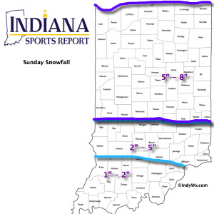
Most of Saturday will be quiet (calm before the storm) with dry conditions and afternoon highs around 40. Clouds will lower and thicken as we go through the afternoon and evening and snow will develop (rain or a wintry mix down state initially) across central Indiana during the overnight. Snow will increase in intensity Sunday morning and grow heavy at times during the day as low pressure tracks along the Ohio River (a classic track for central Indiana snow storms). See our initial accumulation map below, which is still subject to change. We’ll introduce a gusty east and northeast wind into the mix Sunday evening and night and this will lead to blowing and drifting snow Sunday night. Stay tuned.
The big story next week will be the cold, but we’re also watching two potential snow makers, as well. More on that after we deal with Sunday’s snow storm.
Upcoming 7-Day Precipitation Forecast:
- 7-Day Snowfall Forecast: 5″ – 10″
- 7-Day Rainfall Forecast: Trace

Permanent link to this article: https://indywx.com/weekend-snow-storm/
Early forecast model data into the office tonight suggests we remain on track for a disruptive widespread snow storm this weekend. We note the timing is speeding up just a…
You must be logged in to view this content. Click Here to become a member of IndyWX.com for full access. Already a member of IndyWx.com All-Access? Log-in here.
Permanent link to this article: https://indywx.com/late-night-update-snow-storm-brewing/
First, enough energy needed out of the SW is going to come out and lead to a widespread snow storm from the central Plains through the Ohio Valley. Here on the…
You must be logged in to view this content. Click Here to become a member of IndyWX.com for full access. Already a member of IndyWx.com All-Access? Log-in here.
Permanent link to this article: https://indywx.com/weekend-snow-storm-on-deck-and-a-word-on-february/
Forecast models for the most part have been much more aligned with this upcoming event, with the exception of a couple runs on Wednesday. Overnight and this morning modeling is…
You must be logged in to view this content. Click Here to become a member of IndyWX.com for full access. Already a member of IndyWx.com All-Access? Log-in here.
Permanent link to this article: https://indywx.com/weekend-snow-storm-brewing/


