Category: Winter Storm

Multiple Snow Makers; Cold Grows More Bitter…

Updated 02.08.21 @ 8:32a

Most of the daytime today will only feature light snow, but don’t let that fool you. With such a cold, arctic airmass in place, even the “light” snow is creating travel issues in spots. Take it slow out there, friends.

A new piece of upper level energy will streak across the region tonight and help snow to become more organized in aerial coverage. A narrow, but efficient band of steadier snow is expected to get going across south-central Indiana around, or just after, sunset. It’s within this snow where we expect several inches of snow to accumulate tonight and early Tuesday morning.

Snow will become moderate to heavy at times across south-central IN tonight.

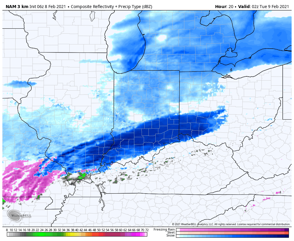
Most of the steady snow will exit to the east before sunrise Tuesday. We’ll then be left with periods of flurries and light snow through the remainder of the day.

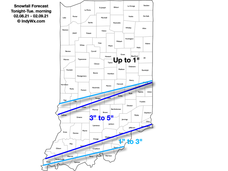
Here’s our snowfall forecast with tonight’s system:

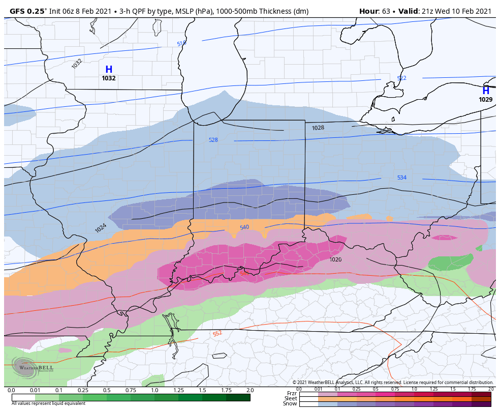
Attention will then shift to a “juicier” midweek storm system. An arctic boundary will remain draped to our south while a surface wave rides northeast along the stalled front. This will allow more widespread, heavier precipitation to push into the region (from southwest to northeast) through the morning Wednesday. For a time, moderate to heavy precipitation rates are expected Wednesday evening into Wednesday night. The early call on this system continues to be for an all snow event across central Indiana (where we think 3″ to 6″ of fresh snow is a good bet) with more of a wintry mix of snow, sleet, and freezing rain across southern portions of the state as warmer air aloft gets pulled north. Unfortunately, I think even southern portions of the state remain cold at the surface, continuing the threat of an icy glaze vs. a plain ole rain.

Widespread wintry precipitation will overspread the region Wednesday.

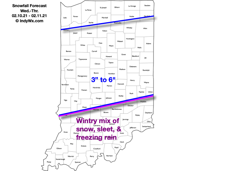
Here’s our snowfall forecast for Wednesday and Thursday:

As the snow continues to add up, concern will mount around the issues that will likely come from a blowing and drifting perspective- especially as a fresh arctic intrusion arrives late week. If that wasn’t enough, additional “fun and games” are on the table for the upcoming weekend, followed by the coldest air so far this season (and in some cases in a couple of years).

Stay tuned…

Permanent link to this article: https://indywx.com/multiple-snow-makers-cold-grows-more-bitter/

VIDEO: Snowpack Expands In The Week Ahead…

Updated 02.07.21 @ 9:02p

You must be logged in to view this content. Click Here to become a member of IndyWX.com for full access.  Already a member of IndyWx.com All-Access?  Log-in here.

Permanent link to this article: https://indywx.com/video-snowpack-expands-in-the-week-ahead/

VIDEO: Rain/ Mix Changes Back To Snow; Looking At A Busy Couple Weeks Ahead…

Updated 01.31.21 @ 11:00a

You must be logged in to view this content. Click Here to become a member of IndyWX.com for full access.  Already a member of IndyWx.com All-Access?  Log-in here.

Permanent link to this article: https://indywx.com/video-rain-mix-changes-back-to-snow-looking-at-a-busy-couple-weeks-ahead/

VIDEO: Heavy Snow Builds In This Evening; Active, Wintry Pattern Remains Intact To Open February…

Updated 01.30.21 @ 3:06p

You must be logged in to view this content. Click Here to become a member of IndyWX.com for full access.  Already a member of IndyWx.com All-Access?  Log-in here.

Permanent link to this article: https://indywx.com/video-heavy-snow-builds-in-this-evening-active-wintry-pattern-remains-intact-to-open-february/

Client Brief: Heavy Snow Hit On Deck For The Northern Half Of Indiana…

Updated 01.30.21 @ 7:28a


Type: Impactful Wintry Weather

What: Accumulating snow

When: 4p Saturday – 4a Sunday

Temperatures: 29° to 33°

Wind: SE 10 – 20 MPH and gusty

Blowing/ Drifting: Minimal 

Pavement Impacts: Plowing and salting will be required

Summary: Clouds will continue to lower and thicken through the morning. By early afternoon, the sky across most of central IN will have that classic look of a snowstorm brewing, and rightfully so. The initial band of snow will arrive mid to late afternoon (we bracket 4p to 5p into Indianapolis, itself). The combination of evaporative cooling, strong lift, and embedded banding features will likely result in S+ (heavy snow) throughout the evening hours across central Indiana. This will be a wet, heavy snow. As the heavy precipitation begins, the column of air will cool rapidly late afternoon (temperatures will likely fall from around 40° into the lower 30s within less than an hr as part of the “evaporative cooling” process). Looking over the latest guidance, it continues to appear as if areas along and south of the I-70 corridor will then go just above freezing later tonight and result in a brief mix before transitioning over to rain. Drizzle or mixed rain and snow showers Sunday will transition back to snow showers throughout the afternoon, but the majority of accumulating snow across our region will fall in that 12 hour period from 4p Saturday to 4a Sunday. 

Confidence: High

Next Update: This afternoon (video)

Permanent link to this article: https://indywx.com/client-brief-heavy-snow-hit-on-deck-for-the-northern-half-of-indiana/