Category: Windy

Wet Thursday; Major Improvements In Time For Halloween; Jab Of Early Season Arctic Air To Open Next Week…

Rain is falling across all of central and southern portions of the state this morning, but there’s a sharp cut-off across northern Indiana, thanks to a frontal boundary. It’s a “what you see is what you get” kind of day as steady rain will continue into the afternoon before becoming more showery in nature. Additional rainfall amounts will range from between 0.25″ and 0.75″.
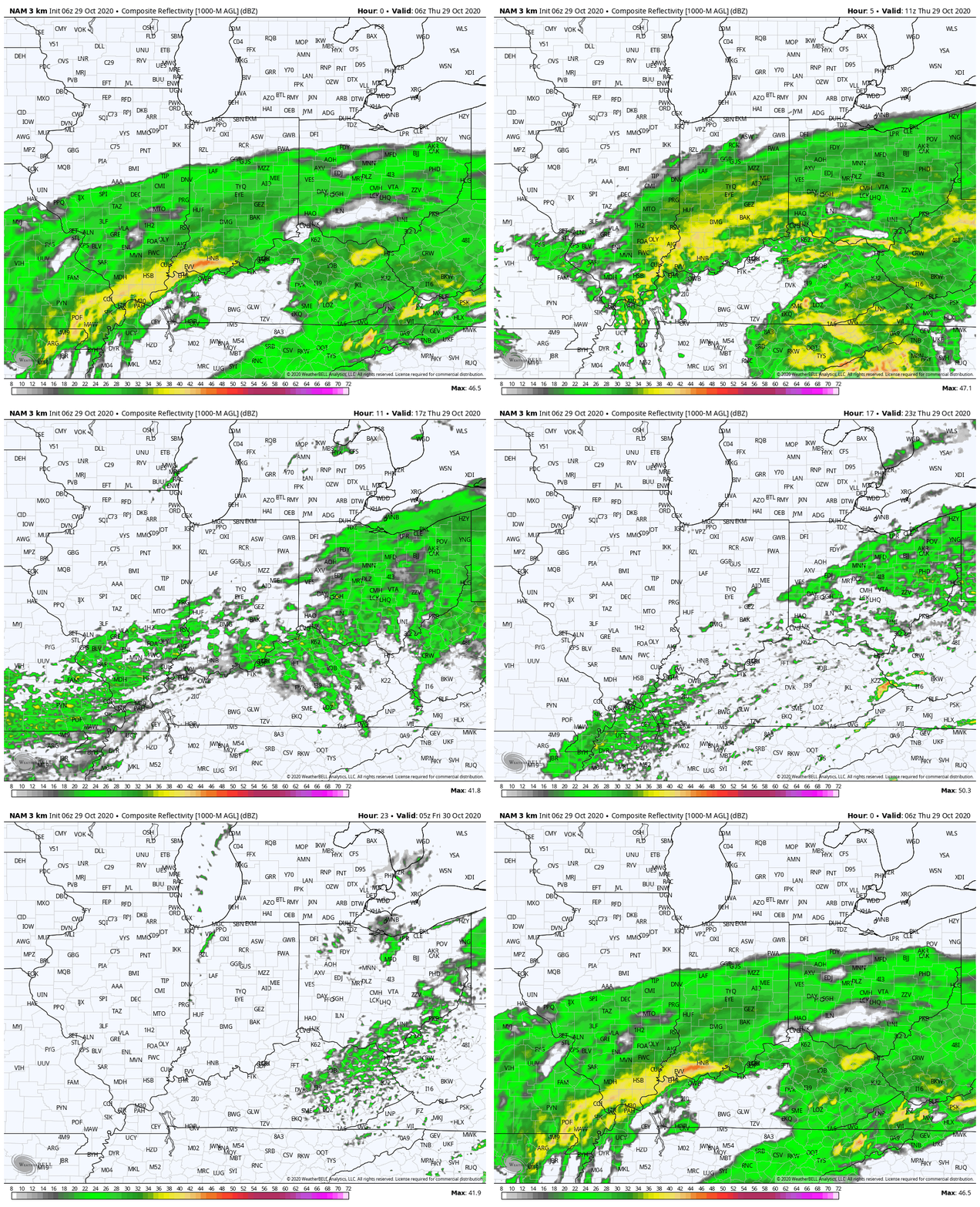
Rain will exit the state off to the southeast by 9p-10p this evening, but by that time there could be a few lake effect rain showers flowing off Lake Michigan and impacting far northwest IN as cooler air pours into the region.

Speaking of that, lows tonight and Friday morning will fall into the middle 30s for most of central IN.
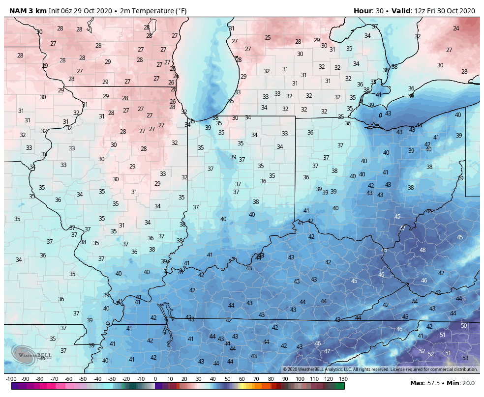
High pressure will build into the region as we wrap up the week and help supply a return of dry, sunny weather Friday and Halloween, itself.

Our quiet weather will give way to blustery and colder conditions to close the weekend and open up the new work week as the arctic comes visiting for the first time this season.
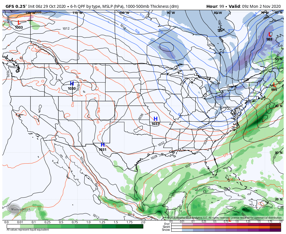
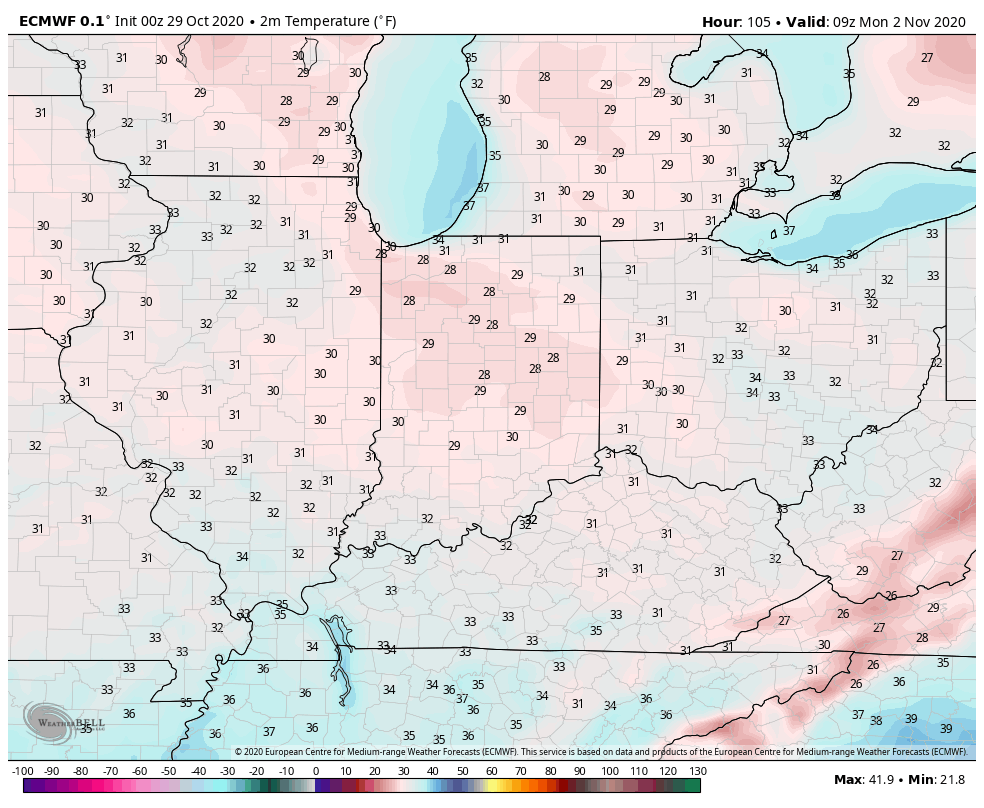
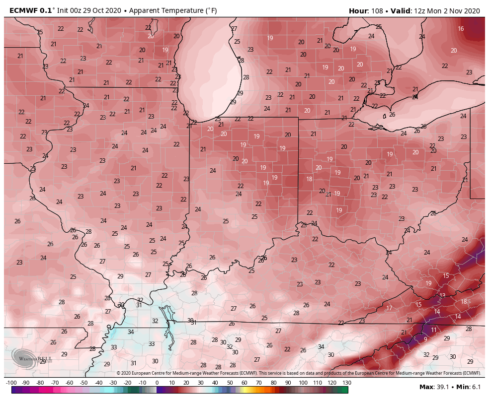
This is the type system that will generate the first lake effect snow event of the season for the eastern Great Lakes Snow Belt communities. We can expect a hard freeze Monday morning with temperatures falling into the upper 20s and wind chill values into the 10s.
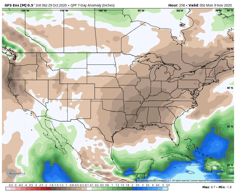
As next week matures, temperatures will begin to moderate and high pressure will supply an extended period of dry conditions. Overall, we’re looking at a much quieter week ahead compared to the past couple of weeks.
Permanent link to this article: https://indywx.com/2020/10/29/wet-thursday-major-improvements-in-time-for-halloween-jab-of-early-season-arctic-air-to-open-next-week/

VIDEO: Wind-Driven Rain Event Overspreads The Region Overnight; Sharp Jab Of Early Season Arctic Air To Open The New Week…

You must be logged in to view this content. Click Here to become a member of IndyWX.com for full access.  Already a member of IndyWx.com All-Access?  Log-in here.

Permanent link to this article: https://indywx.com/2020/10/28/video-wind-driven-rain-event-overspreads-the-region-overnight-sharp-jab-of-early-season-arctic-air-to-open-the-new-week/

VIDEO: Heavy Rain Builds In Wednesday Night; Jab Of Early Season Arctic Air Sunday-Monday…

You must be logged in to view this content. Click Here to become a member of IndyWX.com for full access.  Already a member of IndyWx.com All-Access?  Log-in here.

Permanent link to this article: https://indywx.com/2020/10/27/video-heavy-rain-builds-in-wednesday-night-jab-of-early-season-arctic-air-sunday-monday/

VIDEO: Sharply Colder Air Flows Into The Region To Close The Week; A Look At How The EPO Impacts Our Weather…

You must be logged in to view this content. Click Here to become a member of IndyWX.com for full access.  Already a member of IndyWx.com All-Access?  Log-in here.

Permanent link to this article: https://indywx.com/2020/10/14/video-sharply-colder-air-flows-into-the-region-to-close-the-week-a-look-at-how-the-epo-impacts-our-weather/

VIDEO: Getting To Be That Time Of Year- Pattern Turns Busier To Close October…

You must be logged in to view this content. Click Here to become a member of IndyWX.com for full access.  Already a member of IndyWx.com All-Access?  Log-in here.

Permanent link to this article: https://indywx.com/2020/10/12/video-getting-to-be-that-time-of-year-pattern-turns-busier-to-close-october/

And Then The Autumn Breeze Kicked In…

Yesterday’s 0.08″ of rain at IND was the “heaviest” for the month, but still well shy of modeled output. There were a few heavier totals across southern portions of the state. Even though this wasn’t supposed to be a heavy rain maker, I thought we’d see higher totals than we did. The dry ground really took its’ toll on the moisture as it moved across the state (interesting to see the rain shield intensify yet again just east of us across Ohio).

Today will be a gorgeous fall day- expect a clear and chilly start to give way to a few afternoon clouds and highs in the lower 60s.

A secondary cold front will sweep through the region tomorrow evening, helping serve up even chillier conditions as we get set to close the week. A few showers (light in nature) can be expected for the 2nd half of the work week, mostly thanks to upper level energy. The other item to note? West breezes kicking up to 25 MPH tomorrow afternoon.

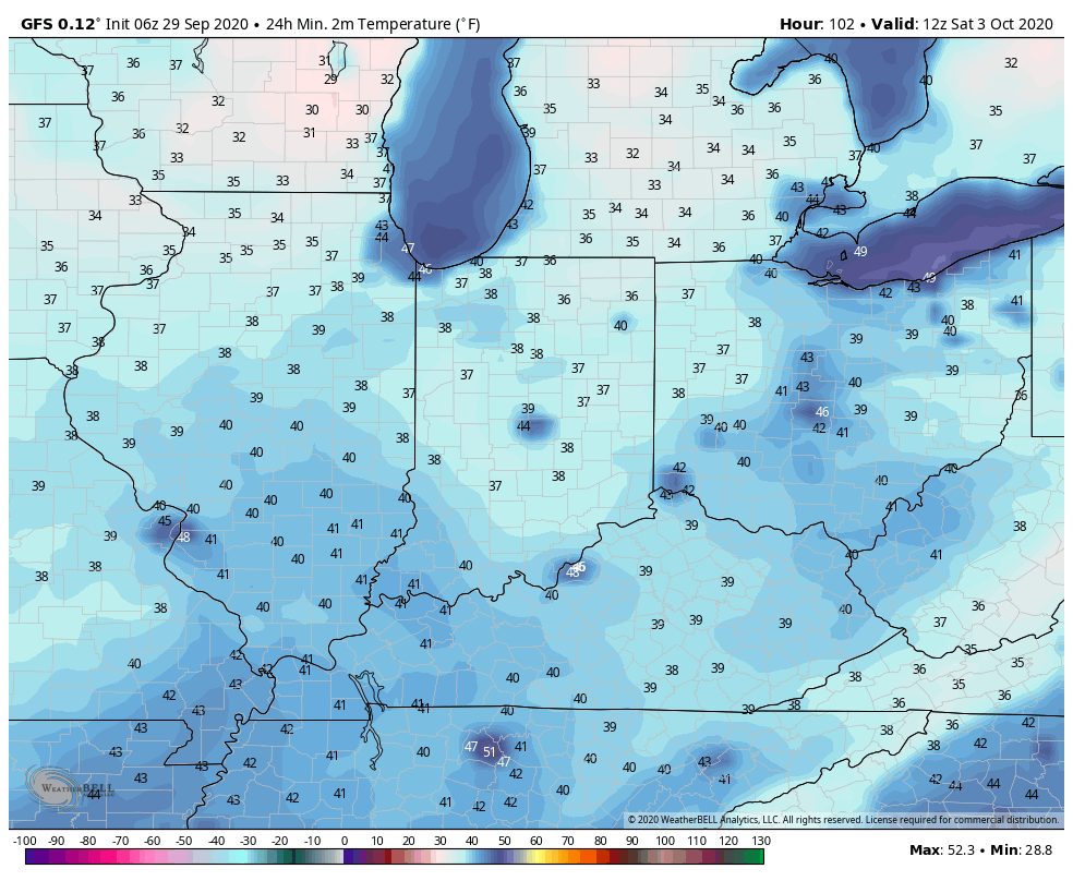
We should hang on to just enough overnight cloud cover to prevent any frost formation across central Indiana until Friday night/ Saturday morning. Skies are expected to clear and winds should diminish to allow the coolest air of this particular airmass to settle over the region. Mid 30s will be common across central Indiana by Saturday morning. The combination of the early chill and dryness certainly will activate the fall color change much earlier this year compared to normal. In fact, I’d expect an early to middle October peak this year.

The next feature will scoot across the Ohio Valley Sunday with an increase in cloud cover and potential of showers. We note the European’s output is close to 0.50″ with this system, but we won’t bite on that. Instead, we forecast between 0.20″ and 0.30″ Sunday. It’ll also be an unseasonably cool day with highs only topping out in the middle 50s.

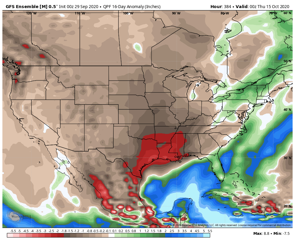
Let’s hope we can squeeze what little moisture we can out of Sunday’s weather maker because the pattern looks very dry over the next couple weeks, as a whole, and likely beyond. The only way we can buck this dry trend between now and late November is to get some tropical moisture injected in the pattern up this way. I wouldn’t hold my breath…

More later today in our video update! Enjoy your Tuesday!

Permanent link to this article: https://indywx.com/2020/09/29/and-then-the-autumn-breeze-kicked-in/

VIDEO: Damaging Wind Event Set To Impact Portions Of The State This Evening…

You must be logged in to view this content. Click Here to become a member of IndyWX.com for full access.  Already a member of IndyWx.com All-Access?  Log-in here.

Permanent link to this article: https://indywx.com/2020/08/10/video-damaging-wind-event-impacts-portions-of-the-state-this-evening/

VIDEO: Gusty Storms Impact Parts Of The Area Tonight; Pattern Turns Active To Close July…

You must be logged in to view this content. Click Here to become a member of IndyWX.com for full access.  Already a member of IndyWx.com All-Access?  Log-in here.

Permanent link to this article: https://indywx.com/2020/07/11/video-gusty-storms-impact-parts-of-the-area-tonight-pattern-turns-active-to-close-july/

VIDEO: One More Tropical-Like Day With Storms Before A Blast Of Drier, Cooler Air…

You must be logged in to view this content. Click Here to become a member of IndyWX.com for full access.  Already a member of IndyWx.com All-Access?  Log-in here.

Permanent link to this article: https://indywx.com/2020/06/10/video-one-more-tropical-like-day-with-storms-before-a-blast-of-drier-cooler-air/

VIDEO: Short-Term Wintry Opportunities And Longer Range MJO Chatter…

Updated client video to go along with this morning’s discussion…

You must be logged in to view this content. Click Here to become a member of IndyWX.com for full access.  Already a member of IndyWx.com All-Access?  Log-in here.

Permanent link to this article: https://indywx.com/2020/04/13/video-short-term-wintry-opportunities-and-longer-range-mjo-chatter/

IndyWx.com