Updated 10.13.21 @ 7:30a
You must be logged in to view this content. Click Here to become a member of IndyWX.com for full access. Already a member of IndyWx.com All-Access? Log-in here.

Oct 13
Updated 10.13.21 @ 7:30a
You must be logged in to view this content. Click Here to become a member of IndyWX.com for full access. Already a member of IndyWx.com All-Access? Log-in here.
Permanent link to this article: https://indywx.com/2021/10/13/video-heavier-rain-arrives-friday-more-seasonal-weekend-ahead/
Oct 09
Updated 10.09.21 @ 9:30a
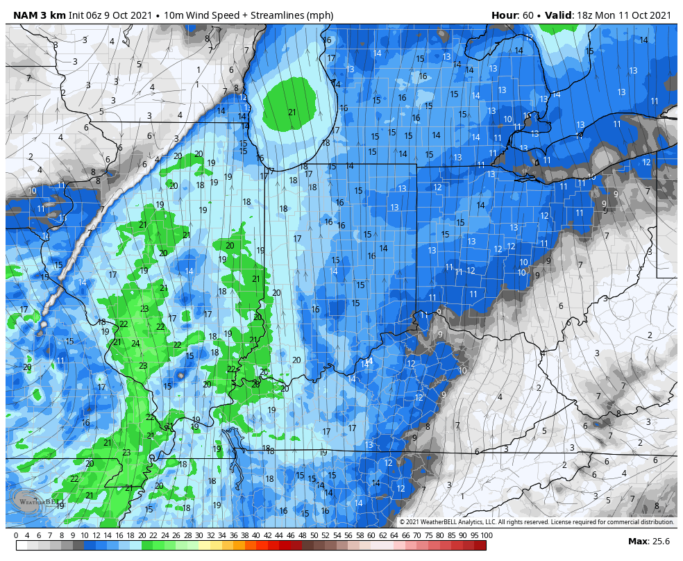
After a mostly dry, sunny, and unseasonably warm weekend, our next storm system will approach as we kick off the work week. Southerly winds will usher in an unseasonably moist airmass to combine with August-like temperatures (highs once again are expected to shoot into the lower and middle 80s).

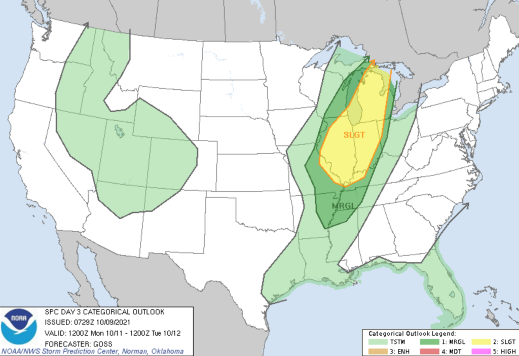
The Storm Prediction Center (SPC) outlines the western Ohio Valley, including most of Indiana, into the central Great Lakes region for a Slight Risk of severe weather Monday.
A surface wave is expected to develop along the pressing cold front Sunday evening and track northeast into the Great Lakes. After a warm, dry, and breezy start to Monday, a line of thunderstorms should develop late Monday morning or early afternoon across western IL. This line will then track east and move into Indiana during the late afternoon and evening hours.
Given some of the ingredients in place, the primary concern with this line of storms will be the potential of damaging straight line winds. There also is the potential of a couple rotating storms within this overall line of storms that could pose an isolated tornado threat.
After the stormy time of things Monday PM (rainfall amounts should check-in between 0.50″ and 1″ for most), conditions will improve as we move through the day Tuesday. Another (weaker) system will push into the area midweek, but as of now this doesn’t look like a significant event.
A stronger cold front will arrive to close the week with more widespread rain. After an unseasonably warm stretch, cooler air should finally filter into the region next weekend.
Permanent link to this article: https://indywx.com/2021/10/09/monitoring-mondays-storm-threat/
Sep 22
Updated 09.22.21 @ 7:34a
You must be logged in to view this content. Click Here to become a member of IndyWX.com for full access. Already a member of IndyWx.com All-Access? Log-in here.
Permanent link to this article: https://indywx.com/2021/09/22/video-chilly-with-a-wind-whipped-rain-sunshine-returns-friday/
Sep 21
Updated 09.21.21 @ 7:30a
You must be logged in to view this content. Click Here to become a member of IndyWX.com for full access. Already a member of IndyWx.com All-Access? Log-in here.
Permanent link to this article: https://indywx.com/2021/09/21/video-more-of-a-november-like-feel-turning-wet-raw-and-windy-for-midweek/
Sep 17
Updated 09.17.21 @ 7:50a
You must be logged in to view this content. Click Here to become a member of IndyWX.com for full access. Already a member of IndyWx.com All-Access? Log-in here.
Permanent link to this article: https://indywx.com/2021/09/17/video-tracking-2-stronger-fall-storm-systems-next-week/
Jun 18
Updated 06.18.21 @ 5:37p
Type: Severe weather event

What: Severe weather event and flash flood threat
When: This afternoon through tonight
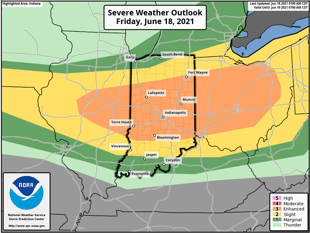
Severe Risks: Damaging wind, large hail, embedded tornado potential, flash flooding
Summary: A complex of thunderstorms to our north this morning will diminish. As a result, the cloud canopy engulfing much of the region this morning will give way to mostly sunny skies late morning and into the afternoon. Intense heat is expected this afternoon, courtesy of a southerly flow ahead of an approaching warm front and upper air disturbance. Highs will reach the lower to middle 90s this afternoon and heat indices will climb to between 100° and 105°. This heat, combined with a multitude of other ingredients: dew points into the 70s, convective available potential energy (CAPE) in excess of 4000 j/kg (suggestive of extreme instability), and steep low level lapse rates (rate of temperature change with height) all will play into what looks like a significant setup for a severe weather outbreak later this afternoon and tonight.
Initially, individual cells are likely to erupt (targeting mid to late afternoon) along an OFB (outflow boundary) across n-central Indiana. Damaging wind and large hail are the biggest concerns with these cells, but a tornado threat is also on the table in this highly unstable environment. Eventually the scattered, intense cells should congeal into more of a widespread storm complex by evening and impact most of central and southern parts of the state. Precipitable water values will be in excess of 2” and promote a flash flood risk, especially if thunderstorms back-build and train over the same communities. Should this be the case, localized rainfall amounts of 3”-4” will be a good bet. As we progress into the overnight hours, the storm complex and associated flood risk will shift downstate.
Confidence: HighN
Permanent link to this article: https://indywx.com/2021/06/18/client-brief-severe-weather-event-and-flash-flood-potential/
May 28
Updated 05.28.21 @ 7:31a
You must be logged in to view this content. Click Here to become a member of IndyWX.com for full access. Already a member of IndyWx.com All-Access? Log-in here.
Permanent link to this article: https://indywx.com/2021/05/28/video-detailed-breakdown-of-the-long-holiday-and-race-weekend-looking-ahead-to-next-week/
May 26
Updated 05.26.21 @ 7:57a
You must be logged in to view this content. Click Here to become a member of IndyWX.com for full access. Already a member of IndyWx.com All-Access? Log-in here.
Permanent link to this article: https://indywx.com/2021/05/26/video-stronger-storm-threat-friday-am-ahead-of-unseasonably-chilly-push-of-air-for-the-long-holiday-weekend/
May 03
Updated 05.03.21 @ 7:29a
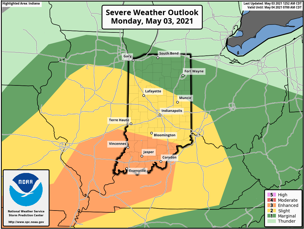
Light rain is currently falling across most of central Indiana. That will end by late morning to early afternoon (west to east) and we’ll then likely get several dry hours into the evening. By this time, all eyes will be focused to our west as a line of storms is expected to erupt across MO and IL by late afternoon. It’s this line of storms that will potentially impact Indiana towards late evening.

The Storm Prediction Center (SPC) has nudged southwestern Indiana into an “Enhanced Risk” of severe weather today. A good chunk of the remainder of the state is under a “Slight Risk.” Damaging winds are the greatest concern within the aforementioned potential line of storms later this evening.
Unsettled weather will remain in place Tuesday, including the opportunity for additional rain Tuesday evening/ night.

Most area rain gauges should pick up between 0.75″ and 1″ of rain by Wednesday morning, but there will be locally heavier totals for communities that find themselves under stronger storms.
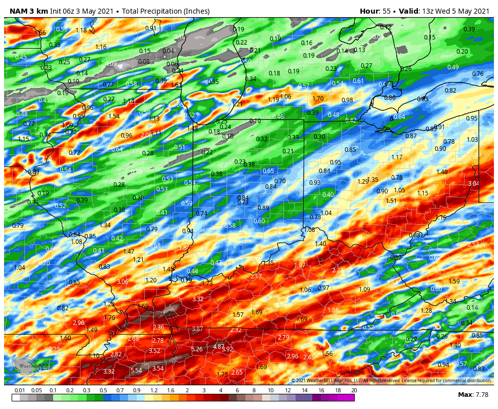
Dry weather will be hard to come by in the week ahead. We’ll get a brief break in the action Wednesday, but upper level energy will spark additional shower chances by Thursday. Unfortunately, Mother’s Day weekend looks quite unsettled, including additional opportunities for rain into early next week.

If that’s not enough, temperatures will also shift to a much cooler than normal feel for the 2nd half of the week (highs in the 50s and 60s and lows in the 30s and 40s). Don’t put those jackets away just yet…
We’ll be back later this afternoon with a fresh look at tonight’s storm threat.
Permanent link to this article: https://indywx.com/2021/05/03/timing-out-strong-storm-potential-blast-of-unseasonably-cool-air-on-deck/
Apr 30
Updated 04.30.21 @ 7:41a
You must be logged in to view this content. Click Here to become a member of IndyWX.com for full access. Already a member of IndyWx.com All-Access? Log-in here.
Permanent link to this article: https://indywx.com/2021/04/30/video-pleasant-open-to-the-weekend-dont-put-those-jackets-away/