Cold With Developing Snow For Colts v. Bengals

Colts v. Bengals Forecast Prepared For:
The Indiana Sports Report
01.04.14

Happy game day Colts fans and welcome to the start of the 2015 NFL Playoffs! (Hard to believe)! Today will feature quite a few weather changes when we compare this morning to tonight, but the main message we want to pass along is “get ready for winter!” While temperatures this morning are relatively mild, readings will fall rapidly this afternoon and we forecast left over moisture to transition to light snow and snow showers this afternoon into the evening. Additionally, winds will be strong and gusty. Tailgaters should prepare for cold conditions with rain showers mixing with and transitioning to snow by afternoon. Bundle up and GO COLTS!

Tailgate Weather

Kickoff Weather

Heading Home

Light rain mixing with light snow Snow showers and windy Snow showers and windy
Temp: 32-35 Temp: 32-35 Temp: 24-27
Wind:  SW 10-20 MPH Wind: W 10-20 MPH Wind: NW 15-25 MPH
Precip: 0.05” Precip: Trace Precip: 0.50”

ISRlogo2-280x121

Snow Showers Arrive Sunday; More Snow And Dangerous Cold Ahead…

Lots to discuss through the upcoming 7 days so please be sure to click the video and hear our latest thinking.  Have a great Saturday!

You must be logged in to view this content. Click Here to become a member of IndyWX.com for full access.  Already a member of IndyWx.com All-Access?  Log-in here.

Stretch Of Severe Winter Weather Next Week.

Just wanted to touch on a couple of bullet points for the upcoming week before a more extensive forecast update a bit later this afternoon.  A period of severe winter…

You must be logged in to view this content. Click Here to become a member of IndyWX.com for full access.  Already a member of IndyWx.com All-Access?  Log-in here.

Wintry Mix To Rain Saturday; Snow And Bitter Air Next Week…

Tonight’s video update covers the upcoming 7-day period.  A very brief shot of mild air will result in a change from early morning freezing rain Saturday to an all rain event before switching back to light snow Sunday as colder air moves in.  This is only the beginning of a very cold week ahead, complete with the chance of accumulating snow Monday night into Tuesday.

Forecast radar suggests a brief period of freezing rain can be expected during the wee morning hours Saturday.


Ensemble data shows temperatures more than 20 degrees below normal by mid week as a brutal shot of arctic air invades the region.

Detailed Christmas Eve Breakdown…

In what’s been an agonizing 6-7 days it’s only fitting that this will come down to the very end. Model performance has been poor, at best, concerning our Christmas Eve storm and given many forecasters a gray hair or two (yours truly included).

We’re going to lay out our best thinking below, but I want to be very clear when I say that we’re in a “now cast” mode for the rest of the day. It’ll be particularly important to have a means of gathering the latest weather information if you have travel plans later today.

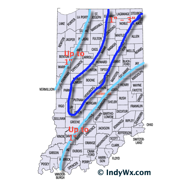
Overnight model data shifted the track of a developing surface low east. After looking over all of the available data, we now have converged on a surface low track that moves northeast from west Tennessee into northwest Ohio. The surface low will strengthen as it moves northeast, helping wrap cold air into the system and change rain to a wet snow across central Indiana this afternoon and evening.

The tricky part comes into play when we get into the details. Banding features and associated precipitation rates will be key in determining when local communities see a transition to wet snow and ultimately how much accumulates. This won’t be a “uniform” type accumulation event.  Dynamics with this system are impressive, despite only marginally cold air. If we get into a situation where heavier banding develops it won’t take long to cool the entire column of air and result in localized moderate to heavy snow.

On the flip side, surface temperatures are mild after a day yesterday into the middle 50s. Add in the fact stated above of only marginally cold air available and precipitation intensity will be key. If precipitation isn’t heavy enough, it’ll be tough for much snow to fall, yet alone accumulate.

Bottom Line:
As stated above, this is a now cast scenario through the rest of your Christmas Eve. Given all of the data we’ve looked at, this is how we see things playing out this evening:

  • Rain falls through the morning hours
  • Rain begins to first mix with and transition to snow across west-central Indiana between 12p-2p
  • Snow begins falling across most of central Indiana by 3p-4p
  • Snowfall could be locally heavy within localized banding that sets up. If this is the case, snowfall rates would be heavy enough to overcome relatively mild road surfaces and create travel issues.
  • Snow diminishes to flurries by 8p
  • Winds will gust in excess of 30 MPH this afternoon and evening
ChristmasEveSnowfall