Nice Finish To The Weekend; Mid Week Storm Brewing…
Screen Shot 2016-02-21 at 10.39.59 AMHighlights:

  • Beautiful finish to the weekend
  • Mid week storm brewing with many questions
  • Snow potential for some
  • Colder pattern developing

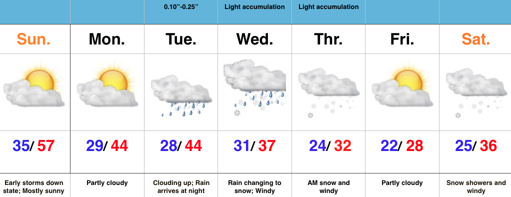
Nice Finish To The Weekend; Mid Week Storm Brewing…A disturbance responsible for overnight/ early morning thunderstorms and heavy rain across southern IN is tracking east.  Drier air is working in now and we’ve dialed up a beauty of a close to the weekend across central IN.

The work week will get started on a quiet note, but trouble is brewing for mid week as a big storm system lifts out of the southern Plains and into the lower Ohio Valley.  We forecast a lowering and thickening cloud deck Tuesday followed by rain developing.  As colder air gets pulled into the system, rain will begin to transition to a heavy, wet snow across portions of the area.  Exactly who sees the transition and when remain in question and will have to be fine tuned as time goes along.  That said, the potential is there for a heavy, wet snow “thump” across a portion of our area.  Stay tuned.

This storm will set things into a much colder and rather active time to close the work week and head into next weekend.
Thursday Evening Rambles…

1.) 10-day Client discussions (Pro and Premium) and our March Outlook (Premium) has been sent to your inbox. 2.)  A windy warm-up is still on track as we wrap up…

You must be logged in to view this content. Click Here to become a member of IndyWX.com for full access.  Already a member of IndyWx.com All-Access?  Log-in here.

Messy Monday Morning Commute; Watching Tuesday…

Screen Shot 2016-02-14 at 9.45.26 PMHighlights:

  • Freezing drizzle to start the day
  • Watching another storm system Tuesday
  • Mild and windy close to the week

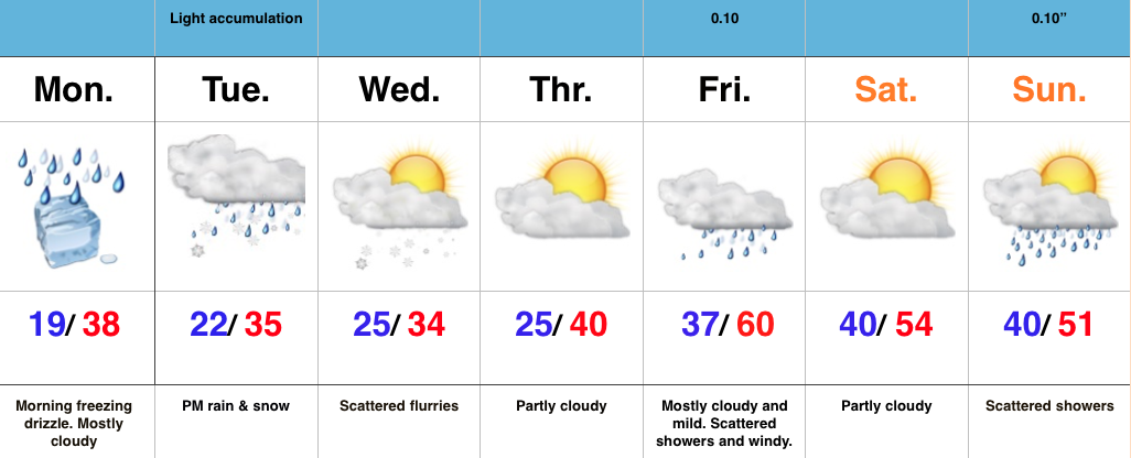
Messy Monday Morning Commute; Watching Tuesday…After the snowy Valentine’s Day across the region, we’re concerned freezing drizzle will develop and add to what already will be a slick commute in spots overnight and Monday morning. Allow extra drive time and take it slow.

Attention will quickly shift to Tuesday as a vigorous piece of upper level energy dives southeast. We have to fine tune the track later Monday, but this has the potential to spread a swath of accumulating snow over portions of the state Tuesday afternoon and evening.  Stay tuned.

We turn windy, but much milder to wrap up the work week. Friday and most of the weekend will feature a taste of spring as a strong SW flow takes hold and helps pump well above normal temperatures into the area.  Don’t get used to the mild air, as cold will return to wrap up Feb and head into March.

Interested in our consulting services?  E-mail bill@indywx.com for more information.