Damp At Times Into The Weekend; Christmas Pattern Change?
You must be logged in to view this content. Click Here to become a member of IndyWX.com for full access. Already a member of IndyWx.com All-Access? Log-in here.
You must be logged in to view this content. Click Here to become a member of IndyWX.com for full access. Already a member of IndyWx.com All-Access? Log-in here.
Highlights:
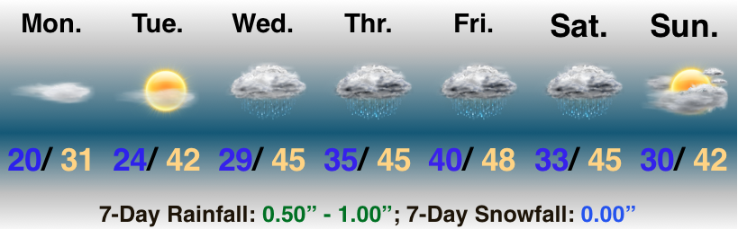
Slow It Down…Freezing fog is creating slick travel in and around the city, itself, and points north. Please allow extra time to reach your destination this morning and take it slow. As we move into the afternoon, the low clouds and fog should slowly lift, but it’s likely not until we get to mid to late afternoon. With the longer period of fog and clouds, we’ve dropped forecast highs a few degrees today.
We should still get in on a sunny Tuesday before our first of a series of storm system begin to impact the area Wednesday. Weak low pressure will result in increasing clouds and a narrow band of showers Wednesday afternoon. Rain may mix with snow across north-central parts of the state.
As we look ahead, a slow moving (bigger) storm system spells periods of wet weather as we close the week and head into the weekend. While it won’t rain the entire time, periods of moderate to heavy rain are possible during the period, along with gusty winds, and an overall “raw” feel. Early thinking here is that we salvage the 2nd half of the weekend with at least a touch of sun.
 Highlights:
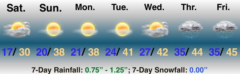
Brrrrrrr…It’s another frigid early December morning across central Indiana, but there really isn’t any “exciting” weather to discuss through the early part of next week. High pressure will supply quiet conditions through the daytime Wednesday. We’ll notice some mid and high level cloudiness today from a winter storm that will drop historic snow amounts across the southern Appalachians tonight into Monday. Otherwise, plentiful sunshine can be expected with slowly moderating temperatures into the new work week.
Clouds will lower and thicken Wednesday afternoon and light rain will likely arrive after dark. Our next storm system will deliver rain and gusty winds in here late week. Though we haven’t “taken the bait” just yet, there’s the chance of some wind-whipped wrap-around snow Friday. We’ll give it another couple model runs before building that into the forecast…
You must be logged in to view this content. Click Here to become a member of IndyWX.com for full access. Already a member of IndyWx.com All-Access? Log-in here.
Showers and embedded thunder will rumble across the state this evening before colder air allows precipitation to end as snow showers Monday morning. The same storm system will deliver a…
You must be logged in to view this content. Click Here to become a member of IndyWX.com for full access. Already a member of IndyWx.com All-Access? Log-in here.