Category: Windy

Sunday Mix; Heavier Winter Gear Needed Next Week…

screen-shot-2016-12-03-at-9-48-58-amHighlights:

  • Sunday mix
  • Wet Tuesday
  • Midweek snow and turning bitter

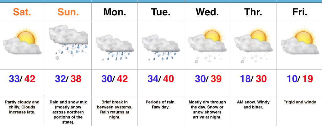
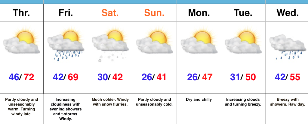
Winter Awaits…Today is chilly and dry. Thankfully, we’ll finally get to see the sun.  Enjoy it into the afternoon as clouds will quickly increase yet again later in the day as our next storm system approaches.

Speaking of that next system, moisture will spread into the chilly air mass Sunday morning.  Across central IN, this will fall as a wintry mix of light snow and chilly light rain.  Further north, this will be a mostly snow event, including a light accumulation possible (slushy amounts under 1″) across far northern portions of the state.  All-in-all, this won’t be a big deal.

We’ll have a brief break in between systems Monday before rain returns at night.  This is courtesy of another wave of low pressure lifting out of the northwest Gulf of Mexico, tracking northeast through the TN Valley and into southeastern Ohio.  Central Indiana snow lovers know that’s a classic track for snow around these parts this time of year.  We’ll keep an eye on it, but as of now, the air mass doesn’t look cold enough (yet).

A much colder pattern looms by the middle of next week.  Along with the arrival of the arctic air mass, we also favor a wave of low pressure delivering accumulating snow prospects Wednesday night into Thursday.  (That high Thursday will come at midnight with temperatures crashing through the day).  We’ll turn bitterly cold to close the week, including wind chills falling to around zero.

This is only the beginning of a very cold and wintry period.  There are plenty of “fun and games” awaiting as we rumble through the next couple weeks…

Upcoming 7-Day Precipitation Forecast:

  • Snowfall: 1″ – 3″
  • Rainfall: 0.75″ – 1.25″

Permanent link to this article: https://indywx.com/sunday-mix-heavier-winter-gear-needed-next-week/

Periods Of Rain; T-storm Chance Tonight…

screen-shot-2016-11-28-at-7-57-02-amHighlights:

  • Rain turns heavy tonight; Storm threat, too
  • Trending colder to open December
  • Next storm arrives over the weekend

A Wet Kick-Off To The Work Week…Moisture is streaming northeast over the Hoosier state this morning and this is really just the beginning of a wet and, eventually, stormy open to the work week.  We may see a brief “lull” in the rain around the lunchtime hour, but heavy rain will increase in coverage this evening and continue into tonight.  Additionally, we’ll introduce thunder into the mix this evening.  In fact, some of the higher resolution, short-term, forecast models hint at a skinny line of thunderstorms that may impact central IN tonight.  Strong wind gusts are of biggest concern with this line.  Here’s an idea of what the radar may look like around 8p.

8phrrrConsiderable cloudiness will remain Tuesday and Wednesday, but both days will be much drier than today.  A secondary wave of low pressure will move northeast along a pressing cold front Wednesday.  Best rain chances Wednesday will fall across eastern sections of the viewing area.

The second half of the week will trend colder.  A sprinkle or flurry is possible Thursday.  The next storm we’re tracking will arrive over the weekend.  Clouds increase Saturday and Sunday offers up the next good chance of rain.  Though details are sketchy at this point, the prospects of a storm system with more wintry significance may arrive just beyond the 7-day period.  Stay tuned.  December is looking quite active and wintry…

Upcoming 7-Day Precipitation Forecast:

  • Snowfall: Trace
  • Rainfall: 1.50″ – 2.00″

Permanent link to this article: https://indywx.com/periods-of-rain-t-storm-chance-tonight/

First Flakes Of The Season…

screen-shot-2016-11-19-at-8-14-33-amHighlights:

  • Colder pattern taking hold
  • First flakes of the season
  • Wet, windy system on the big travel day

Pull Out Those Heavier Coats…Last night’s cold front hit with authority and will likely be looked back on as the “game changer” between the warm, quiet fall we enjoyed and colder, more active times ahead.  Today is much colder with snow flurries and scattered snow showers. Gusty NW winds will feature wind chills in the 20s through the daytime before falling into the 10s tonight.

Calm, cold weather will continue into early next week before our next storm system blows into town Tuesday evening.  Clouds will increase through the day Tuesday and rain will arrive at night.  The big travel day before Thanksgiving looks blustery and wet with showers (especially during the first half of the day).  We’ll get the system out of here to allow for a dry, chilly Thanksgiving.

Looking ahead, another system of “interest” is on deck late next weekend or early the following week.  Timing and details are far from etched in stone with this being 7+ days out, but the potential is there for this to feature a wintry component…

Upcoming Precipitation Forecast:

  • Snowfall: Trace
  • Rainfall: 1.00″

Permanent link to this article: https://indywx.com/first-flakes-of-the-season/

VIDEO: Stormy By Evening; Much Colder This Weekend…

You must be logged in to view this content. Click Here to become a member of IndyWX.com for full access.  Already a member of IndyWx.com All-Access?  Log-in here.

Permanent link to this article: https://indywx.com/video-stormy-by-evening-much-colder-this-weekend/

Warm Today; Cold Changes Await…

screen-shot-2016-11-17-at-8-48-32-amHighlights:

  • Breezy and warm close to the work week
  • T-storms Friday evening
  • Cold weekend with Saturday flurries

Changeable Weather…If you don’t find a way to get outside today something is wrong.  Let the boss know IndyWx.com gave you permission to spend an extended lunch outdoors today. 🙂  Sunny skies and unseasonably warm temperatures will be with us through the day, along with an increasingly gusty afternoon wind.

Clouds increase Friday and showers develop Friday evening.  A couple of stronger thunderstorms are also possible as the front sweeps through the state.  While we’re not forecasting a widespread severe wind potential, one or two strong and gusty storms are possible.  The front will hit like a wall Friday night and feature an abrupt wind shift and plummeting temperatures.  That high Saturday in the lower 40s will be predawn as most of the day will be spent in the 30s with gusty winds and snow flurries.  Steadier snow squalls will be found across north and northeast IN.

Dry, chilly weather will be with us for the remainder of the weekend, continuing into the beginning of the Thanksgiving week ahead.  Our next storm system is slated for the big travel day Wednesday.  Expect showers and gusty winds followed by colder weather for Thanksgiving, itself.

Upcoming 7-Day Precipitation Forecast:

  • Snowfall: Trace
  • Rainfall: 0.50″ – 0.75″

Permanent link to this article: https://indywx.com/warm-today-cold-changes-await/