Category: Windy

Warm, But Unsettled Week…

Screen Shot 2017-01-16 at 7.26.31 AMHighlights:

  • Unseasonably warm week
  • Multiple rounds of rain and embedded thunderstorms
  • Eyeing winter’s return next week

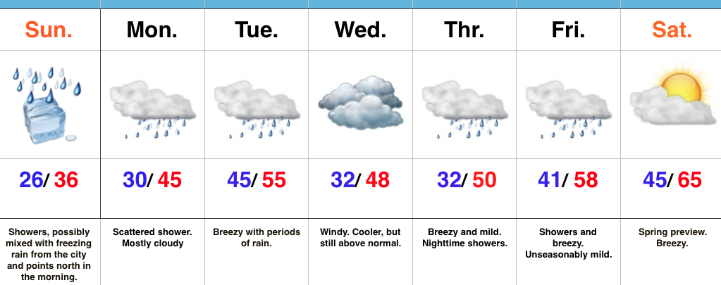
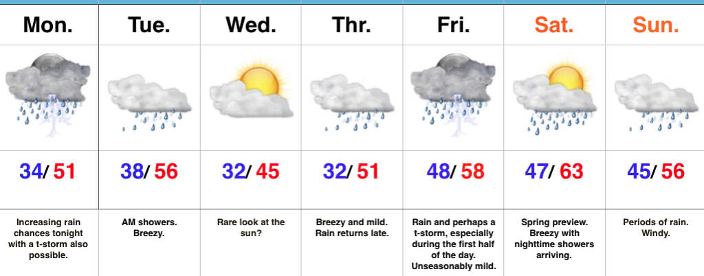
Have The Rain Gear Handy…While we’ll enjoy unseasonably mild temperatures, the wet and unsettled theme we’ve been dealing with as of late we’ll continue this week.

Most of the daytime today will feature more dry time than wet with just scattered showers expected before more widespread rain and embedded thunderstorms arrive by nightfall.  Wet and periodically stormy times continue tonight into the early morning hours Tuesday.  After a predawn high in the mid 50s, temperatures will slowly fall during the day Tuesday before remaining steady in the middle to upper 40s for the balance of the afternoon.

We may get a brief (rare) look at the sun Wednesday as we’ll be in between weather systems, but have no fear, as our next storm will be developing to our south and arrive with showers Thursday.  🙂  Rain and perhaps a thunderstorm continue Friday, especially through the first half of the day.

The majority of Saturday will feature dry and warm (early spring-like) conditions, but clouds will increase during the second half of the day and showers will push north into the state at night.  Windy, wet conditions continue Sunday.

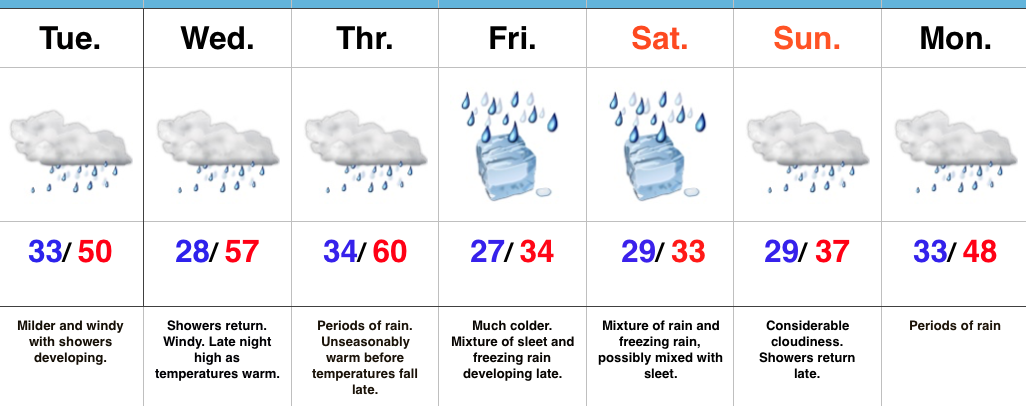
Longer-term, forecast models continue to paint a significantly colder, wintry pattern as we go through the last week of the month.

Upcoming 7-Day Precipitation Forecast:

  • Snowfall: 0.00″
  • Rainfall: 1.50″ – 2.00″

Permanent link to this article: https://indywx.com/warm-but-unsettled-week/

January Thaw For The New Week Ahead…

Screen Shot 2017-01-14 at 4.13.32 PMHighlights:

  • Damp, chilly Sunday
  • Milder week ahead
  • Spring-preview late next week

Improvements Coming…Most of tonight will feature dry conditions along with temperatures settling back below freezing (most of central IN will fall into the middle to upper 20s).  Another surge of light precipitation will arrive Sunday morning into the afternoon and this could begin as a period of freezing rain from the city and points north.  Similar to today, we don’t expect any major problems from the freezing rain and all of the region should warm above freezing during the afternoon.

While Monday could feature a quick-hitting shower at any given time, more widespread steady rain will push into central Indiana during the day Tuesday, along with breezy conditions.  Those breezy southwest winds will help give temperatures a boost into the middle 50s for afternoon highs.

We’ll shift that southwest wind around to the northwest Wednesday and this will help push cooler air into the state for mid week.  Despite the cooler feel, we’ll remain well above average with breezy conditions.  (Average highs in central Indiana are in the middle 30s this time of year).

The big news for the latter portion of the forecast period will be a true spring-like feel developing as we rumble into the weekend.  In fact, temperatures will surge well into the 60s next Saturday.  Modeling isn’t in total agreement on rain chances with a moist southwest flow in place.  We’ll take the “optimistic” route at this time and forecast a dry Saturday, understanding that we’ll have to maintain a close eye on things.

Quick heads up, longer term data continues to suggest we’ll flip into a much colder and stormy pattern as we wrap up January and head into February.  Winter is far from over…

Upcoming 7-Day Precipitation Forecast:

  • Snowfall: 0.00″
  • Rainfall: 0.50″ – 1.00″

Permanent link to this article: https://indywx.com/january-thaw-for-the-new-week-ahead/

Prolonged Stretch Of Gloomy Weather…

screen-shot-2017-01-10-at-7-25-16-amHighlights:

  • Active stretch of weather begins
  • Moderating trend into midweek
  • Ice concerns Friday-Saturday

Sunglasses NOT Required…We’re entering the beginning of an active stretch of weather, with an extended period of overcast skies and gloomy conditions.  Let’s dive in and take the challenges one-by-one:

Showers develop this afternoon as a cold front moves into the state.  Ahead of the front, strong southwest winds will gust upwards of 45 MPH+.  A “big hair warning” is in effect.  🙂

A brief shot of colder air will arrive late tonight into Wednesday, but just as soon as it arrives, it’ll leave and temperatures will approach 60 Wednesday night as showers return.

Thursday will be a wet day with periods of rain and slowly falling temperatures during the afternoon/ evening.

Friday is much colder as the arctic front will be to our south, but most of the day looks dry.  Moisture will lift north Friday afternoon and evening and with cold air in place, the precipitation should take the form of a mixture of freezing rain and sleet.  Periods of freezing rain likely continue Saturday.  It’s far too early to discuss amounts and we also want to reiterate the difference of 1-2 degrees will mean a world of difference between areas dealing with ice versus a cold rain.  The “battle zone” looks to take place across central IN.  If you have travel plans Friday night and Saturday, please keep abreast of later forecasts and updates.

Regardless of whether or not we’re dealing with icy conditions across central IN during the first half of the weekend, temperatures will warm during the second half of the weekend and change any frozen/ freezing precipitation over to plain ole cold rain Sunday into Monday.

Upcoming 7-Day Precipitation Forecast:

  • Snowfall: 0.00″
  • Rainfall: 1.50″ – 2.00″

Permanent link to this article: https://indywx.com/prolonged-stretch-of-gloomy-weather/

Busy Weather Week; Ice Storm Potential Friday Into The Weekend…

screen-shot-2017-01-09-at-7-26-23-amHighlights:

  • Late night light freezing rain develops
  • Milder and wet through mid week
  • Ice storm potential on the rise late week

Feeling Downright Balmy Out…Temperatures this morning (writing this at 7a) are running close to 20 degrees above where we were this exact time Sunday.  20 degrees has never felt so warm!  🙂  This moderating trend will continue into mid week, including temperatures that approach 60 Thursday.  That said, we have a mini “speed bump” to go over tonight and that’s the opportunity for light freezing rain late tonight into the wee morning hours Tuesday.  Temperatures should go above freezing just before the morning rush Tuesday, but plan to leave additional time as slick spots may remain.  Once we clear the “speed bump,” it’s off to the races in the temperature department through mid week: around 50 Tuesday afternoon and around 60 by Thursday (that’s a late night high Wednesday in the upper 50s).  Periods of showers will come with the milder air, centered on Tuesday and late Wednesday into Thursday.

Unfortunately, the milder times don’t last long and we still forecast “trouble” late in the week.  The set-up remains unchanged as a big, sprawling arctic high pushes into Wisconsin Friday.  This will help “shove” the arctic front through Indiana before stalling along the Ohio River Friday into Saturday.  As this is happening, ripples of energy will help ignite periods of precipitation Friday into the weekend.  With cold air locked in at the surface, we expect the potential of a rather prolonged period of freezing rain developing late Friday and continuing into the weekend.  We still have time for things to change, but from this distance, the predominant precipitation type, unfortunately, appears to be freezing rain.  Stay tuned as this could be a high impact event.

Upcoming 7-Day Precipitation Forecast:

  • Snowfall:  0.00″
  • Rainfall:  1.50″ – 2.25″

Permanent link to this article: https://indywx.com/busy-weather-week-ice-storm-potential-friday-into-the-weekend/

Changeable Weather; Late Week Ice Threat…

screen-shot-2017-01-08-at-10-01-49-amHighlights:

  • Another bitter day
  • Moderating temperatures ahead
  • Late week ice threat looms

Bitter Cold Gives Way To Moderating Temperatures…The first half of the forecast period is easy, but we caution big time headaches loom and details are far from etched in stone once to the second half of this forecast period.

First thing’s first and that’s today.  Look for a continuation of bitterly cold air, but slow moderation will be noted this afternoon: Not AS bitter and lighter winds.  We may even crack the 20 degree mark!  I know, break out the swim suits, right?!  This moderating trend is setting the tone for a more significant jump in the mercury later in the week.  Before a “taste of spring” arrives, we’ll have to deal with a brief opportunity for freezing drizzle Monday evening.  Temperatures will zoom to around 50 Tuesday and around 60 for mid week.  Showers will be with us off and on- focused on Tuesday and Thursday for most widespread coverage.

Then comes the “fun.”  A strong, sprawling arctic high will push south into the northern Plains Friday.  At the same time, “resistance” from the southeast ridge (that can be thanked for the spring-like feel here Wednesday and Thursday) will result in the arctic front only slowly being able to push south.  Ripples of energy, or waves of low pressure, will move along the arctic boundary and result in periods of widespread precipitation Friday into the weekend.  As the cold, dense arctic air oozes south, we have concern for icing- freezing rain and sleet Friday into Saturday.  Depending on how things evolve, this may continue into Sunday, as well.  If you have travel plans this weekend, please keep a close eye on the developments in the forecast from Friday on.  Stay tuned.

Upcoming 7-Day Precipitation Forecast:

Snowfall: 1.00″

Rainfall: 1.50″ – 2.00″

Permanent link to this article: https://indywx.com/changeable-weather-late-week-ice-threat/