Category: Windy

Friday Morning Rambles; Looking Ahead…

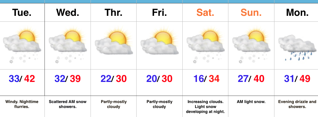
1.) A cold close to the work week can be expected with highs today only topping out in the upper 20s (average highs are in the upper 30s).

gefs_t2ma_1d_noram_52.) What at one time looked to be a significant weekend storm now may not even deliver any precipitation at all to the region.  A flurry is possible, but most should remain precipitation-free this weekend. Expect a gusty southwest wind developing SB Sunday.  Highs around freezing Saturday will zoom into the middle 40s Sunday.  Lows Saturday morning in the middle 10s will rise into the upper 20s to around 30 Sunday morning.

gfs_ptype_slp_conus2_9
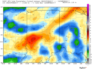
3.) A more significant storm system will cut for the Great Lakes early next week and this will deliver gusty showers and embedded thunderstorms.  A couple of stronger storms aren’t out of the question.  Locally heavy rains can be expected, including amounts of 1″-1.5″ (locally heavier totals).

gfs_ptype_slp_conus2_19

gfs_tprecip_indy_22
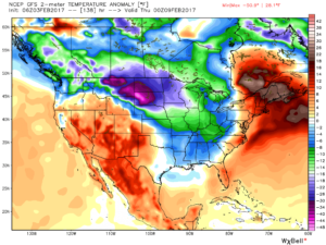
4.)  Cold air will rush back into the region behind the storm and snow showers and squalls are likely by Wednesday.

gfs_ptype_slp_conus2_22

gfs_t2m_a_f_conus2_24
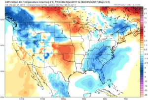
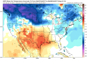
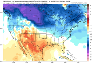
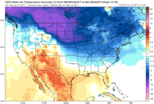
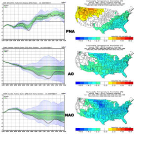
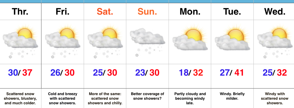
5.) Longer-term, a real fight is developing on the overall direction we’re heading as February evolves.  Analog methods and teleconnections (shown below) would yield bullish cold signals and give hope to winter enthusiasts.  However, modeling isn’t in agreement on the wintry ideas.  In fact, some modeling is very spring-like as mid-Feb nears.  Stay tuned as we try and iron out the details this weekend. Updates will come.

02.01.17Teleconnections

Permanent link to this article: https://indywx.com/friday-morning-rambles-looking-ahead/

Hold On To Your Hat; Accumulating Weekend Snow?

Screen Shot 2017-01-31 at 8.07.29 AMHighlights:

  • Windy Tuesday
  • Scattered flurries; snow showers tonight-Wednesday AM
  • Accumulating weekend snow?

Bumpy Ride…Wind will be the big weather item today as a clipper low passes to our north.  Gusty west breezes will reach 30 MPH at times.  Otherwise, it’ll be a mild day as highs reach the lower 40s.  Cooler air will arrive tonight and will promote the chance of a passing flurry or scattered snow shower into Wednesday morning.

We’ll close the week with cold and dry conditions, including highs below freezing both Thursday and Friday.

As we move into the upcoming weekend, a storm system will attack the lingering cold air and this will allow for a period of snow to develop Saturday night into Sunday morning.  We still have time to monitor this event, but as of now this appears to be a relatively weak, flatter wave and “light” is the key word to describe the snow intensity Saturday night into Sunday morning.

Models want to drive a more significant storm system to our northwest early next week.  What’s new this winter?  A windy warm-up would result, including heavier rains late Monday into Tuesday.

Upcoming 7-Day Precipitation Forecast:

  • Snowfall: 1″ – 2″
  • Rainfall:  0.25″ – 0.50″

Permanent link to this article: https://indywx.com/hold-on-to-your-hat-accumulating-weekend-snow/

Wintry Weekend; Accumulating Snow Sunday…

Screen Shot 2017-01-27 at 4.59.51 PMHighlights:

  • Wintry weekend
  • More widespread snow Sunday
  • Reinforcing cold next week

Scattered Snow Showers Turns To Steadier Snow Sunday…Upper level energy will continue to track across the region this weekend, setting off periods of snow showers and embedded heavier squalls (case in point this evening).  The strongest upper level energy will pass Sunday evening and the result should be a period of more widespread snow Sunday- especially in the afternoon and evening.  A light accumulation (1″-2″ potential) is possible.

The new work week will begin with early flurries Monday and then we’ll kick in a strong and gusty southwest wind Monday night, continuing into Tuesday.  We’ll turn milder briefly Tuesday, but strong winds will remain.  We’ll continue to monitor the Tuesday night-Wednesday morning period as some modeling wants to deliver a round of light snow with the reinforcing chill.  We’ll give it another round of model runs, but we may need to hit snow a little harder in the Tuesday night period.

Another disturbance will race through the region Thursday with snow showers and then we’ll eye the potential of a stronger system next weekend…

Upcoming 7-Day Precipitation Forecast:

  • Snowfall: 1″ – 3″
  • Rainfall:  0.00″ 

Permanent link to this article: https://indywx.com/wintry-weekend-accumulating-snow-sunday/

Snow Returns To The Forecast…

Screen Shot 2017-01-25 at 9.34.13 PMHighlights:

  • Prolonged period of scattered snow showers
  • Much colder and windy
  • Winter returns

Scattered Snow Showers; Steadier Snow Sunday?  Let’s cut right to the point:  The January “thaw” is over.  Yes, it was nice while it lasted, but we all knew it couldn’t continue (right?)!  😉

A much colder brand of air will be with us as we close the work week and head into the weekend.  Additionally, upper level energy will keep periods of snow showers in our forecast.  A more vigorous piece of upper level energy will push southeast to close the weekend and this should create more widespread snow showers.  We’ll “enjoy” a colder and blustery weekend.

As the dawn of a new work week arrives, the weather will slowly improve.  Colder than normal conditions will remain, but we’ll return to dry conditions Monday.

Our next system will pass Tuesday with gusty winds and colder air for mid week, complete with a return of snow showers.

Looking for potential of “more significant” snow?  That may loom just past the current forecast period…

Upcoming 7-Day Precipitation Forecast:

  • Snowfall:  1″ – 2″
  • Rainfall:  0.00″

Permanent link to this article: https://indywx.com/snow-returns-to-the-forecast/

Wednesday Morning Weather Brief…

Your complete weekly discussion can be found in the post below from last night, but here’s a recap of our current 7-day:

Screen Shot 2017-01-24 at 9.49.46 PM
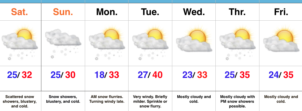
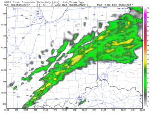
Showers will expand in overall coverage as we progress through the late morning hours, but shouldn’t amount to much (0.10″ for a few neighborhoods).  We return to a drier theme this afternoon.

10a forecast radar

10a forecast radar

11a forecast radar

11a forecast radar

A mild and windy afternoon is ahead, including gusts close to 40 MPH and highs in the lower-middle 50s.

Colder air will return tonight and remain in place through the second half of the work week, including the upcoming weekend.  Temperatures will grow cold enough Thursday morning for scattered snow showers.

Low-mid 30s Thursday morning

Low-mid 30s Thursday morning

Upper level energy will keep scattered snow showers going late week and on into the weekend.  Models can struggle on timing and specifics of the pieces of energy and we’ll keep an eye on things into the weekend.  Potential is present for a more “robust” clipper Sunday that could yield better coverage of steady snow showers.

gfs_namer_106_500_vort_ht_s
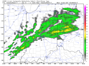
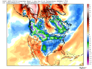
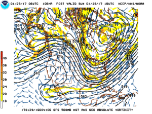
Longer term, the GFS ensemble continues to show the cold growing deeper and stronger for the region as we progress into early February.  Winter is far from over.

gfs-ens_T2maMean_us_5

gfs-ens_T2maMean_us_8gfs-ens_T2maMean_us_10gfs-ens_T2maMean_us_12

Permanent link to this article: https://indywx.com/wednesday-morning-weather-brief/