Category: Windy

Severe T-storms This Evening Give Way To Much Colder Air This Weekend…

Highlights:

  • Record warmth
  • Severe t-storm potential this evening
  • Scattered snow showers Saturday
  • Active pattern next week

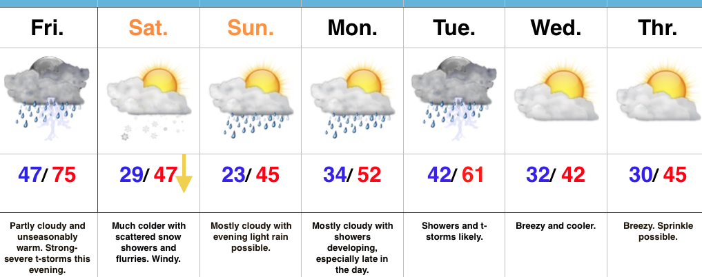
Focused On Severe Weather This Evening…Though the day is beginning on a quiet note, we’re concerned it might not end that way, as strong to severe thunderstorms impact central Indiana this afternoon and evening.  The sunshine this morning is actually something that adds further concern for the potential of explosive thunderstorm development later today.  More specifically, we’re bracketing the hours of 4p and 10p for the likelihood of storms impacting central parts of the state (west to east), and some of these may become severe.  All modes of severe weather are in play today, including large hail, damaging winds, and a tornado or two.  Please have a means of getting the latest warning information and ensure you know your family’s severe plan.  Otherwise, we forecast to shatter the record high today as we zoom all the way into the middle 70s with a gusty southerly wind.

Winter will return with authority tonight and set-up a much colder weekend.  That high in the upper 40s Saturday will actually come at midnight with falling temperatures (most of the daytime hours will feature low-mid 30s with ‘chills in the 20s), windy conditions, and scattered snow showers.

A weak weather system is looking less and less impressive for the second half of the weekend, but we’ll continue to keep a chance of light rain in our forecast by evening.

Better rain chances will begin to ramp up Monday evening and become widespread Tuesday, including the possibility of thunderstorms, as well.  The second half of next week will trend colder…

Upcoming 7-Day Precipitation Forecast:

  • Snowfall: Trace
  • Rainfall: 0.50″ – 1.00″

Permanent link to this article: https://indywx.com/severe-t-storms-this-evening-give-way-to-much-colder-air-this-weekend/

Active Pattern Ramping Up; Monitoring Multiple Storm Chances…

Highlights:

  • Spring-like air continues
  • Severe t-storm potential Friday PM
  • Much colder weekend
  • Another round of strong-severe storms next week?

Buckle Up For A Wild Ride…Morning fog (some very dense, especially north of the city) will burn off and give way to increasing sunshine today, along with unseasonably warm temperatures.  In fact, we’ll be near-record territory (Indy’s record high today is 70° and we forecast to tie that record this afternoon).  We’ll remain near record territory over the next couple of days, but our attention will, unfortunately, have to shift from the record warmth to strong-severe thunderstorm potential.

Most of Thursday will be dry, but a few scattered showers will likely dot the central IN landscape by the evening hours.  Similar to Thursday, most of the day Friday will also be dry.  It’s not until we head into Friday evening and night that we’re concerned for thunderstorms tracking through the state.  A few of these storms will likely reach severe levels.  Large hail and damaging winds are of greatest concern with the severe thunderstorms that develop.  The cold front will sweep the state Friday night and a midnight high Saturday morning in the upper 40s will crash (most of the daytime will feature temperatures in the 30s with wind chills in the 20s) and wind-whipped snow flurries can be expected.

A weak weather system is still expected late Sunday and could feature a light rain and snow mix (not a big deal).  What will be a bigger deal is a much stronger storm system rolling through the Mid West early next week.  Unfortunately, another round of strong to severe thunderstorms will be possible Tuesday…

Upcoming 7-Day Precipitation Forecast:

  • Snowfall: Trace
  • Rainfall: 1.00″ – 1.50″

Permanent link to this article: https://indywx.com/active-pattern-ramping-up-monitoring-multiple-storm-chances/

Incredible February Warmth Continues Until This Weekend…

Highlights:

  • Unseasonably warm conditions continue
  • Strong-severe t-storm potential Friday PM
  • Much colder this weekend

Spring-Like Weather Continues…A weak weather system will create the chance of showers into this afternoon, but many more dry hours can be expected than wet.  In fact, some neighborhoods won’t even see a drop of rain today.  The bigger news?  A continuation of unseasonably warm, April-like, temperatures.  In fact, we’ll turn even warmer for the second half of the work week and get back to dry time Wednesday and most of Thursday.

A strong cold front will sweep through the state Friday night.  Ahead of this front, shower and thunderstorm coverage will increase Friday afternoon into the evening hours.  Some of these storms may become strong to severe and include damaging straight line winds and hail.

We’ll then turn much colder Friday night and that will set the stage for a more seasonable weekend.  Snow flurries may fly in the blustery northwest flow Saturday.  A fast-moving weather maker will then spread a mixture of rain and wet snow across the state Sunday evening into early Monday.  Confidence is low on timing of this late weekend system and fine tuning will be required moving forward.

Upcoming 7-Day Precipitation Forecast:

  • Snowfall: Trace – Dusting
  • Rainfall: 0.25″ – 0.75″

Permanent link to this article: https://indywx.com/incredible-february-warmth-continues-until-this-weekend/

Spring-Like Now, But Winter Returns This Weekend…

Highlights:

  • Dense morning fog
  • Tuesday showers
  • Severe potential Friday
  • Much colder this weekend

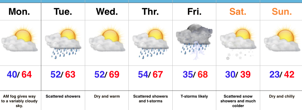
Two Seasons This Week…We’re starting the work week with dense fog across central Indiana.  This will eventually burn off to a variably cloudy sky by afternoon, along with continued unseasonably warm temperatures.

A weak weather system will press through the state Tuesday and this will help lead to a period of showers Tuesday morning into the early afternoon hours.  This won’t be a big event (most neighborhoods should accumulate between 0.10″-0.25″ of rain), but plan to pack the rain gear as you leave the house Tuesday morning.

A much stronger storm system will impact the region Thursday into Friday.  As strong low pressure passes by to our northwest it’ll help pull anomalously warm, moist air northward Friday.  Strong to severe thunderstorms may occur along the strong cold front that will pass late Friday.  While we still have time to “fine tune” details on timing, early thinking would place greatest emphasis on large hail and damaging wind potential.  Stay tuned.

Much colder air will hit with authority Friday night and set-up a wintry weekend.  The spring-like feel of this past weekend will be all but a distant memory and flurries may fly Saturday morning in the colder, blustery air.

Upcoming 7-Day Precipitation Forecast:

  • Snowfall:  Trace
  • Rainfall: 0.50″ – 1.00″

Permanent link to this article: https://indywx.com/spring-like-now-but-winter-returns-this-weekend/

Uneventful Weather; Warming Up Late Week…

Highlights:

  • Dry weather this week
  • Briefly cooler mid week
  • Weekend warm-up

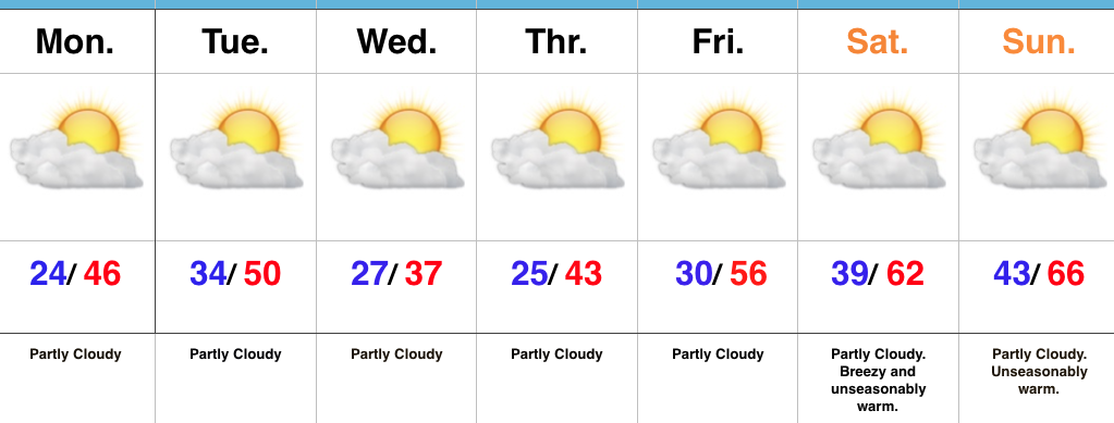
Sunglasses Required…We’re opening the work week with crystal clear blue skies and cold temperatures. Mostly sunny conditions will give way to increasing high level cloudiness this afternoon/ evening as a storm system passes by to our south.  That increase in cloudiness is about as “exciting” as it gets this week in the weather department.  Reinforcing chilly conditions will dive south into the region Tuesday night into Wednesday, but we’ll remain precipitation-free.

Like so many other cold blasts this winter, the chill won’t have staying power and we’ll get back to a moderating trend heading into the weekend.  Many places will likely come close to 70° by the second half of the weekend as dry conditions remain. Enjoy friends!

Upcoming 7-Day Precipitation Forecast:

  • Snowfall: 0.00″
  • Rainfall: 0.00″

Permanent link to this article: https://indywx.com/uneventful-weather-warming-up-late-week/