
You must be logged in to view this content. Click Here to become a member of IndyWX.com for full access. Already a member of IndyWx.com All-Access? Log-in here.
Category: Windy
Permanent link to this article: https://indywx.com/video-much-colder-busy-clipper-pattern/
Dec 04
Here Comes Winter…
 Highlights:
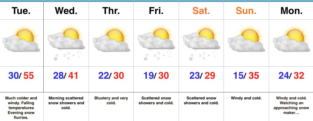
- Falling temperatures Tuesday
- Much colder
- Active northwest flow
Winter Engaged…Showers and embedded thunderstorms will rumble across the state during the overnight as a cold front draws closer. This is a “game changer” of a cold front, separating anomalous warmth over the past few days to a locked and loaded winter pattern. Temperatures will fall through the day Tuesday and just enough wrap around moisture will be present to support mention of evening flurries.
Morning scattered snow showers will continue early Wednesday before a reinforcing blast of arctic air blows into town at night. This will set up a frigid close to the work week and feature a fast paced northwest flow pattern into the upcoming weekend. We’ll have to remain very focused on upper level energy over the weekend. Models have been struggling (as expected given the pattern) on the specifics and we know this type regime can overachieve in the snow department. As things stand now, a period of snow showers with light accumulation still seems like a good bet Friday into Saturday.
Another (potentially more significant) snow event looms early next week…
Upcoming 7-Day Precipitation Forecast:
- Snowfall: 1″
- Rainfall: 0.25″ – 0.75″
Permanent link to this article: https://indywx.com/here-comes-winter/
Dec 04
VIDEO: Party’s Over After Today…
You must be logged in to view this content. Click Here to become a member of IndyWX.com for full access. Already a member of IndyWx.com All-Access? Log-in here.
Permanent link to this article: https://indywx.com/video-partys-over-after-today/
Dec 03
Winter Sets In…
 Highlights:
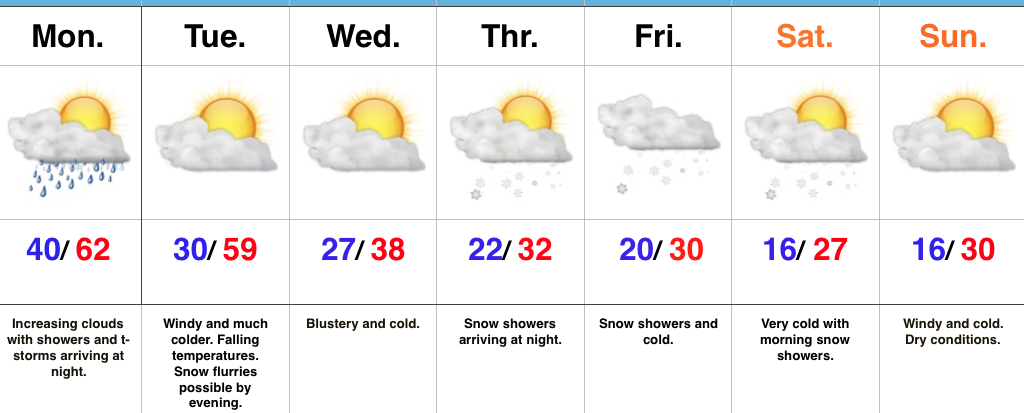
- Showers and t-storms Monday night
- Turning much colder
- Snowy close to the work week
Changes Loom…We couldn’t have asked for a more delightful weekend to open December. Plentiful sunshine helped warm afternoon highs into the 55-60 degree range both Saturday and Sunday across central Indiana. We sure hope you found a way to get out and enjoy it as major changes loom.
A cold front responsible for ushering in these changes will blow through the state Tuesday morning. Ahead of the cold front, look for a line of showers and thunderstorms Monday night. For the most part, rain should be southeast of our region before the morning rush Tuesday. Winds will shift to the northwest and help usher in a much colder air mass through the day. This will set the tone for what the rest of the week will hold (and for that matter, most of the rest of the month).
Cold, dry conditions will be with us for midweek before a vigorous upper level disturbance races southeast across the Ohio Valley to close the work week. Snow showers and unseasonably cold conditions are a given Thursday night through Saturday morning and we’ll have to continue to monitor things closely for the prospects of the season’s first accumulating snow Friday. These type events have been known to “overachieve.”
The cold pattern is just setting in and shows no signs of departing in the longer range. Additional wintry “mischief” looms next week…
Upcoming 7-Day Precipitation Forecast:
- Snowfall: 1″ – 2″
- Rainfall: 0.50″ – 0.75″
Permanent link to this article: https://indywx.com/winter-sets-in/
Nov 28
VIDEO: Generally Quiet Weather Continues (For Now)…
You must be logged in to view this content. Click Here to become a member of IndyWX.com for full access. Already a member of IndyWx.com All-Access? Log-in here.
Permanent link to this article: https://indywx.com/video-generally-quiet-weather-continues-for-now/