
You must be logged in to view this content. Click Here to become a member of IndyWX.com for full access. Already a member of IndyWx.com All-Access? Log-in here.
Category: Windy
Permanent link to this article: https://indywx.com/video-moderate-to-heavy-snow-moves-in-monday-morning/
Jan 13
Another “Plowable” Snow Gives Way To Sub-Zero Cold…
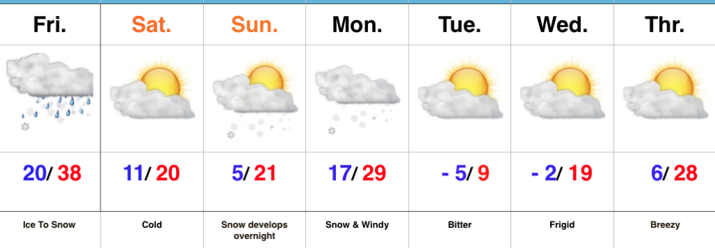
With the exception of light lake effect snow showers today (noticing a couple of light bands just west of the city as we write this Saturday morning around 10a), most of today and Sunday will be dry and cold. We’ll top out around 20° today and Sunday with low temperatures tonight dropping into the 0° to 5° range.
Our next snow maker will arrive late Sunday night into Monday morning in the form of a clipper system.
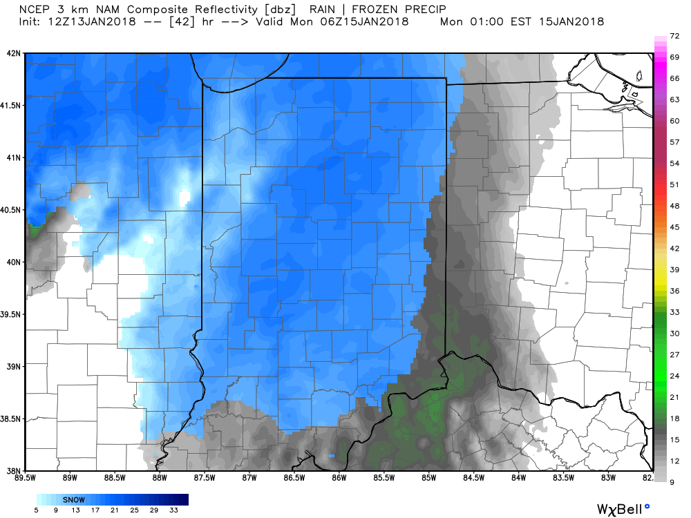
Forecast radar 1a Monday.
We expect light snow Monday morning to grow in overall coverage and intensity through the late morning and into the early afternoon hours.
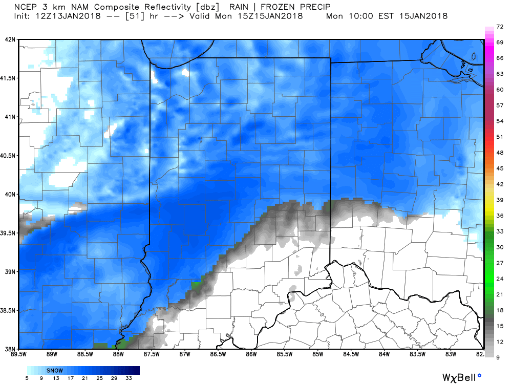
Forecast radar 10a Monday.
Accumulating snow will push off to the south Monday evening.

Forecast radar 7p Monday.
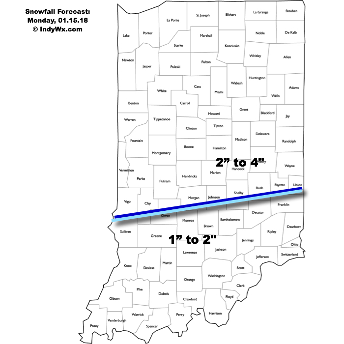
This will be a plowable event for central Indiana and we’ll also have to deal with blowing and drifting concerns Monday afternoon through Monday night as strong and gusty northwest winds arrive. Needless to say, to our snow removal and DPW crews out there, find a way to get some rest this afternoon and Sunday before another busy stretch to open the work week. We think additional snowfall of 2″ to 4″ is a good bet across the northern half of the state, with slightly lighter amounts of 1″ to 2″ across southern Indiana.
 Arctic high pressure will settle over a growing snowpack to help setup a frigid stretch through early and mid week. Multiple nights with below zero readings are expected beginning Tuesday morning where most will wake up to readings of 3° to 8° below zero (not counting the wind chill).

Permanent link to this article: https://indywx.com/another-plowable-snow-gives-way-to-sub-zero-cold/
Jan 12
Wintry Forecast; New “Plowable” Snow Event Arrives Monday…
 Highlights:
- Sleet changes to snow
- New snow and wind maker Monday
- Bitter air returns
Double Shot Of Impactful Winter Weather…A mixture of sleet and freezing rain will begin to transition to snow from west to east as we progress through the late morning into the early afternoon. We don’t have any significant changes to our snowfall forecast (remember this doesn’t include the freezing rain and sleet accumulations that have led to travel issues this morning already). Embedded snow bands will likely result in enhanced snowfall rates into the early afternoon across central Indiana.
 Precipitation will end for all except southeastern portions of the state by mid-to-late afternoon and then we’re left with the “clean up” from round one. Saturday and most of Sunday will feature dry and very cold conditions.
Our attention this weekend will then shift to a potent clipper system that has eyes on central Indiana late Sunday night into Monday. Snow will overspread the region during this timeframe and given the nature of this event, heavier, more intense snow bursts are also expected to accompany the fresh arctic air that will drill in here Monday evening. This will be an impactful event not only from the new falling snow, but from problems that wind and drifting will bring, along with a new batch of sub-zero temperatures. Our snowfall forecast Monday hasn’t changed since yesterday, including widespread additional amounts of 2″ to 4″.
 Dry, but bitterly cold conditions return for the mid and late week stretch.
Upcoming 7-Day Precipitation Forecast:
- Snowfall: 3″ to 6″
- Rainfall: 0.00″
*Please note the 7-day precipitation forecast outlined above is for Indianapolis proper.
Permanent link to this article: https://indywx.com/wintry-forecast-new-plowable-snow-event-arrives-monday/
Jan 11
Ice Transitions To A Double Shot Of Snow; Frigid Times Return…
 Highlights:
- Bye-bye thaw
- Ice to snow Friday
- Second snow maker Sunday night
Active Forecast Period…A breezy southerly flow will dominate our weather today ahead of an approaching cold front. Showers and unseasonably mild conditions can be expected today. (Despite the snow lover in me, I will admit that it’s been mighty nice being able to jog outside without worrying about slipping on ice or snow the past couple days).
Things begin to change in rather dramatic fashion tonight as the cold front presses through the state and allows much colder air to “ooze” back into central Indiana. At the same time, a wave of energy will track northeast along the cold front and help spread more widespread moisture into the colder air at the surface. We expect rain to begin mixing with and changing to an icy mixture of sleet and freezing rain after midnight across western and central portions of the state, and closer to 5a-6a across eastern Indiana. Eventually, as the entire column of air cools, icy precipitation will transition to snow. If the sleet to snow transition occurs faster, snowfall totals will be at the higher end of the first call numbers outlined below. Should sleet hold on for a longer period of time, snowfall amounts will be on the lower end of forecast totals. We think snow will end around noon west of the city, but steady snow will hang on much longer across eastern sections of the viewing area- well into the evening hours.
Here’s our first call snowfall forecast for Friday. While this doesn’t include freezing rain amounts, we think a glaze up to 0.10″ is a good bet – especially on elevated and exposed surfaces.
 Dry conditions will return Saturday along with a much colder feel. Quiet times won’t last long as another snow system will quickly begin to impact the state Sunday evening into Monday. Widespread steady snow is expected to develop and will actually be a more uniform, bigger, event for most of the viewing area. We’ll add in wind and arctic air which will lead to blowing and drifting issues as the day progresses Monday into Tuesday. Here’s our first call for additional snow amounts Sunday evening-Monday.
 The forecast period will wrap up dry and bitterly cold. With a fresh snowpack down, it’s safe to say we’ll add at least another night to the sub-zero “club!”
Stay tuned, friends!
Upcoming 7-Day Precipitation Forecast:
- Snowfall: 3″ to 6″
- Rainfall: 0.25″ to 0.75″
*Please note the 7-day precipitation forecast outlined above is for Indianapolis proper.
Permanent link to this article: https://indywx.com/ice-transitions-to-a-double-shot-of-snow-frigid-times-return/
Jan 09
Brief Thaw; Severe Winter Event Looms For A Portion Of The Region…
 Highlights:
- Fog and drizzle
- Major winter storm looms
- Frigid air returns
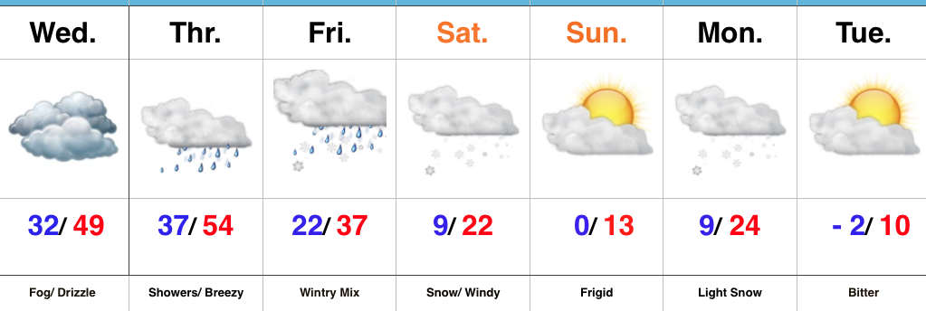
Brief Thaw; Major Winter Storm On Deck…The short-term will be dominated by low clouds and areas of fog, along with patchy drizzle. Areas of freezing fog and drizzle are possible early Wednesday morning before conditions “warm” in earnest through the afternoon and evening.
A cold front will approach from the northwest Thursday with showers and gusty southerly winds. This southerly air flow will deliver a briefly milder time of things during the day Thursday before the cold front settles south Thursday night. As this transpires, surface low pressure will organize along the southern end of the boundary before tracking northeast into the Tennessee and Ohio Valley Friday into Saturday.
We continue to favor a track up west of the spine of the Appalachians and note some of the more progressive data is beginning to correct west to align closer with the other guidance that’s been spitting out big snow numbers over the past few days. Before we discuss snow, an icy mixture of sleet and freezing rain will fall across the region late Thursday night into early Friday. We expect precipitation to transition to all snow Friday afternoon, continuing into Saturday. At times, heavy snow is likely.
While we aren’t ready to lay out an accumulation map just yet, the heaviest snow axis will likely include 8″ to 12″+ amounts somewhere through central portions of the state. We’ll aim to provide a first call snowfall map this time tomorrow. Furthermore, there will also be a wind component to this storm. What’ll initially be a wet, heavy snow will turn more “powdery” in nature as arctic air gets pulled into the storm. That powder will get blown and drifted about Friday night and Saturday and travel will be significantly impacted.
Frigid conditions will return over the weekend before another accumulating snow pushes into town Monday. Behind this snow maker, a brutal push of sub-zero air is likely next week.
Upcoming 7-Day Precipitation Forecast:
- Snowfall: 6″+
- Rainfall: 0.50″ to 0.75″
Permanent link to this article: https://indywx.com/brief-thaw-severe-winter-event-looms-for-a-portion-of-the-region/