Catching Up On A Tuesday Morning!

Good morning and happy Tuesday!  We’re looking forward to a beautiful, and warm, few days ahead before unsettled conditions return by late week.  The video covers those details below.

Monday’s highs displayed quite the spread across the state- ranging from near 90 down state to the upper 50s across far northeastern Indiana.  Here across central Indiana, many enjoyed upper 60s to near 70 on Monday.  (Click on the image to enlarge).

t0

Despite the surge of warmth coming mid week, and likely again early next week, the overall theme is one that’s cooler than normal for mid May.  Note the strong trough developing over the Great Lakes and Ohio Valley.
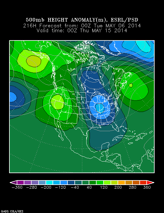
z500_anom_f216_ussm


Video discussing today’s forecast and looking ahead to the weekend and beyond:

Shaking Those Pesky Clouds And Chill!

Sat.

Sun.

Mon.

Tue.

Wed.

Thr.

Fri.

 Status-weather-clouds-icon

 Status-weather-showers-day-icon

 Status-weather-showers-day-icon

 Status-weather-clouds-icon

 Status-weather-clouds-icon

 Status-weather-clouds-icon

 Status-weather-showers-day-icon

45/ 65

48/ 65

45/ 67

50/ 71

55/ 81

61/ 83

63/ 73 

– – –

Light

Light

– – –

– – –

– – –

Light

The broken band of showers that moved through central Indiana during the predawn hours is now long gone and we’re now into sunshine!  We forecast a gusty wind through the day, but a pleasant day as highs reach the middle 60s.  A couple of showers are possible Sunday, but there will be many more dry hours than wet.  We’ll really begin to turn the thermometer up as we head into the middle part of the week before our next storm system approaches next weekend.

Video discussing today’s custom built IndyWx.com Forecast issued at 8:56am: