Saturday Morning Rambles: Eyes On Severe Threat To Open The Week And Winter’s Return…

Updated 02.25.23 @ 8:28a

  1. The remainder of our weekend should be quiet on the weather front. Take the opportunity to enjoy a calmer couple of days as an active week awaits.
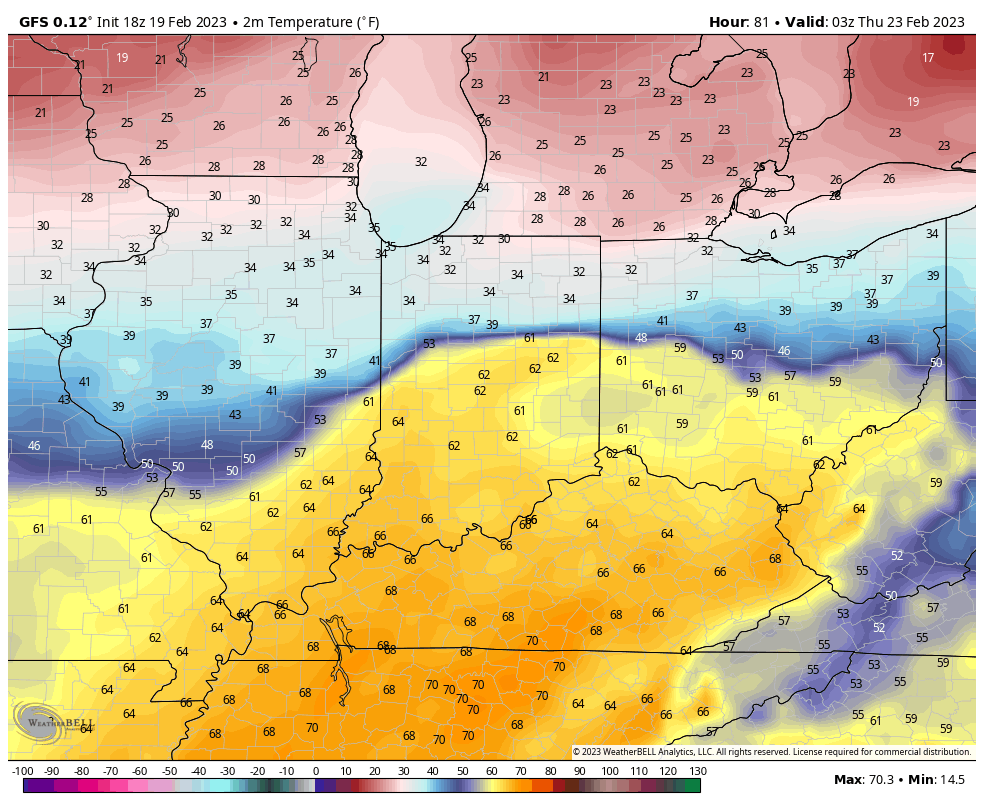
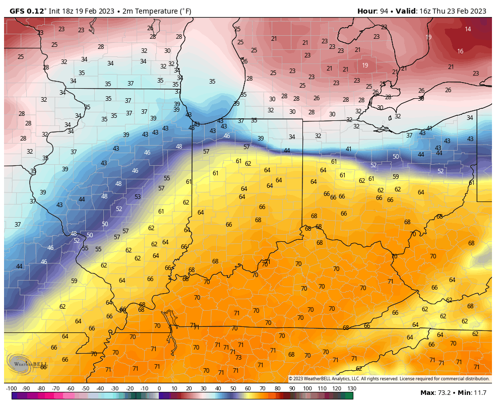
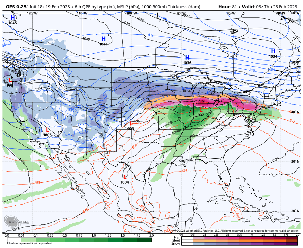
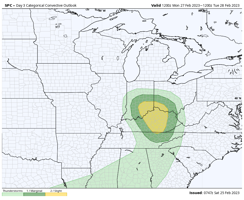
  2. A warm front will lift north through the region Sunday night with showers and embedded thunder. Temperatures will jump back into the lower and middle 60s across the southern portion of the state Monday morning. As a cold front swings into the relatively warmer and moist airmass, a line of stronger storms will be a good bet across the southern half of Indiana late Monday morning into early afternoon. A few of these may produce damaging winds and large hail, and there’s also potential for a quick spin up tornado. Strong and gusty winds (40-50 MPH) can also be expected across the entire region outside of storms.

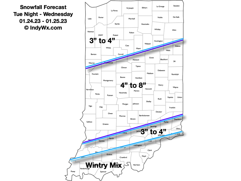
3. Attention will then shift to mid week as multiple pieces of energy try and bundle together to generate another size-able storm. Confidence on any one particular solution is low at this distance, but with colder air pressing east, this system will likely have a more widespread wintry component on the north and west flank. No reason to speculate further from this distance, but know we’ll continue closely monitoring trends.

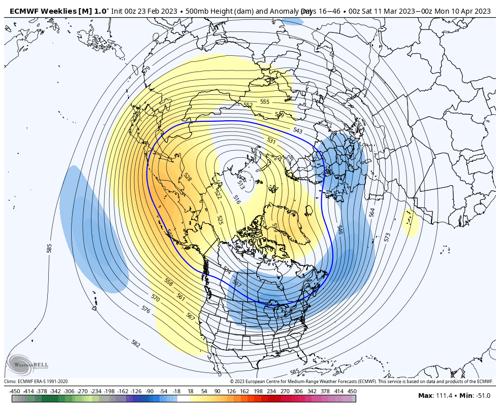
4. Finally, it continues to look like any and all who believed winter was over will be sorely mistaken. Confidence continues to grow in a cold to much colder than normal 2nd half of March, which likely continues to push into at least early April. Note the updated European Weeklies for the time period March 10 to April 10. That’s a classic look for significant late season cold. We’re also likely far from finished with wintry precipitation…

Few Miles Makes All The Difference This Week…

Updated 02.19.23 @ 5:54p

Spring will most certainly be in the air this week, at least for some. At the same time, there will be all sorts of whaling and gnashing of teeth for other areas that will be close to basking in the warmth, but yet so far at the same time. Note the significant temperature gradient that will set up shop across the region in the Tuesday through Thursday time frame.

A well organized area of low pressure will ride east along the stalled boundary separating the chill and near record breaking warmth. This feature will be responsible for widespread rain, locally, and an icy mixture of precipitation across the southern Great Lakes region. Steadiest rain will likely fall Wednesday evening and night before drier, colder air works in here to close the work week.

Despite a widespread 0.50” to 1” of rain during the aforementioned time period, at least the southern 2/3 of the state will enjoy 60°+ (in some cases 70°) weather midweek. Yes, spring fever will be running rampant.

We’ll likely do this all over again late in the weekend or early next week…

MJO And Other Drivers Aligning For Cold Close To Meteorological Winter; Open To Spring?

Updated 02.09.23 @ 8:53p

After a bitter Christmas period, the “snap back” came on with authority. The mild start to the year has carried into February. A look at the past (30) days:

Despite multiple attempts, the cold “jabs” haven’t had any staying power. In the short term (upcoming 10-14 days), an overall milder than normal regime will carry the day.

With that said, longer range teleconnections are providing clues that the pattern may, indeed, begin to resemble a more sustained colder than normal temperature regime by late February, continuing through the bulk of March:

Negative NAO:

Negative WPO:

Negative AO:

Negative EPO:

Then, perhaps most significant, the MJO is showing signs of cycling in Phase 8 to close February and open March.

Both periods feature a cold, to much colder than normal, pattern in Phase 8:

MJO Phase 8: Feb

MJO Phase 8: March

Perhaps the latest European Weeklies for late Feb through late March are onto the correct idea…

Monday Evening Notes On Upcoming Snowstorm; Additional “Wintry Mischief” On Deck…

Updated 01.23.23 @ 6:01p

While not “overly cold” (at least yet), we’re heading into a special pattern for snow/ winter weather lovers. After the leading wave of accumulating snow over the weekend, a much more “meaningful” storm eyes the region late tomorrow night and Wednesday.

In short, we don’t have any changes to our thinking since Saturday on this storm. Snow will lift in here from the south during the overnight and become heavy throughout the morning hours. Snowfall rates will likely approach, if not exceed, 1″ per hour during this time period and will lead to a horrendous morning rush all throughout the region. If you don’t absolutely have to travel, we recommend staying put. Embedded intense snow bands will likely pivot into the city throughout the morning, elevating those snowfall rates and reducing visibility.

Heaviest snow looks to fall in the 2a to 11a timeframe in the city, itself. This will be a wet, heavy (paste-like) snow.

We still don’t see a reason to alter our ongoing snowfall forecast published first to Clients Saturday. This is only for the Tuesday night-Wednesday period and doesn’t account for additional light snow accumulation that will take place Thursday into Friday. Needless to say, there will likely be some across central Indiana that close in on double-digit storm totals by the time all is said and done.

And just as soon as we catch our breath from this storm, attention will turn to the following winter weather makers:

  1. A clipper system that will scoot through the Great Lakes region Friday. This will likely lead to a period of more concentrated, albeit light, snow Friday PM. Additional light snow accumulation is possible across central and northern IN during this time period.

2. Another southern stream system approaches Saturday evening. While milder air will be present (at least aloft), it’s also very possible the modeling will be forced to correct colder after realizing what kind of deep snowpack will likely be deposited across the region midweek. Long story short, we feel this storm system will also be capable of producing a wintry mix of snow and/ or sleet and freezing rain Saturday night into Sunday. Additional details will have to be sorted out in more specific fashion after midweek.

Thereafter, with the negative PNA and negative EPO in place, we’re likely to deal with additional wintry “fun and games” into the middle and latter part of next week, but with this being more than 7 days out, there’s no reason getting too excited from this point with specifics.

Needless to say, we’re in about as good of a position as one could ask for accumulating winter weather events in the medium range period. We’ll just have to take one storm at a time.

Make it a great evening!