 Highlights:
- Active stretch of weather begins
- Moderating trend into midweek
- Ice concerns Friday-Saturday
Sunglasses NOT Required…We’re entering the beginning of an active stretch of weather, with an extended period of overcast skies and gloomy conditions. Let’s dive in and take the challenges one-by-one:
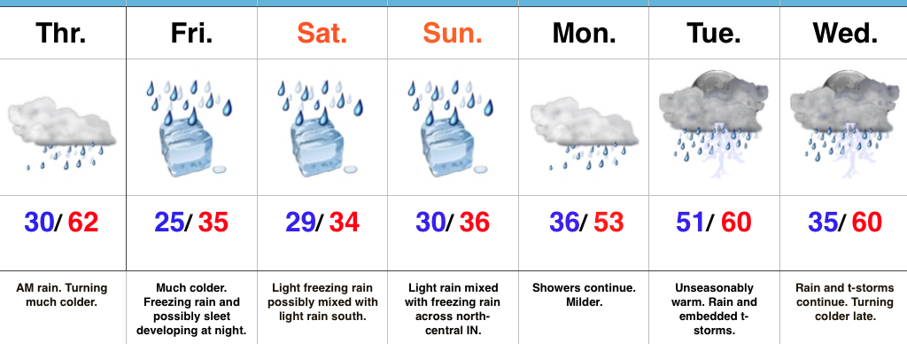
Showers develop this afternoon as a cold front moves into the state. Ahead of the front, strong southwest winds will gust upwards of 45 MPH+. A “big hair warning” is in effect. 🙂
A brief shot of colder air will arrive late tonight into Wednesday, but just as soon as it arrives, it’ll leave and temperatures will approach 60 Wednesday night as showers return.
Thursday will be a wet day with periods of rain and slowly falling temperatures during the afternoon/ evening.
Friday is much colder as the arctic front will be to our south, but most of the day looks dry. Moisture will lift north Friday afternoon and evening and with cold air in place, the precipitation should take the form of a mixture of freezing rain and sleet. Periods of freezing rain likely continue Saturday. It’s far too early to discuss amounts and we also want to reiterate the difference of 1-2 degrees will mean a world of difference between areas dealing with ice versus a cold rain. The “battle zone” looks to take place across central IN. If you have travel plans Friday night and Saturday, please keep abreast of later forecasts and updates.
Regardless of whether or not we’re dealing with icy conditions across central IN during the first half of the weekend, temperatures will warm during the second half of the weekend and change any frozen/ freezing precipitation over to plain ole cold rain Sunday into Monday.
Upcoming 7-Day Precipitation Forecast:
- Snowfall: 0.00″
- Rainfall: 1.50″ – 2.00″