Category: Unseasonably Warm
 Highlights:
- Wet open to the work week
- Shot of colder air
- Extended dry, sunny stretch coming
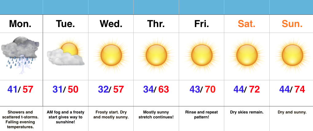
Good Supply Of Vitamin D Coming…While the work week is opening cloudy, wet, and gloomy, it certainly won’t end that way. Rain will end from west to east this afternoon. Before we get into the much deserved pattern change later this week, we’ll deal with one more shot of chilly air arriving tonight and Tuesday with a brisk NW wind. Sub-freezing temperatures are a good bet for most Tuesday and Wednesday mornings.
Once to Thursday, we’re “off to the races” as far as temperatures go- adding a couple degrees on afternoon highs each afternoon. Wall-to-wall sunshine will dominate the forecast as we wrap up the work week and head into the weekend. Enjoy, friends!
Permanent link to this article: https://indywx.com/this-is-more-like-it/
You must be logged in to view this content. Click Here to become a member of IndyWX.com for full access. Already a member of IndyWx.com All-Access? Log-in here.
Permanent link to this article: https://indywx.com/thursday-morning-video-update-2/
We open the forecast period dry and pleasant, but we turn stormy late Easter Sunday and MUCH colder air still looks to arrive as we welcome April. Details can be…
You must be logged in to view this content. Click Here to become a member of IndyWX.com for full access. Already a member of IndyWx.com All-Access? Log-in here.
Permanent link to this article: https://indywx.com/saturday-morning-video-update-4/
 Highlights:
- Showers and t-storms
- Chilly Good Friday
- Tricky Easter Forecast
Showers And Embedded Thunder Today…Showers and thunderstorms will be with us for the majority of the late morning and afternoon hours before a cold front sweeps through the state tonight and sets up a dry, but much colder time of things for Good Friday. Locally heavy downpours are a good bet today, including some 1″+ totals across central parts of the state.
The first half of the Easter weekend is looking very nice. Certainly of the two days, we’d recommend getting that Easter Egg Hunt in on Saturday as clouds will increase Easter Sunday and give way to late day rain. Modeling isn’t in agreement on the timing of rain Easter, but we’re siding more with the GFS approach for now (earlier arrival when compared to the European). Stay tuned as we fine tune ;-).
Our “topsy turvy” weather pattern will continue into next week, but we still eye a significant cold front and associated MUCH colder air mass during the first (10) days of April…
Permanent link to this article: https://indywx.com/wet-day-on-tap/
-
Filed under 7-Day Outlook, Forecast Discussion, Forecast Models, PSD, Rain, Spring, T-storms, Unseasonably Cool Weather, Unseasonably Warm, Weather Rambles
-
March 20, 2016
1.) Indianapolis is running much warmer (+9.1°) and slightly drier than normal (-0.15″) month-to-date. 2.) Snow is flying to our southwest, and accumulating for some in and around St.…
You must be logged in to view this content. Click Here to become a member of IndyWX.com for full access. Already a member of IndyWx.com All-Access? Log-in here.
Permanent link to this article: https://indywx.com/sunday-weather-rambles/
